
Central and Southern Illinois Face Highest Risk of Strong Long-Tracked Tornadoes Monday as Computer Models Shift Threat South and Timing Runs 3 PM Through Midnight
SPRINGFIELD, Illinois — The tornado threat for Monday, April 27 is coming into sharper focus as late morning model data trends south, concentrating the highest risk for strong, long-tracked tornadoes across central and southern Illinois. The threat window runs from 3 PM through midnight across all of Illinois, and two independent forecast tools are now converging on the same geographic bullseye — a signal that carries meaningful weight heading into the afternoon hours.
Where the Models Are Pointing — Central and Southern Illinois
The 11 AM model trends are shifting the highest tornado threat southward from earlier forecasts. The concentration of risk is now centered on central and southern Illinois, where the combination of discrete supercell potential in the early afternoon and squall line embedded tornadoes through the evening creates a prolonged threat window. Northern Illinois is not excluded — tornadoes remain possible there as well — but the greatest threat is now clearly embedded in the storm corridor tracking through the central and southern portions of the state.
The timing breakdown for Illinois:
- 3 PM onward — initial storm development possible across southern Illinois as the warm sector destabilizes ahead of the approaching cold front
- Afternoon hours — discrete supercell phase, the highest-risk window for strong, long-tracked tornadoes before storms grow upscale
- Evening through midnight — squall line phase with embedded tornado threat, damaging winds and heavy rainfall across the full length of the state
What StormNet Tornado Probabilities Show
The StormNet-v4 Tornado Probability forecast valid from April 27 18Z through April 28 06Z — covering Monday afternoon through Monday overnight — places a concentrated high tornado threat zone directly over central Illinois and into northwestern Indiana and southwestern Michigan. The probability gradient on the map is clear and significant:
- Yellow and orange shading (high probability — 0.6 to 0.7+) centered over central Illinois, covering Springfield, Decatur and the surrounding corridor
- Green shading (medium probability — 0.4 to 0.5) expanding through northern Illinois, southern Illinois and into Indiana and Kentucky
- Blue shading (low probability — 0.2 to 0.3) covering a broad outer zone from Iowa and Missouri through Ohio and Tennessee
- Gray shading (very low — 0.1) reaching across the full outer risk area from Nebraska to the Appalachians
The StormNet bullseye is centered directly over the same corridor that morning model trends are now highlighting — central Illinois — with the highest individual tornado probability values in the entire map concentrated over that region.
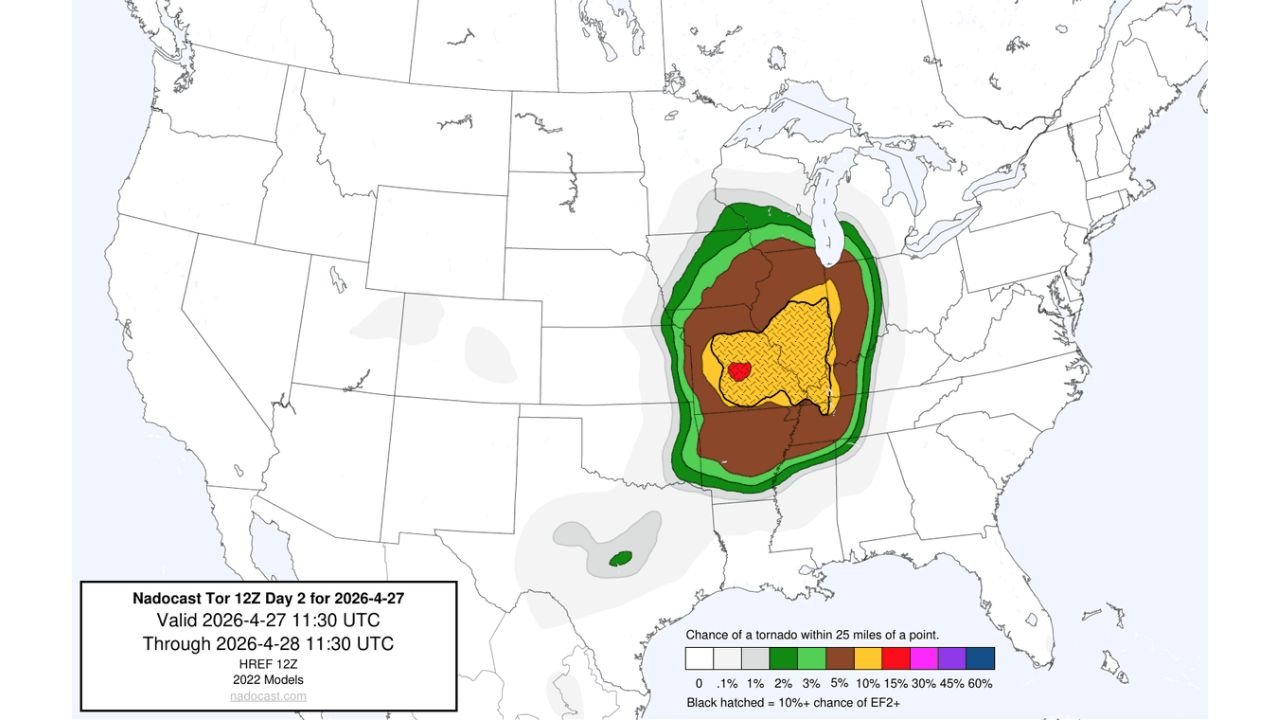
What the Nadocast Tor Forecast Confirms
The Nadocast Tor 12Z Day 2 forecast valid April 27 through April 28 at 11:30 UTC provides the second independent confirmation. This model calculates the chance of a tornado within 25 miles of any given point and produces its own geographic risk gradient:
- Red zone (45%+ chance of a tornado within 25 miles) — a tight bullseye centered over central Illinois, the highest value on the entire map
- Yellow zone with black hatching (30%+ with 10%+ EF2 or stronger tornado chance) — covering a broad area across central and southern Illinois, northwestern Indiana and western Kentucky. The black hatched pattern is the significant tornado signal — it identifies where EF2 or stronger tornadoes have at least a 10% probability of occurring within 25 miles
- Brown zone (15%) — extending through northern Illinois, Indiana, Missouri and Tennessee
- Green zone (5%) — the outer boundary reaching from Iowa through Michigan and into the Mid-South
- A secondary small risk area appears across the Gulf Coast, consistent with the southern storm development signal forecasters flagged for Oklahoma, Arkansas and Mississippi by early evening
The convergence of StormNet’s high probability bullseye and Nadocast’s red zone with significant hatching over the same central Illinois corridor is a meaningful signal. When independent forecast tools built on different methodologies agree on the same location, the confidence in that geographic focus increases substantially.
Cities Inside the Highest Risk Corridor
Highest tornado threat zone — central and southern Illinois:
- Springfield, Illinois
- Decatur, Illinois
- Champaign, Illinois
- Bloomington, Illinois
- Peoria, Illinois
- Carbondale, Illinois
- Mount Vernon, Illinois
Elevated threat — northern Illinois and adjacent states:
- Chicago, Illinois
- Rockford, Illinois
- Evansville, Indiana
- Paducah, Kentucky
- St. Louis, Missouri
What Strong Long-Tracked Tornadoes Mean for Central Illinois
A long-tracked tornado is one that remains on the ground continuously for an extended distance — sometimes crossing multiple counties without lifting. Central Illinois geography offers no natural terrain barriers to slow or redirect a tornado once it forms. Flat agricultural land from Springfield through Decatur and Champaign means a long-tracked tornado in this corridor can travel dozens of miles with minimal obstruction, affecting rural communities, small towns and larger cities in a single continuous path.
The EF2+ hatching from Nadocast over this same corridor means the models are not just forecasting tornado occurrence — they are forecasting significant, structurally damaging tornadoes capable of destroying well-built homes and producing life-threatening conditions across a wide swath of central Illinois.
What to Do Before 3 PM Monday
- Central and southern Illinois residents should finalize shelter plans before noon — the 3 PM storm initiation window does not allow for last-minute preparation
- Identify a basement or interior room on the lowest floor away from all windows as your designated tornado shelter now
- Mobile home and manufactured housing residents across the Springfield-Decatur-Champaign corridor must relocate to a permanent structure before the afternoon storm window opens — there is no safe shelter from a strong tornado inside a mobile home
- Keep multiple warning sources active simultaneously — a NOAA weather radio, phone alerts and a local broadcast source running together ensure no tornado warning goes unheard through the afternoon and evening hours
- The threat runs through midnight, meaning evening plans and overnight readiness both fall inside the risk window
WaldronNews.com will continue tracking Monday’s tornado threat across Illinois and provide updates on storm initiation, tornado warnings and track reports as the event unfolds through the afternoon and evening.