
Severe Storm Line With 70 mph Winds and Tornadoes Targets Indianapolis, Kokomo and Fort Wayne Monday Night Between 9 PM and Midnight
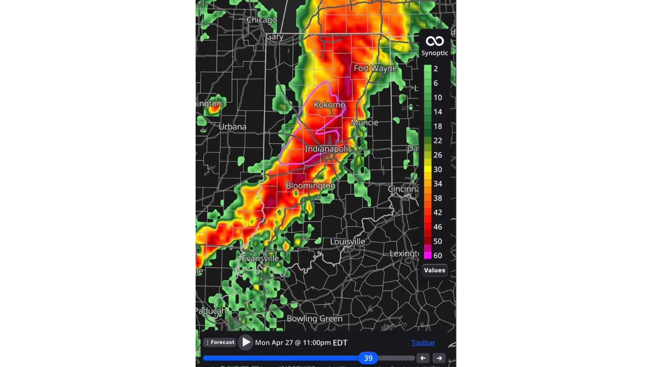
INDIANAPOLIS, Indiana — Morning forecast data is now painting a sharper and more alarming picture for Monday night across central and northern Indiana. A gnarly line of severe storms is expected to push through the region, with current timing placing the most intense activity between 9 PM and midnight Monday night. The storm line visible in the forecast radar valid Monday April 27 at 11 PM EDT shows a concentrated corridor of extreme reflectivity — deep red and pink shading — cutting directly through Indianapolis, Kokomo, Fort Wayne and Bloomington, with the heaviest intensity centered over the Indianapolis metro and the Kokomo-Muncie corridor.
The Four Threats in Order of Concern
Forecasters have ranked the hazards from this system explicitly, and the order matters for how residents should prepare:
- 1. Damaging winds — 70+ mph — the primary and most widespread threat with this storm line, capable of snapping large trees, collapsing structures, downing power lines across a broad swath and creating dangerous debris fields in every community the line crosses
- 2. Tornadoes — embedded within the line and possible ahead of it in any discrete supercell activity that precedes the main squall line arrival
- 3. Heavy rainfall and possible flooding — the storm line’s movement will determine rainfall totals, but a slow-moving or training segment could drop enough rain in a short period to produce flash flooding
- 4. Some hail — the lowest-ranked hazard but still possible, particularly with any discrete storm activity ahead of the main line
What the Radar Forecast Shows for 11 PM
The forecast radar valid Monday at 11 PM EDT shows the storm line in its most intense phase across Indiana. The pink outline on the radar image marks the highest-end reflectivity corridor, centered directly over Kokomo and Indianapolis, indicating where the most intense winds and heaviest rainfall will be concentrated at that hour. The storm line extends from the Gary and Chicago metro area southward through Fort Wayne, Kokomo, Muncie, Indianapolis, Bloomington and into Evansville and Paducah, covering the full north-to-south length of Indiana and into western Kentucky.
The deep red and orange shading along the line’s leading edge indicates reflectivity values well above 50 dBZ — the threshold associated with heavy rainfall, large hail and intense wind damage potential within organized convective lines.
Why 70+ mph Winds Are the Top Threat
When storms organize into a solid squall line rather than discrete supercells, the wind threat supersedes the tornado threat as the primary killer and damage producer. A squall line concentrates outflow — the surge of cold, dense air pushing out ahead of the storm — into a narrow band that can accelerate to 70, 75 or even 80 mph along the most intense line segments. This type of wind damage is:
- Widespread — affecting every city and rural area along a corridor hundreds of miles long simultaneously
- Sudden — winds ramp from calm to destructive in seconds as the line passes
- Indiscriminate — unlike a tornado, which carves a narrow path, damaging straight-line winds affect everything across the full width of the storm line
Residents should treat the 70+ mph wind threat with the same seriousness as a tornado warning — interior rooms away from windows are the appropriate shelter for both hazards.
Timing — 9 PM to Midnight Is the Current Best Estimate
The 9 PM to midnight window is the current model consensus for when the storm line reaches the Indianapolis corridor, but timing can shift. A faster-moving line arrives earlier; a slower line arrives later. Residents should not wait until 9 PM to prepare. Everything — securing outdoor furniture and objects, charging devices, identifying shelter locations, confirming weather alert settings — needs to be done before sunset Monday evening.
Cities in the Direct Path
Based on the forecast radar corridor:
- Gary, Indiana — northern entry point of the storm line
- Fort Wayne, Indiana — northeastern Indiana, within the intense red corridor
- Kokomo, Indiana — inside the highest-intensity pink outline zone
- Muncie, Indiana — adjacent to the peak intensity corridor
- Indianapolis, Indiana — directly inside the most intense storm segment at 11 PM
- Bloomington, Indiana — southern Indiana, in the path of the line as it tracks south
- Evansville, Indiana — far southern Indiana, storm line arrival likely later in the overnight hours
- Paducah, Kentucky — western Kentucky, southeastern extent of the line
What to Do Before 9 PM Monday
- Secure or bring inside all outdoor furniture, decorations, trampolines and loose objects — 70+ mph winds will turn unsecured items into projectiles
- Charge all phones, power banks and flashlights now — widespread power outages are likely along the storm track and may last hours to days in the hardest-hit areas
- Identify your shelter location — an interior room on the lowest floor away from all windows, or a basement if available
- Do not wait for a tornado warning to shelter — the damaging wind threat arrives with the line itself, and warning lead times for straight-line wind events can be shorter than for tornadoes
- Keep weather alerts active on every device — the 9 PM to midnight window overlaps with normal sleeping hours for early risers and families with young children
WaldronNews.com will continue tracking Monday night’s storm line across Indiana and provide updates on timing, tornado warnings and wind damage reports as the severe weather event moves through the region.