
Jacksonville, Gainesville and Tampa Face Weekend Frontal Rain With Strong to Severe Storms Possible Saturday and Sunday
JACKSONVILLE, Florida — A front is expected to move across Florida this weekend, bringing showers and storms tracking southward Saturday and Sunday across a state that has been running well below normal on rainfall. This is not a drought-buster — but it is meaningful, beneficial rain for most of Florida, with a few spots potentially exceeding 2 inches over the 7-day period. Some of those storms could be strong to severe given the greater wind energy and atmospheric instability riding along with the front. Outdoor plans across northern and central Florida this weekend need a weather-aware adjustment.
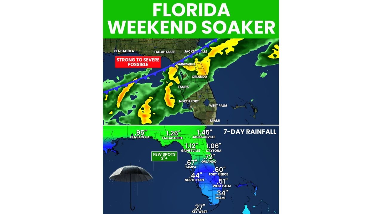
The 7-Day Rainfall Totals by City
The forecast rainfall map shows the heaviest totals concentrated across northern Florida where the front spends the most time, with totals decreasing southward through the peninsula:
- Jacksonville, Florida — 1.45 inches — highest total among major cities, reflecting the frontal passage timing across the northeast Florida corridor
- Tallahassee, Florida — 1.26 inches — Panhandle capital sees meaningful accumulation from the system
- Gainesville, Florida — 1.12 inches — north-central Florida inside the strongest part of the rainfall footprint
- Daytona Beach, Florida — 1.06 inches — Atlantic Coast city just over the 1-inch threshold
- Orlando, Florida — 0.72 inches — central Florida sees moderate accumulation as the front pushes south
- Tampa, Florida — 0.67 inches — Gulf Coast sees less than the east side of the state but still beneficial rainfall
- Fort Pierce, Florida — 0.60 inches — Treasure Coast on the lighter end of meaningful totals
- West Palm Beach, Florida — 0.51 inches — south Florida beginning to fall off from the main rainfall corridor
- North Port, Florida — 0.44 inches — southwest Florida sees lighter totals
- Miami, Florida — 0.34 inches — southern tip gets a fraction of what northern Florida receives
- Key West, Florida — 0.27 inches — minimal contribution at the southern extreme
- Pensacola, Florida — 0.95 inches — western Panhandle sees nearly an inch from the system’s western extent
A few isolated spots across northern Florida are forecast to exceed 2 inches — these would be locations that receive the heaviest embedded convective rainfall within the frontal passage zone.
The Strong to Severe Storm Component
The Strong to Severe Possible designation on the forecast graphic applies to the northern tier of Florida, including the Jacksonville, Gainesville and Tallahassee corridors, where the front will interact with the greatest atmospheric instability and wind energy aloft. The blue frontal boundary on the map tracks from northwest to southeast, with the orange and yellow radar returns showing where the heaviest storm activity is forecast to concentrate.
The severe threat is not a major outbreak scenario — but with greater wind aloft and atmospheric energy riding along the front, isolated strong to severe storms producing gusty winds, small hail and heavy rainfall are possible, particularly across:
- Jacksonville, Florida — northeast Florida faces the highest severe potential as the front arrives
- Gainesville, Florida — north-central Florida in the strong to severe possible zone
- Tallahassee, Florida — Panhandle capital within reach of the frontal severe threat
What This Weekend Is and Is Not
Forecasters are clear about the scope of this event. This is not an all-weekend rain event — meaning dry hours will exist alongside the wet ones, and outdoor plans are not completely canceled, just weather-aware. It is not a drought buster — Florida’s rainfall deficit going back to last summer is measured in multiple inches across most of the state, and a 1 to 1.5 inch event in north Florida and 0.5 to 0.7 inches in central Florida makes a contribution without closing the gap. But after a prolonged dry stretch, every drop matters.
The event is also not a statewide soaker — south Florida from West Palm Beach through Miami and Key West receives light amounts that barely register against the existing moisture deficit.
What to Watch This Weekend
- Saturday is the primary storm day as the front makes its initial push southward across northern Florida — outdoor events in Jacksonville, Gainesville and Tallahassee should have rain contingencies in place
- Sunday brings additional storm activity as the front continues southward through central Florida toward Tampa and Orlando
- Watch for updated severe weather outlooks through Friday as the front’s timing and instability profile come into sharper focus — the strong to severe designation could shift in coverage and intensity with additional model runs
- South Florida from Miami through Key West should not expect meaningful rain relief from this system — the primary rainfall corridor stays well to the north
WaldronNews.com will continue tracking Florida’s weekend frontal system and provide updates on severe weather potential, rainfall totals and storm timing as Saturday approaches.