
Red River Valley, Arklatex and Ozarks Face 3 to 4 Inch Destructive Hail as CAPE Exceeds 5000 J/kg and MCS Threatens 60 to 80 mph Winds After Dark
TEXARKANA, Texas — A destructive hail threat is developing across the Red River region, Arklatex and Ozarks today, with atmospheric conditions that rank among the most favorable for very large hail seen this spring. CAPE values may exceed 5000 to 6000 J/kg across the core threat zone — an extreme instability reading that, combined with steep lapse rates and a supportive Hail Growth Zone, creates the thermodynamic environment for hailstones reaching 3 to 4 inches in diameter. As storms grow upscale after dark, an MCS capable of 60 to 80 mph wind gusts and a few tornadoes threatens the Deep South tonight.
Why This Environment Produces Very Large Hail
The sounding analysis from the HRRR initialized at 14Z Tuesday April 28, valid at 21Z for the 33.14°N, 97.19°W location near the Red River corridor shows the atmospheric profile driving today’s extreme hail potential in precise detail.
CAPE of 5115 J/kg at the surface — an extraordinary instability value. For context, 2500 J/kg is considered a significant severe weather environment. Values exceeding 5000 J/kg place today’s setup in a category that is rare even across the southern Plains during peak severe weather season. This instability drives explosive updraft development strong enough to suspend very large hailstones aloft for extended periods while they grow through the Hail Growth Zone.
Steep lapse rates in both low and mid-levels — the temperature drop with altitude is sharp throughout the atmosphere, which accelerates updraft development and increases the buoyancy of rising parcels through the hail growth layer. The DCAPE of 1266 confirms the downdraft potential that will eventually bring large hail to the surface.
High Hail Growth Zone CAPE — the CAPE concentrated specifically between the 0°C and -20°C layer — the zone where supercooled water droplets freeze most efficiently onto growing hailstones — is very supportive of large stone development. Hailstones cycling through this layer in a strong updraft accumulate ice layers rapidly, growing to 3 and 4 inch sizes before the updraft can no longer support their weight.
Weak low-level shear with strong deep-layer shear — this kinematic combination is specifically favorable for large hail. Weak low-level shear helps maintain hailstones within the updraft core rather than throwing them out of the storm quickly, giving them more time to grow. Strong deep-layer shear supports long-lived supercells that can sustain hail production over extended periods and large distances. The Effective Shear of 60 knots and STP of 3.23 confirm a significant severe weather environment.
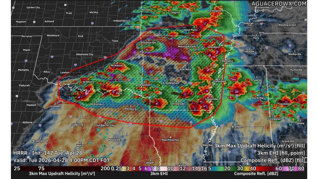
The HRRR Updraft Helicity and EHI Map
The HRRR 3km Max Updraft Helicity and EHI forecast valid Tuesday April 28 at 4 PM CDT shows the geographic footprint of the threat with clarity. The red outlined zone — the primary severe weather corridor — covers a large area from southeastern Oklahoma and northeastern Texas through the Arklatex, central Arkansas, the Ozarks and into the Mississippi Delta region.
The hatched pattern within the red zone marks areas where EHI (Energy Helicity Index) values of 3 or higher are forecast — a threshold associated with significant severe weather potential including both large hail and tornadoes. The highest EHI values — shown at 3 to 4 across the Fayetteville, Arkansas corridor and into the Memphis and Greenville, Mississippi area — indicate where the combined instability and helicity environment is most favorable for organized, long-lived supercells.
The 3km max updraft helicity fill across the red zone shows active rotating updraft signatures across the entire corridor from McAlester, Oklahoma through Paris and Pittsburg, Texas, De Queen and El Dorado, Arkansas and eastward toward Clarksdale and Greenville, Mississippi.
The Tornado Component — Two Separate Zones
The tornado threat today operates differently in two geographic areas:
Southeastern Oklahoma and Northeastern Texas: The tornado threat here is low-end and conditional, primarily dependent on boundary and storm interactions. The weaker low-level shear in this corridor suppresses organized mesocyclone development, meaning tornadoes require a specific triggering interaction — outflow boundary collision, storm merger or dryline interaction — rather than developing spontaneously from the background environment.
North and East — Stronger Low-Level Shear Zone: Further north and east across Arkansas and Missouri, low-level shear is stronger, supporting a greater tornado threat as storms interact with boundaries. The SARS sounding analogs on the sounding show 84% significant hail probability but 0% TOR probability from CAPE alone — confirming that the environment favors hail over tornadoes in the near-storm environment but that boundary interactions could change that rapidly.
The After-Dark MCS Threat — 60 to 80 mph Winds
As storms grow upscale around or just after dark, the character of the threat shifts dramatically. Individual supercells capable of large hail transition into an MCS — Mesoscale Convective System — that consolidates storm energy into a fast-moving, organized line. The MCS scenario brings:
- Wind gusts of 60 to 80 mph with the most organized line segments — capable of widespread tree damage, power outages and structural damage across a broad corridor
- A few tornadoes embedded within the line as it pushes through the Deep South tonight
- Heavy rainfall concentrated along the MCS track, with flash flooding possible in areas already wet from earlier convection
Cities in the Primary Threat Zone
3 to 4 inch hail corridor — Red River and Arklatex:
- Texarkana, Texas and Arkansas
- Paris, Texas
- McAlester, Oklahoma
- Ardmore, Oklahoma
- De Queen, Arkansas
- El Dorado, Arkansas
- Arkadelphia, Arkansas
Tornado and large hail — Ozarks and Arkansas:
- Fayetteville, Arkansas
- Jonesboro, Arkansas
- Little Rock, Arkansas
- West Plains, Missouri
- Mountain View, Arkansas
After-dark MCS wind threat — Deep South:
- Clarksdale, Mississippi
- Greenville, Mississippi
- Memphis, Tennessee
- Natchitoches, Louisiana
- Jasper, Texas
What to Do Before 4 PM Today
- Park all vehicles under cover immediately — 3 to 4 inch hail causes catastrophic vehicle damage and the storm corridor covers a large geographic area with limited warning time between storm initiation and hail arrival
- Residents across southeastern Oklahoma, northeastern Texas and the Arklatex should treat this as an active severe weather day from mid-afternoon onward
- The after-dark MCS means overnight preparedness is equally important — wind gusts of 60 to 80 mph arriving after sunset require the same shelter readiness as afternoon severe weather
- Keep weather alerts active through tonight — the threat transitions from hail-focused supercells in the afternoon to wind-focused MCS overnight, and both phases require active monitoring
WaldronNews.com will continue tracking today’s destructive hail threat and overnight MCS across the Red River region, Arklatex and Deep South and provide updates on hail reports, tornado warnings and wind damage as conditions evolve.