
Dallas, Fort Worth and Plano Face Level 4 Moderate Risk Upgrade With Isolated Softball-Sized Hail and Tornado Possible Between 4 and 7 PM
DALLAS, Texas — The Dallas-Fort Worth MetroPlex has been upgraded to a Level 4 out of 5 Moderate Risk for severe weather today — a significant escalation that reflects a concentrated zone of supercell formation taking shape across the metro this afternoon. The headline threat is large and destructive hail, with the most robust storms capable of producing baseball to softball-sized hail across the north side of the metro between 4 and 7 PM. An isolated tornado is also possible. Vehicles need to be inside a garage or beneath a carport by mid to late afternoon — parts of the metro will see very large to giant hail.
The Level 4 Upgrade — What It Means
A Level 4 Moderate Risk is the second-highest category on the five-level severe weather scale. It is issued when a widespread, organized severe weather event with significant hazards is expected — not possible, but expected — across a defined area. The upgrade from yesterday’s Level 3 Enhanced Risk reflects increasing model and observational confidence that the supercell environment across DFW today supports storms capable of the most destructive hail sizes.
The key atmospheric driver is locally extreme instability — the thunderstorm fuel that lofts water droplets high into the atmosphere where temperatures range between minus-22 and 14 degrees Fahrenheit. That temperature range is the Hail Growth Zone — the layer of the atmosphere where supercooled water droplets freeze onto growing hailstones most efficiently. When instability is extreme enough to drive strong updrafts through this zone repeatedly, hailstones grow to baseball and softball sizes before falling.
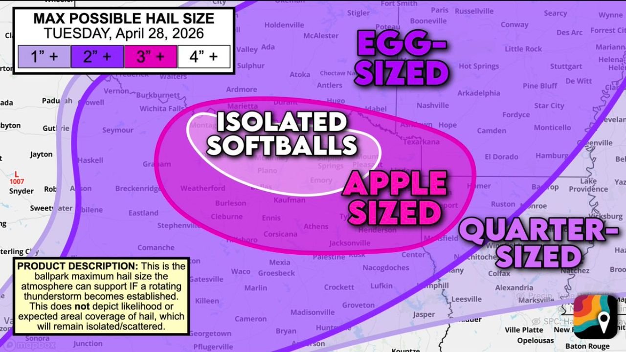
The Maximum Possible Hail Size by Zone
The Max Possible Hail Size map for Tuesday April 28 shows the maximum hail the atmosphere can support locally within supercells across each zone. This is not an areal coverage forecast — it shows what size is possible where hail does occur:
- Isolated Softballs (4+ inches) — the innermost white zone centered directly over the northern DFW metro, covering Plano, Frisco, McKinney, Denton and the Weatherford corridor. Softball-sized hail at 4 inches or larger causes catastrophic vehicle damage, shatters windows and penetrates roofs
- Apple-sized (3+ inches) — the pink zone expanding through the broader metro including Dallas, Fort Worth, Arlington, Burleson, Ennis and Corsicana
- Egg-sized (2+ inches) — reaching into Wichita Falls, Sherman, Sulphur, Antlers and the broader north Texas and southern Oklahoma corridor
- Quarter-sized (1+ inch) — the outer boundary extending through much of northeast Texas into Arkansas and Louisiana
The North Side of the Metro — Highest Hail Risk Between 4 and 7 PM
The north side of the Dallas-Fort Worth metro faces the concentrated supercell formation zone and carries the highest probability of seeing the largest hail between 4 and 7 PM. This is the evening commute window — the same timing problem that compounds vehicle damage risk when millions of cars are on exposed highways and surface roads during peak hail production hours.
Cities on the north side of the metro in the highest hail risk window:
- Plano, Texas
- Frisco, Texas
- McKinney, Texas
- Allen, Texas
- Denton, Texas
- Lewisville, Texas
- Flower Mound, Texas
- Grapevine, Texas
The Tornado Component
An isolated tornado remains possible alongside the dominant hail threat. In a Level 4 hail-focused environment, tornadoes tend to be secondary — but secondary does not mean impossible. Any discrete supercell that develops a clean, rotating mesocyclone before precipitation loading sets in can produce a brief tornado, particularly in the early stages of storm development before upscale growth begins.
Residents should treat any tornado warning issued between 4 and 7 PM with the same urgency as any other tornado event — the hail focus of the overall outbreak does not reduce the danger of an individual tornado warning.
What to Do Before 4 PM Today
- Park all vehicles inside a garage or under a carport right now — softball-sized hail falls at speeds that cause total-loss vehicle damage in seconds and there will be no time to relocate once the storm is on radar
- Do not be on the highway between 4 and 7 PM across the north DFW metro if avoidable — commuters caught in the open face hail damage and zero shelter options on the freeway
- If caught driving during a hailstorm, pull under a highway overpass or into a covered parking structure immediately — a vehicle is not protection from softball-sized hail
- Watch for tornado warnings alongside hail warnings and be prepared to shelter from both hazards simultaneously
- The north side of the metro from Denton through Plano and McKinney carries the highest risk and should be the most aggressive about vehicle and personal shelter preparation
WaldronNews.com will continue tracking Tuesday’s severe weather upgrade across the Dallas-Fort Worth MetroPlex and provide real-time updates on hail reports, tornado warnings and storm progression through the evening.