
Myrtle Beach and the South Carolina Coast Face the Biggest Rain Event in Months This Saturday as Gulf Moisture and Strong Upper Level Energy Combine
MYRTLE BEACH, South Carolina — Saturday is shaping up to be a completely different kind of rain day for the South Carolina coast, and residents from Georgetown to Florence to Lumberton need to understand why this system is not a repeat of the weak sprinkles that have disappointed the region over the last several months. A developing storm system pulling deep Gulf of Mexico moisture directly into the Carolinas, combined with upper level energy that holds together on arrival, creates the setup for a steady, all-day cold rain — the kind more typical of a winter storm than a May weekend. If Myrtle Beach picks up an inch or more Saturday, it would mark the first time since October that the city has seen that much rain in a single day.
Why Saturday’s Storm Is Nothing Like the Systems That Fizzled Recently
This is the question every South Carolina resident is rightfully asking after watching storm after storm fall apart before delivering meaningful rain. The answer comes down to two critical differences.
| Factor | Recent Systems | This Saturday |
|---|---|---|
| Upper level energy | Weakening on arrival | Stays strong through the Carolinas |
| Gulf moisture available | Very limited | Wide open — deep Gulf tap |
| Rain type | Scattered, hit-or-miss | Steady, organized, all-day |
| Expected impact | Sprinkles | Potentially biggest rain in months |
Recent systems came in with upper level energy already dying out as they approached the Carolinas, and they had almost nothing to work with in terms of moisture. Saturday’s system is the structural opposite. The energy holds together, and the Gulf of Mexico is fully available for the storm to pull from — meaning the atmosphere arrives loaded rather than dry.
Cities and Towns Directly in the Path of Saturday’s Rain
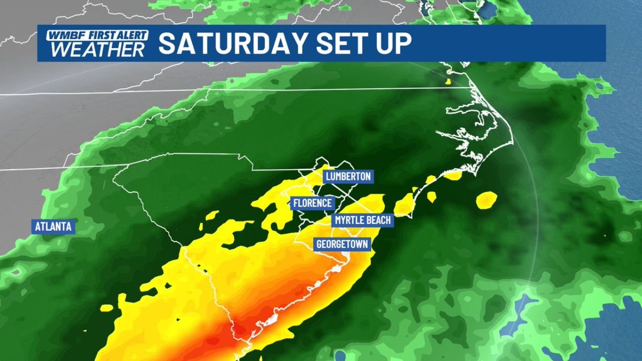
The radar setup map shows the heaviest precipitation corridor running directly along the South Carolina coast from Georgetown northward through Myrtle Beach, Florence, and Lumberton, North Carolina. The orange and red radar returns — indicating the most intense rainfall rates — are focused on this coastal strip, while yellow and green returns spread inland toward Atlanta and northward through the Carolinas.
| City | State | Expected Rain Intensity |
|---|---|---|
| Myrtle Beach | South Carolina | Heavy — orange/red core |
| Georgetown | South Carolina | Heavy — orange/red core |
| Florence | South Carolina | Moderate to heavy — yellow zone |
| Lumberton | North Carolina | Moderate — yellow zone |
| Atlanta | Georgia | Light to moderate — green fringe |
| Jacksonville | Florida | Light — eastern scatter |
The Gulf Moisture Pipeline Is What Makes Saturday Dangerous
Look at the broader setup and the story becomes clear immediately. The developing storm system is currently sitting over Texas, positioned near Dallas and Houston, with a heavy rain and storm core already active across the Gulf Coast from Houston toward New Orleans. The green arrows on the tracking map show Gulf moisture streaming northward and eastward directly into the Carolinas — a continuous feed of warm, humid air that the storm system will tap all day Saturday.
This is the pipeline that recent systems never had. When a storm pulls Gulf moisture in a steady stream, it does not run out of fuel. The rain does not stop after an hour. It persists — which is exactly the all-day soaking setup that forecasters are describing for Saturday across Myrtle Beach and the surrounding coast.
What One Inch of Rain in Myrtle Beach Actually Means
One inch of rain in a single day sounds simple. Here is what it actually represents for Myrtle Beach, South Carolina this Saturday.
| Context | Detail |
|---|---|
| Last time it happened | October 2024 — more than 6 months ago |
| How long the dry stretch has been | Multiple months of below-normal rainfall |
| Why this matters | Parched ground absorbs some rain but runoff increases quickly |
| Road flooding risk | Low-lying coastal roads near Georgetown and Myrtle Beach prone to ponding |
| Beach and outdoor event impact | All-day rain eliminates outdoor activity along the Grand Strand |
| Yard and garden benefit | First meaningful soil moisture recharge in months for coastal South Carolina |
Six-plus months without a single day of inch-or-more rainfall is a significant dry stretch for a coastal city that typically receives regular rainfall. Saturday represents the first genuine opportunity to break that drought in a meaningful way.
What to Watch Before Saturday Morning Arrives
- Storm system progression from Texas through Friday — if the system slows down or speeds up, Saturday’s peak rain timing for Myrtle Beach shifts accordingly
- Rainfall rate updates as the system approaches — the difference between a 0.5 inch day and a 1.5 inch day comes down to how efficiently the storm taps the Gulf moisture feed
- Flooding watches or advisories for Georgetown and Horry counties in South Carolina, where low-lying coastal geography makes even moderate rain totals capable of producing road flooding
- North Carolina impacts around Lumberton — the storm’s northern edge brings moderate rain to the southern North Carolina border counties as well
- Saturday morning timing — this looks like an all-day event, but the heaviest rates are most likely to be concentrated during a 4 to 6 hour window within the broader rain period
Anyone with outdoor plans along the Grand Strand or the South Carolina coast this Saturday should move them indoors. This is not a brief passing shower — the setup strongly favors steady, persistent rain lasting most of the day.
WaldronNews.com will continue tracking Saturday’s South Carolina rain event and provide updates as the storm system moves out of Texas and approaches the Carolinas through Friday.