
Marginal Risk Issued for Northern and Central Florida Saturday as 2.8 Million Residents Face Tornado, Hail and Wind Threat
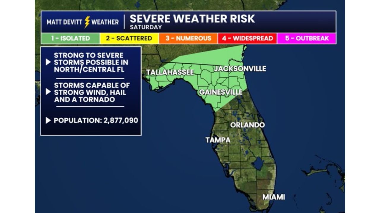
TALLAHASSEE, Florida — A Level 1 Marginal Risk for severe weather has been issued for northern and central Florida this Saturday, covering 2,877,090 residents across a corridor that includes Tallahassee, Jacksonville, and Gainesville. Storms capable of producing strong wind, hail, and a tornado are possible throughout the day, with forecasters noting that tornado potential cannot be ruled out given the stronger wind support available in the upper atmosphere. The Marginal Risk is also expected to expand into southern Florida for Sunday, meaning the threat does not end with Saturday for the state.
Every City Inside Saturday’s Severe Weather Risk Zone
| City | State | Inside Risk Zone | Threat |
|---|---|---|---|
| Tallahassee | Florida | Yes — core zone | Wind, hail, tornado possible |
| Jacksonville | Florida | Yes — core zone | Wind, hail, tornado possible |
| Gainesville | Florida | Yes — core zone | Wind, hail, tornado possible |
| Orlando | Florida | Southern edge | Monitored for expansion |
| Tampa | Florida | Outside Saturday zone | Sunday risk possible |
| Miami | Florida | Outside Saturday zone | Sunday risk possible |
What Level 1 Marginal Risk Actually Means for Residents
A lot of people see Level 1 and assume the threat is minor. That interpretation can be dangerous.
| Risk Level | What It Means |
|---|---|
| Level 1 Marginal | Severe storms are possible but not widespread. Isolated severe storms can still produce confirmed tornadoes, large hail, and damaging wind gusts. |
| Level 2 Slight | Scattered severe storms expected with more certainty over a broader area. |
| Level 3 Enhanced | Numerous severe storms expected across a well-defined corridor. |
| Level 4 Moderate | Widespread severe storms with significant tornado potential. |
| Level 5 Outbreak | Rare. Reserved for major outbreak events with violent tornado potential. |
A Marginal Risk does not mean weak storms. It means the coverage is expected to be isolated rather than widespread. A single tornado within a Marginal Risk area is fully consistent with the forecast. The 2,877,090 people inside this risk zone need to treat Saturday as an active weather day regardless of the level number.
Why Tornado Potential Is Specifically Called Out for This Event
The forecast language specifically notes that tornado potential cannot be ruled out because of stronger wind support aloft. This is the critical atmospheric detail separating Saturday from a typical garden variety storm day.
| Factor | What It Means Saturday |
|---|---|
| Strong wind support aloft | Winds at upper levels of the atmosphere are stronger than typical, which provides the shear needed to organize storms into rotating supercells |
| Rotating supercells | The storm type most likely to produce tornadoes, large hail, and damaging wind simultaneously |
| Northern Florida positioning | Closer to the upper level wind support, which is why north Florida carries more risk than central or south Florida Saturday |
| Central Florida inclusion | Far enough north to still catch some wind shear, though less favorable than the Tallahassee and Jacksonville corridor |
The mention of wind support aloft in the forecast discussion is a meteorologist’s way of saying the atmosphere has more tornado-producing potential than the Level 1 designation alone might suggest. When forecasters specifically call out that a tornado cannot be ruled out, residents in the risk zone should take that language seriously.
Saturday Into Sunday — How the Risk Evolves Across Florida
Saturday’s risk is focused on north and central Florida. Sunday brings a likely expansion southward toward Tampa, Orlando, and potentially Miami as the Marginal Risk zone shifts with the overall weather pattern. This means virtually the entire state of Florida faces some severe weather exposure across the two-day window.
| Day | Primary Risk Zone | Expected Risk Level |
|---|---|---|
| Saturday | North and central Florida — Tallahassee, Jacksonville, Gainesville | Level 1 Marginal |
| Sunday | Southern Florida expansion — Tampa, Orlando, Miami corridor | Level 1 Marginal expanding |
What Residents in Tallahassee, Jacksonville and Gainesville Must Do Before Saturday
- 2,877,090 people are inside this risk zone and every one of them should have a weather alert active on their phone before Saturday morning. The tornado cannot be ruled out language means warnings could be issued with limited lead time.
- Tallahassee residents sit at the western end of the risk corridor and should monitor morning storm development closely as any line pushing in from the Panhandle reaches the city first.
- Jacksonville residents on the northeastern end of the zone face potential for storms organizing along the coast where wind shear values are often locally enhanced compared to inland areas.
- Central Florida residents in Gainesville and the surrounding area are included in the risk zone and should not assume distance from the Panhandle provides safety. Isolated storms can develop anywhere within the green shading.
- Tampa and south Florida residents should monitor Sunday forecasts closely as the Marginal Risk expansion southward will become clearer by Saturday evening once forecasters have a better read on how the system evolves.
WaldronNews.com will continue tracking Saturday and Sunday severe weather risk across Florida and provide updates as storm initiation, tornado watches, and warning activity develop through the weekend.