
Florida Panhandle Faces Tornado Risk by 9AM Saturday as Storm Line Arrives 12 Hours Earlier Than Previously Forecast
PENSACOLA, Florida — A significant and fast-moving development in the Florida weekend forecast has shifted the severe weather timeline dramatically. The storm line targeting Florida this Saturday has pushed forward by nearly 12 full hours compared to forecasts from just a few days ago, meaning the Panhandle tornado threat now arrives around 9AM Saturday morning rather than the afternoon window residents may have been expecting. The line then pushes south and reaches the Orlando area by 5PM Saturday, with rotating storm potential greatest along the Gulf side and north Florida throughout the day before the system weakens as it moves further south.
How the Timeline Shifted and What It Means for Each Florida Region
The 12-hour forward shift is the most critical piece of information for anyone with Saturday plans across Florida. Morning tornado threats require earlier preparation than afternoon ones.
| Region | Arrival Time | Threat Level | Primary Hazard |
|---|---|---|---|
| Florida Panhandle | 9AM Saturday | Highest | Tornado risk, damaging wind |
| North Florida Gulf side | Late morning Saturday | Very elevated | Tornado potential, strong winds |
| North central Florida | Midday Saturday | Elevated | Organized line, wind gusts |
| Orlando area | 5PM Saturday | Moderate | Line passage, gusty winds |
| South Florida | Evening Saturday | Lower | Weakening system, limited threat |
The Panhandle at 9AM is the most urgent concern. Morning tornado events are historically more dangerous than afternoon ones because fewer people are monitoring weather, outdoor warning sirens are less likely to wake sleeping residents, and the visual cues that help spotters identify rotating storms are harder to see in early morning light.
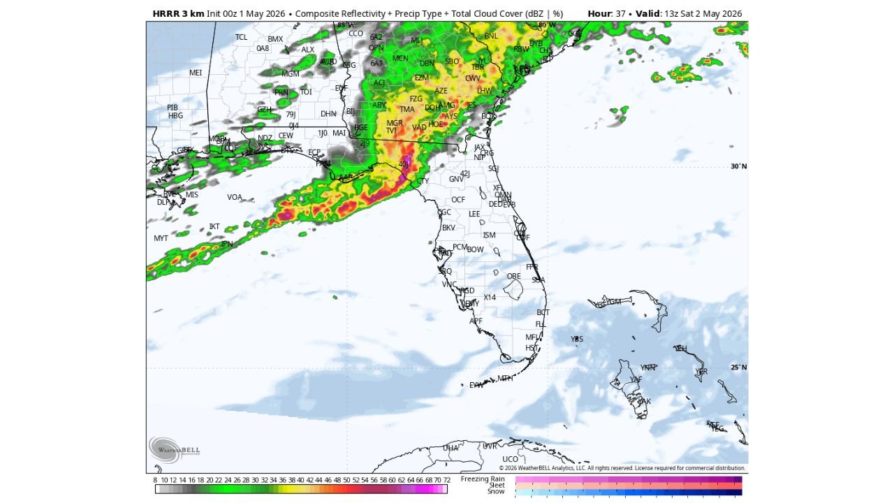
What the High Resolution Radar Forecast Shows at Each Time Stamp
The high resolution forecast radar images valid for Saturday tell a very specific story about how this line evolves across Florida throughout the day.
9AM Saturday — Panhandle. The radar image shows a well-organized and intense line of storms pushing into the western Florida Panhandle with deep red and yellow cores indicating the heaviest precipitation and strongest storm structure. The line is compact and organized, exactly the structure that produces tornadoes along its leading edge and within embedded supercells.
5PM Saturday — Central Florida. By afternoon the line has pushed southward into the Orlando corridor. The radar image shows a still-active but somewhat more elongated line across central Florida, with green and yellow returns indicating a system that has maintained coverage but spread out compared to the morning structure.
Overnight into Sunday — Weakening. The updraft helicity image, which measures rotating storm potential, shows the most significant spin values concentrated along the Panhandle and north Florida Gulf coast early in the event. By the time the system reaches central and south Florida, those rotation values weaken considerably, which is consistent with a line that produces its most dangerous storms in the morning hours across the north before losing organizational energy southward.
What Updraft Helicity Actually Means and Why It Matters Saturday
The third image showing updraft helicity is the tornado threat map in practical terms. Here is what it means in plain language.
| Term | Plain Language Explanation |
|---|---|
| Updraft helicity | A measurement of rotating air within a thunderstorm updraft. Higher values mean more rotation, which means higher tornado potential. |
| 2000 to 5000 meters level | The altitude range being measured. Rotation at this level indicates organized supercell structure capable of producing tornadoes. |
| Red and orange values on the map | Highest rotating storm potential, concentrated over the Panhandle and north Florida Gulf coast Saturday morning |
| Values weakening southward | The system loses its rotating potential as it tracks south, which is why Orlando and south Florida face a lesser tornado threat than the Panhandle |
The updraft helicity values on Saturday morning over the Panhandle are the clearest signal yet that this is not just a heavy rain event. Organized rotation within the storm line means tornado warnings are likely for portions of northwest Florida during the morning hours.
Cities Facing the Most Urgent Preparation Need Before Saturday Morning
| City | State | When to Be Ready | Key Threat |
|---|---|---|---|
| Pensacola | Florida | Before 8AM Saturday | Tornado, damaging wind |
| Panama City | Florida | Before 9AM Saturday | Tornado, damaging wind |
| Tallahassee | Florida | By 10AM Saturday | Organized line, tornado possible |
| Gainesville | Florida | Late morning Saturday | Line passage, wind gusts |
| Orlando | Florida | By 4PM Saturday | Line passage, gusty winds |
| Tampa Gulf side | Florida | Midday to early afternoon | Elevated rotation potential on Gulf coast |
What Florida Residents Must Do Before Saturday Morning
- Panhandle residents from Pensacola to Panama City need to be fully prepared before going to sleep Friday night. A 9AM tornado threat means warnings may be issued before many people have started their Saturday morning routine. Phone alerts must be turned on and audible overnight.
- Do not rely on outdoor sirens alone for a morning event. A phone weather alert with sound enabled is the only reliable way to receive a tornado warning while sleeping or indoors with windows closed.
- North Florida Gulf coast communities face the highest rotating storm potential based on the updraft helicity values. This corridor from the Panhandle down through the Nature Coast carries the most concentrated tornado risk of the entire event.
- Orlando area residents have more time but should finalize plans and check alerts by early afternoon Saturday. The 5PM line arrival means the evening hours could be impacted for anyone with outdoor plans.
- The 12-hour forward shift means old planning is outdated. Anyone who looked at this forecast earlier in the week and planned around an afternoon Panhandle threat needs to update that understanding immediately. The morning arrival changes everything about preparation timing.
- South Florida and the Miami corridor are not in the primary threat zone for this event based on the weakening system structure, but should monitor Saturday evening for any remnant activity.
WaldronNews.com will continue tracking Saturday’s Florida severe weather timeline and provide updates on tornado watches, warning issuances, and storm progression throughout Friday and Saturday.