
Southeast Severe Weather Risk Rises for Wednesday May 6 With Mississippi and Alabama in the Bullseye
JACKSON, Mississippi — Multiple forecasting tools are converging on a potential severe weather outbreak across the Southeast for Wednesday May 6, with the highest probability signals centering over Mississippi, Alabama, Arkansas, and Tennessee. This is a Day 7 forecast, meaning confidence is still building and details will sharpen considerably as the week progresses, but the agreement across several independent forecasting approaches is noteworthy enough to put the Southeast on early notice.
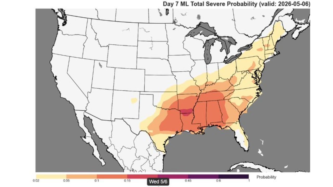
What Each Forecast Tool Is Showing for Wednesday May 6
Four separate forecasting approaches are all pointing at the same general area and the same general timing. That level of agreement at seven days out is meaningful.
| Forecast Tool | Peak Probability | Core Threat Zone |
|---|---|---|
| CSU-MLP Day 7 | 21.5% severe probability | Mississippi, Alabama, western Tennessee |
| NSSL ML Day 7 | 45 to 60% range | Mississippi, Arkansas, Alabama core |
| EPS FengWu analog | 25% maximum | Mississippi, Alabama, Tennessee, extending to Carolinas |
| CIPS 6 to 8 Day Analogs | 70 to 90% in parts of Texas, 50 to 70% across the Southeast | Broad coverage from Texas through the entire Southeast |
The spread between tools reflects the uncertainty that comes with a seven-day forecast. CSU-MLP sits at 21.5% while NSSL ML pushes into the 45 to 60% range for the core zone. That gap is normal at this lead time. What matters is that every tool independently identifies the same geographic bullseye across Mississippi and Alabama.
Cities and States Carrying the Highest Early Exposure
| City | State | Forecast Signal |
|---|---|---|
| Jackson | Mississippi | Core of highest probability on multiple tools |
| Hattiesburg | Mississippi | Inside elevated zone on all four tools |
| Birmingham | Alabama | Inside elevated zone on NSSL ML and EPS maps |
| Memphis | Tennessee | Northern edge of core zone |
| Little Rock | Arkansas | Western edge of elevated probability |
| Tupelo | Mississippi | Inside elevated zone |
| Montgomery | Alabama | Inside elevated zone on multiple tools |
| Nashville | Tennessee | Outer elevated zone |
| Charlotte | North Carolina | Outer brown zone on EPS FengWu map |
| Raleigh | North Carolina | Outer brown zone, northeastern fringe |
| New Orleans | Louisiana | Southern edge of elevated zone |
Why This Particular Setup Deserves Attention at Day 7
Most seven-day severe weather signals get ignored because individual model runs shift dramatically from day to day. This one is different for two reasons.
First, four independent tools are all highlighting the same area. CSU-MLP, CIPS analogs, NSSL ML, and EPS FengWu each use entirely different methodologies. When they converge on the same geography and the same day, the signal is more trustworthy than any single tool showing elevated probabilities alone.
Second, the CIPS 6 to 8 day analog map adds important historical context. Based on the top five analogs from 155 total matched atmospheric setups, 70 to 90% of similar historical patterns produced at least one severe weather report within 110 kilometers across portions of the southern Plains and Southeast. Texas shows the deepest red at 80 to 90%, while the Mississippi and Alabama corridor sits in the 50 to 70% range. That analog percentage is not a forecast probability. It is a statement that when the atmosphere has looked like this in the past, severe weather happened nearby in the majority of cases.
How the Threat Zone Breaks Down by Region
| Region | Signal Strength | Notes |
|---|---|---|
| Mississippi and Alabama core | Strongest across all tools | All four tools agree this is the bullseye |
| Arkansas and western Tennessee | Elevated on most tools | Secondary zone just west of the core |
| Louisiana Gulf Coast | Moderate on NSSL ML and EPS | Southern extension of the threat |
| Carolinas and Virginia | Outer zone on EPS FengWu | Elevated but less certain at this range |
| Texas and Oklahoma | Strong on CIPS analogs | Historical analog signal very high, Day 7 tools show moderate signal |
| Midwest and Great Lakes | Low | Outside the core threat corridor |
What to Watch as Wednesday Approaches
- Monday and Tuesday updates are the critical checkpoints. By Day 4 and Day 5, forecasting tools will have much higher confidence in the exact location, timing, and intensity of any severe weather outbreak. If the Mississippi and Alabama signal holds through the weekend, residents should begin preparing.
- Whether the threat zone shifts north or south as the week progresses. A slight northward shift would bring Tennessee and Kentucky more into focus. A southward shift would increase the Louisiana and southern Mississippi exposure.
- Tornado potential specifically within any Wednesday outbreak. The NSSL ML probability maps at this range do not distinguish between hail, wind, and tornado threats, but the geographic setup over Mississippi and Alabama is historically favorable for all three hazards when severe weather does develop.
- The Texas and Oklahoma signal on the CIPS analog map is worth watching separately. The 80 to 90% analog percentage over Texas suggests a broader multi-day pattern that could produce severe weather across the southern Plains in addition to the Southeast on Wednesday.
- Any watches or outlooks issued for Day 4 or Day 5 that confirm or modify the current signals heading into the first week of May.
Residents across Mississippi, Alabama, Arkansas, and Tennessee should have this Wednesday on their radar and monitor forecast updates closely through the weekend.
WaldronNews.com will continue tracking the developing Wednesday May 6 severe weather potential across the Southeast and provide updates as forecasting confidence increases through the week.