
Alabama Enjoys Clear and Cool Sunday Before Wednesday Night Severe Storm Threat Brings 1 to 2 Inches of Rain and Severe Thunderstorm Risk to Birmingham, Tuscaloosa, and Montgomery
BIRMINGHAM, Alabama — Most of Alabama is sitting under clear and cool conditions this Sunday evening with only a few small isolated showers near the Tennessee state line touching the northernmost counties around Huntsville and the Pulaski corridor. The radar at 6:48 PM CDT shows the activity well north of Birmingham and confined to a narrow band along the state border. The pleasant stretch continues through Monday and Tuesday before a cold front arrives Wednesday night into Thursday morning, bringing 1 to 2 inches of rain across most of Alabama and a severe thunderstorm risk covering roughly the western half of the state including Birmingham, Tuscaloosa, and Montgomery.
Tonight’s Radar — Where the Isolated Showers Are Right Now
The Huntsville radar image at 6:48 PM CDT shows exactly how limited tonight’s activity is across northern Alabama.
| Location | Radar Activity | Impact |
|---|---|---|
| Pulaski and Fayetteville, Tennessee | Yellow and green returns — light to moderate showers | Active but staying north of the state line |
| Bethel area near the Alabama border | Light green and yellow returns | Very isolated, minimal coverage |
| Huntsville metro | Essentially clear | No meaningful activity |
| Athens, Decatur, Madison | Clear | Dry and quiet |
| South Alabama — Birmingham southward | Completely clear | No activity whatsoever |
The isolated showers are hugging the Tennessee border and have no meaningful impact on the vast majority of Alabama tonight. This is a quiet evening across the state outside of a few rural northern counties.
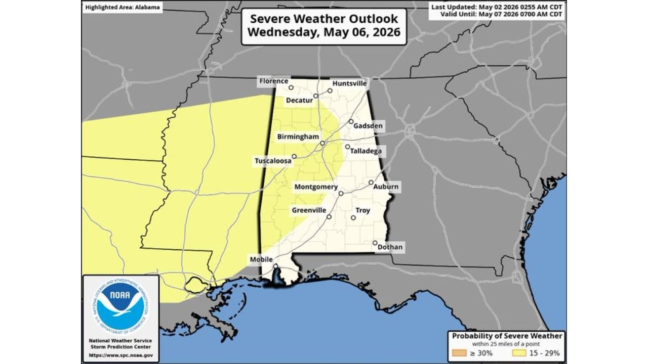
Wednesday Night Severe Weather Risk Across Alabama
The severe weather outlook valid Wednesday May 6 shows two distinct probability zones across the state.
| Zone | Probability | Cities Included |
|---|---|---|
| 30% or greater | Core western Alabama | Birmingham, Tuscaloosa, Montgomery, Talladega, Gadsden, Decatur, Huntsville northern fringe |
| 15 to 29% | Western fringe and Mississippi border | Florence, Mobile southern edge, western Alabama counties |
| Outside risk zone | Eastern Alabama | Auburn, Troy, Dothan, eastern third of state |
Birmingham sits squarely inside the 30% or greater zone, which is the highest probability on the current Wednesday outlook. The timing of Wednesday night into Thursday morning adds the darkness factor that makes this event require extra preparation since storms arriving after midnight catch residents asleep.
7-Day Rainfall Forecast Through Saturday May 9
The 7-day precipitation map ending Saturday May 9 at 8 PM shows Alabama receiving meaningful rainfall totals across the entire state from the Wednesday night event and any follow-on activity through the week.
| Region | Alabama | 7-Day Total Forecast |
|---|---|---|
| Northern Alabama | Huntsville, Florence, Decatur | 1.5 to 2.0 inches |
| Central Alabama | Birmingham, Tuscaloosa, Montgomery | 1.3 to 1.8 inches |
| Southern Alabama | Mobile, Dothan, Greenville | 0.2 to 1.0 inches |
| Eastern Alabama | Auburn, Gadsden, Talladega | 1.2 to 1.5 inches |
The heaviest totals across the broader region sit further north across Tennessee and Kentucky where the purple and red shading on the map indicates 1.8 to 2.7 inches over the same period. Alabama sits in the moderate accumulation zone with most of the state picking up 1 to 2 inches primarily from the Wednesday night event.
🌩️ Wednesday Night — Three Things That Make This Event Require Early Preparation
| Factor | Why It Matters |
|---|---|
| Nighttime timing | Storms arriving Wednesday night into Thursday morning mean most residents will be asleep. Phone alerts must be active and audible overnight Wednesday. |
| Western half focus | The 30% severe probability zone covers Birmingham, Tuscaloosa, and Montgomery simultaneously, putting the three largest cities in the western half of the state inside the highest risk area. |
| Wind and hail primary, tornado cannot be ruled out | The main threats are strong thunderstorm winds and hail, but a tornado or two cannot be excluded from the Wednesday night event based on current atmospheric data. |
What Alabama Residents Should Do Before Wednesday
- Birmingham, Tuscaloosa, and Montgomery residents inside the 30% severe probability zone should treat Wednesday night as an active severe weather preparation window starting Monday. Identifying shelter locations and ensuring phone alerts are active before Wednesday evening is the most important step.
- Wednesday night timing means sleeping through warnings is a real risk. Unlike an afternoon event where people are awake and monitoring, a midnight storm can produce a tornado warning that sits on a silenced phone for several minutes before anyone responds. Turn the volume up Wednesday night.
- Eastern Alabama from Auburn through Dothan sits outside the current severe weather risk zone. The Wednesday rain reaches these areas but organized severe storm coverage is expected primarily in the western corridor.
- Rain totals of 1 to 2 inches are meaningful but not flooding totals for most of Alabama. The concern Wednesday night is not rainfall volume but storm intensity, particularly the wind and hail potential within the strongest cells crossing the western half of the state.
- Enjoy the clear and pleasant Sunday through Tuesday window. Monday and Tuesday bring dry conditions before the pattern changes. Those two days represent the best outdoor weather opportunity of the week across Alabama.
WaldronNews.com will continue tracking Wednesday night’s Alabama severe weather threat and provide updates as the cold front timing and storm intensity become clearer through the week.