
Texas, Arkansas, Louisiana, and Mississippi Face Damaging Winds, Large Hail, and Tornadoes Tuesday May 5 and Wednesday May 6 as Severe Risk Shifts From Dallas to New Orleans
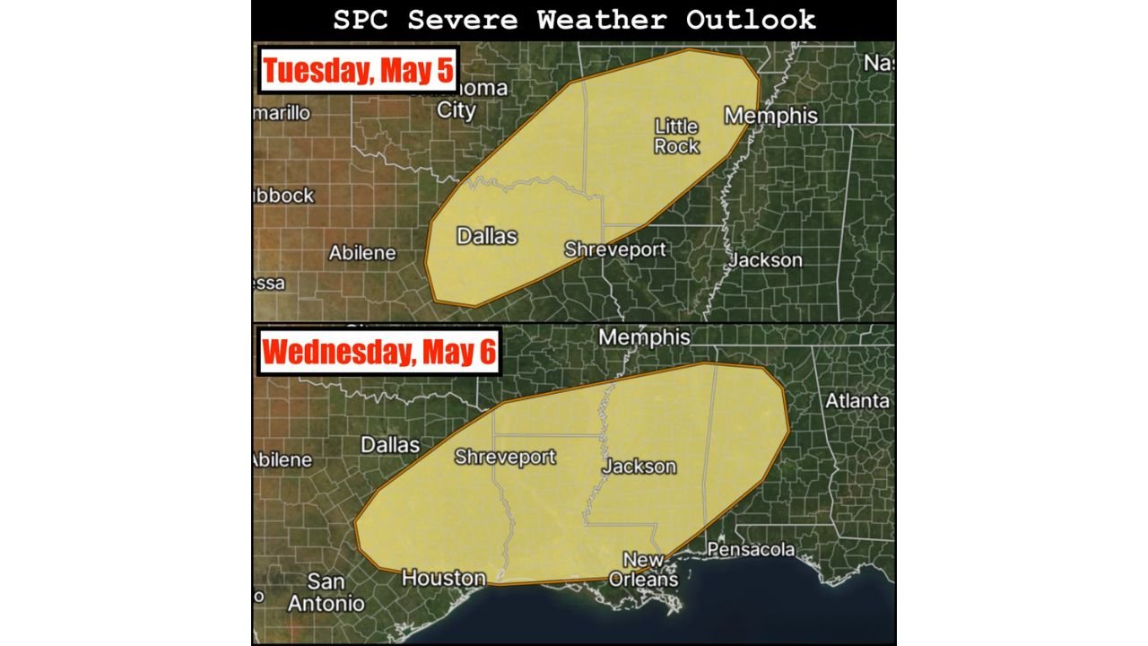
JACKSON, Mississippi — Severe weather risk areas are now introduced for both Tuesday May 5 and Wednesday May 6 across a corridor stretching from the southern Plains through the Deep South, with the threat zone shifting southward between the two days and targeting different communities on each. Mixed-mode convection within a strongly sheared warm sector ahead of a cold front is the setup both days, meaning the atmosphere supports multiple storm types simultaneously including organized lines, embedded supercells, and bow segments all capable of producing hazards. Damaging winds are the primary threat both days, but large hail and a few tornadoes also appear possible across both risk zones.
Tuesday vs Wednesday — How the Risk Zone Shifts South
| Detail | Tuesday May 5 | Wednesday May 6 |
|---|---|---|
| Northern anchor | Oklahoma City, Memphis | Memphis southern edge |
| Core cities | Dallas, Shreveport, Little Rock | Shreveport, Jackson, New Orleans |
| Southern extent | Northern Texas, northern Louisiana | Houston, New Orleans, Pensacola |
| Eastern edge | Jackson, Mississippi | Atlanta fringe, Pensacola |
| Geographic shift | Southern Plains to Mid-South | Deep South and Gulf Coast |
The southward shift between Tuesday and Wednesday means the storm system is tracking southeast as the cold front progresses, dropping the most active severe weather zone from the Oklahoma-Arkansas-Tennessee corridor on Tuesday into the Louisiana-Mississippi-Alabama corridor on Wednesday.
Cities Inside Each Day’s Severe Weather Risk Zone
| City | State | Tuesday Risk | Wednesday Risk |
|---|---|---|---|
| Oklahoma City | Oklahoma | Yes — northern edge | Outside zone |
| Dallas | Texas | Yes — core zone | Outside zone |
| Abilene | Texas | Yes — western edge | Outside zone |
| Shreveport | Louisiana | Yes — core zone | Yes — core zone |
| Little Rock | Arkansas | Yes — core zone | Outside zone |
| Memphis | Tennessee | Yes — northeastern anchor | Outside zone |
| Jackson | Mississippi | Yes — eastern edge | Yes — core zone |
| New Orleans | Louisiana | Outside zone | Yes — core zone |
| Houston | Texas | Outside zone | Yes — southern edge |
| San Antonio | Texas | Outside zone | Yes — far southern edge |
| Pensacola | Florida | Outside zone | Yes — eastern edge |
| Atlanta | Georgia | Outside zone | Eastern fringe |
| Nashville | Tennessee | Outside zone | Outside zone |
| Birmingham | Alabama | Outside zone | Outside zone |
Shreveport and Jackson are the two major cities that fall inside risk zones on both days, meaning they face consecutive days of severe weather exposure from Tuesday through Wednesday night.
🌩️ What Mixed-Mode Convection Means and Why It Is Dangerous
The forecast specifically calls out mixed-mode convection as the expected storm structure both days. This term deserves plain language explanation because it directly determines what kind of damage residents should prepare for.
| Storm Mode | What It Produces | Dominant Hazard |
|---|---|---|
| Discrete supercells | Isolated rotating storms, persistent updrafts | Tornadoes, very large hail |
| Squall line or QLCS | Long organized line of storms | Damaging straight-line winds across wide areas |
| Mixed-mode | Both supercells AND line segments active simultaneously | All hazards at once — wind, hail, AND tornadoes |
Mixed-mode convection is particularly dangerous because it combines the tornado and large hail threat from supercells with the widespread wind damage threat from organized lines. Communities in the risk zone cannot assume they only face one hazard. All three threats are active simultaneously within the same storm complex.
What a Strongly Sheared Warm Sector Means for Tuesday and Wednesday
| Term | Plain Language |
|---|---|
| Warm sector | The region of warm, moist air ahead of the cold front where instability is highest and storm fuel is most abundant |
| Strongly sheared | Wind speed and direction change dramatically with altitude, providing the rotational energy needed to organize storms into supercells |
| Mixed-mode in a strongly sheared warm sector | The combination creates an environment where both isolated supercells and organized squall lines can develop and sustain themselves simultaneously |
The strong shear signal is what elevates the tornado threat above what a typical wind-focused severe weather day would carry. Shear organizes rotating updrafts, and rotating updrafts produce tornadoes. With strong shear present both days, the tornado callout in the forecast is credible even though damaging winds remain the most widespread concern.
What Southern Plains and Deep South Residents Must Do Before Tuesday
- Dallas and north Texas residents face the first active window Tuesday as the cold front approaches from the west. The risk zone extends from the Oklahoma border down through the Metroplex and east toward Shreveport. Tuesday afternoon is the expected peak activity window for this corridor.
- Little Rock and central Arkansas sit inside Tuesday’s northeastern risk zone. The mixing of storm modes in this area means both rotating supercells and line segments are possible during Tuesday’s activity.
- Shreveport residents face back-to-back days inside severe weather risk zones. Tuesday brings the initial storm activity and Wednesday brings the follow-on threat as the front pushes south. Preparation cannot be relaxed after Tuesday’s storms clear.
- Jackson and southern Mississippi are on the eastern edge of Tuesday’s zone and move into the core of Wednesday’s zone. The window between events may be short and residents should remain in active monitoring mode from Tuesday afternoon through Wednesday night.
- New Orleans and Houston residents are outside Tuesday’s risk but sit inside Wednesday’s southern zone. A quiet Tuesday does not mean a safe Wednesday for these cities.
- Pensacola and the Florida Panhandle catch the eastern edge of Wednesday’s risk zone as the system reaches its southeasternmost extent. Residents here should monitor Wednesday’s storm progression closely starting Tuesday evening.
WaldronNews.com will continue tracking the Tuesday May 5 and Wednesday May 6 severe weather threat across the southern Plains and Deep South and provide updates as watches are issued and storm activity develops through both days.