
Colorado and the Rocky Mountain Region Face Uncertain but Potentially Impactful Spring Storm Tuesday Into Wednesday as Cold Front and Desert Southwest Trough Race to Phase Over Denver
DENVER, Colorado — A significant forecast uncertainty is developing over the Rocky Mountain region heading into next week, and the outcome depends entirely on how two separate atmospheric features come together over Colorado. A cold front approaching from the north late Monday and a trough of low pressure moving out of the desert Southwest into the Four Corners region late Monday into Tuesday are on a collision course over the Rockies. How they phase together, and where exactly that phasing occurs, will determine whether Denver and the surrounding region gets an impactful spring storm with meaningful rain and snow or a weaker system that produces scattered showers with far less punch.
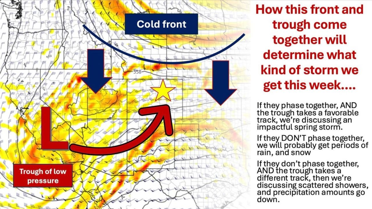
The Three Possible Outcomes Explained
This is genuinely a three-way fork in the forecast road, and each outcome produces a dramatically different week for Colorado.
| Scenario | What Has to Happen | What Colorado Gets |
|---|---|---|
| Favorable phase | Cold front and Southwest trough combine over the Four Corners on a favorable track | Impactful spring storm with significant rain and snow Monday night through Wednesday. Snow accumulation potential above 6,000 feet. Denver could receive as much snow as it has all winter long in a single event. |
| Unfavorable phase | Cold front and trough combine but the trough takes a track that does not optimize the storm structure | Still an impactful spring storm but the impacts are not as widespread. Some areas benefit significantly, others much less so. |
| No phase | The two features fail to combine meaningfully | Periods of rain and snow with the cold front, additional lift from the trough, but no organized impactful storm. Scattered showers and considerably lower precipitation totals across the board. |
The difference between the favorable phase scenario and the no-phase scenario is the difference between a major late-season snow event and a forgettable rainy Tuesday for Denver.
What Phasing Actually Means in Plain Weather Terms
The word phasing appears frequently in discussions about complex storm systems but rarely gets explained clearly.
| Term | Plain Language Explanation |
|---|---|
| Cold front | A boundary where cold air pushes south and east, forcing warm air upward. Brings rain, snow, and temperature drops on its own. |
| Trough of low pressure | An elongated area of low atmospheric pressure moving out of the desert Southwest. Carries energy and lift that can dramatically intensify a storm system when it combines with other features. |
| Phasing | When two separate atmospheric energy sources merge into a single, combined, more powerful storm system. Like two rivers joining — the combined flow is much stronger than either alone. |
| Favorable track | The trough moves on a path that allows it to merge with the cold front at the right time and place to maximize storm development over Colorado and the Rockies. |
| Unfavorable track | The trough merges too early, too late, or at the wrong location, reducing the storm’s potential even though both features are still present. |
| No phase | The two features pass through the region separately without meaningfully combining, producing weaker and less organized precipitation. |
🏔️ Why Above 6,000 Feet Matters Most in This Setup
The forecast specifically notes that the highest accumulation potential sits above 6,000 feet elevation regardless of which phasing scenario verifies.
| Elevation | Why It Matters |
|---|---|
| Above 6,000 feet | Temperatures are cold enough to support snow even in early May. Heavy snow accumulation possible in the favorable phase scenario. |
| Denver metro — 5,280 feet | Right at the borderline. Rain and snow mix likely in most scenarios. Heavy snow possible if temperatures drop far enough during the favorable phase. |
| Front Range foothills and mountains | Best accumulation zone. Communities from Boulder through Colorado Springs and into the mountain towns face the most significant snow potential. |
| Plains east of Denver | Mostly rain in all scenarios. Snow accumulation unlikely at lower elevations. |
The Model Disagreement Problem
The forecast discussion is unusually candid about the model situation and it deserves honest explanation.
| Model Signal | What It Shows | Reliability Assessment |
|---|---|---|
| One model | Extreme solution — Denver could receive as much snow as it has all winter long in a single event | Wildly inconsistent over the last 24 hours. Has been going in dramatically different directions run to run. Low confidence. |
| Other model | Weaker solution — rain and snow mainly Tuesday morning into Wednesday, highest accumulation above 6,000 feet | More conservative but also consistent with the no-phase or unfavorable phase scenarios. |
| Model blended average | Numbers have not moved much in the last 12 to 18 hours | Suggests forecast trends have not shifted meaningfully in either direction. Uncertainty remains genuinely unresolved. |
When the model ensemble average stops moving, it typically means the atmosphere itself has not yet committed to one solution. The features are still too far away from their critical interaction point for the models to clearly resolve which phasing scenario will verify.
What Colorado and Rocky Mountain Residents Should Watch Before Tuesday
- Monday evening is the critical observation window. As the cold front arrives from the north and the Southwest trough begins moving into the Four Corners, the first radar and surface observations will start revealing which phasing scenario is actually unfolding. Monday night updates will be far more confident than anything available this weekend.
- Above 6,000 feet communities from the foothills through the mountain towns should prepare for meaningful snow accumulation regardless of which scenario verifies. Even the weaker no-phase outcome produces snow above elevation.
- Denver metro residents should hold off on major commitments for Tuesday until the forecast resolves. The spread between a potentially historic late-season snow and a rainy Tuesday with little accumulation is too large to plan around confidently this weekend.
- The Tuesday morning into Wednesday window is when the main precipitation falls in all scenarios. Whatever form it takes, the most active period appears to be Tuesday through Wednesday morning rather than Monday.
- Watch for Monday afternoon forecast updates from local meteorologists who will have access to the first observational data showing how the cold front and Southwest trough are actually interacting as they approach Colorado.
WaldronNews.com will continue tracking the developing Colorado spring storm potential and provide updates as the cold front and Southwest trough approach the Four Corners region and model confidence improves through the weekend.