
Texas, Louisiana, Mississippi, and Alabama Face Slight Risk of Severe Weather Wednesday May 6 With Damaging Winds, Large Hail, and Tornadoes Possible From Houston and Shreveport to Jackson and Birmingham
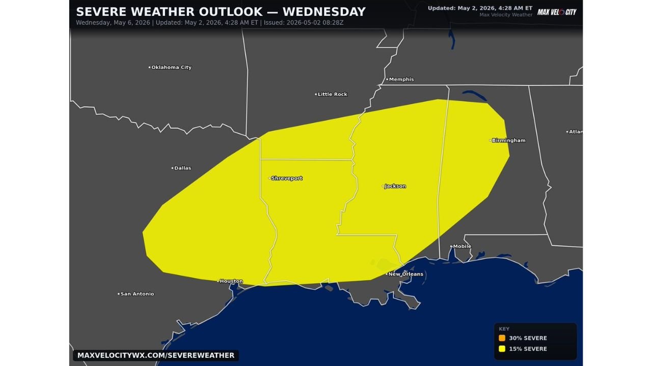
JACKSON, Mississippi — A large Day 5 Slight Risk of severe weather has been issued for Wednesday May 6 covering a broad corridor from eastern Texas through Louisiana, Mississippi, and into Alabama. The risk zone stretches from Houston and Shreveport on the western end through Jackson and New Orleans in the core and reaching Birmingham and Mobile on the eastern edge. All three major severe weather hazards are on the table for Wednesday: damaging winds, large hail, and tornadoes. This is a Slight Risk at Day 5, meaning confidence will increase significantly as the week progresses and the forecast sharpens toward the event.
Cities Inside Wednesday’s Severe Weather Risk Zone
| City | State | Inside Risk Zone | Probability Level |
|---|---|---|---|
| Shreveport | Louisiana | Yes — western core | 15% severe |
| Jackson | Mississippi | Yes — central core | 15% severe |
| New Orleans | Louisiana | Yes — southern core | 15% severe |
| Houston | Texas | Yes — southwestern edge | 15% severe |
| Mobile | Alabama | Yes — eastern edge | 15% severe |
| Birmingham | Alabama | Yes — northeastern edge | 15% severe |
| Little Rock | Arkansas | Yes — northern fringe | 15% severe |
| Memphis | Tennessee | Outside zone | Not included |
| Dallas | Texas | Outside zone | Not included |
| Oklahoma City | Oklahoma | Outside zone | Not included |
| Atlanta | Georgia | Outside zone | Not included |
The risk zone covers a large oval centered over Louisiana and Mississippi, which represent the bullseye of Wednesday’s severe weather potential based on the current Day 5 outlook.
What Slight Risk at Day 5 Means and Why It Will Change
| Term | What It Means |
|---|---|
| Day 5 outlook | Issued five days before the event. Confidence is lower than Day 1 or Day 2 but the signal is consistent enough to warrant an official risk designation. |
| Slight Risk | Level 2 on the 1 to 5 scale. Scattered severe storms expected. More than isolated activity but not the widespread coverage of an Enhanced or Moderate Risk. |
| 15% severe probability | Within any 25-mile radius point in the shaded zone, a 15% chance of at least one severe weather report. |
| What changes by Wednesday | As the event gets closer, the risk level could upgrade to Enhanced or higher if models show increasing confidence in storm organization and coverage. |
A Day 5 Slight Risk that covers this geographic area is a meaningful early signal. The atmosphere is already showing enough organization five days out to warrant an official designation, which suggests Wednesday is not a borderline event but a legitimate severe weather day in the making.
🌩️ Three Threats Across the Risk Zone Wednesday
| Threat | Expected Coverage | Most At Risk |
|---|---|---|
| Damaging winds | Most widespread hazard across the entire yellow zone | Everyone inside the risk zone from Houston to Birmingham |
| Large hail | Scattered within stronger storm cells | Central core over Louisiana and Mississippi |
| Tornadoes | Isolated but possible within supercell development | Core of the risk zone where shear and instability overlap most favorably |
The combination of all three hazards in a single day 5 Slight Risk is significant. It tells forecasters that the atmospheric setup is not just favorable for wind damage from squall lines but also supports supercell development capable of producing large hail and rotating storms.
What the Week Looks Like Leading Into Wednesday
Wednesday does not arrive in a vacuum. The broader pattern through the week is active and residents in the risk zone need to track multiple days of potential weather impacts.
| Day | Situation Across the Risk Zone |
|---|---|
| Sunday May 3 | Quiet and clear across most of the Deep South |
| Monday May 4 | Dry conditions continue, warmup begins |
| Tuesday May 5 | Separate severe weather risk across Texas and Arkansas ahead of Wednesday’s system |
| Wednesday May 6 | Main event — Slight Risk from Texas through Alabama |
| Thursday May 7 | System exits, drying trend begins |
Tuesday already carries its own severe weather risk across portions of Texas and Arkansas before Wednesday’s more southern-focused threat develops. Communities near Shreveport and Little Rock could face active weather on consecutive days.
What Louisiana, Mississippi, and Alabama Residents Must Do Before Wednesday
- Jackson and Shreveport residents sit in the center of Wednesday’s risk zone and should begin monitoring forecast updates daily through the week as confidence increases and the risk level potentially upgrades beyond Slight.
- Birmingham and Mobile residents on the eastern edge of the risk zone should not dismiss their exposure based on being at the fringe. The 15% severe probability extends fully into Alabama and all three hazards including tornadoes apply across the entire yellow zone.
- Houston and southeastern Texas residents are inside the southwestern edge of the risk zone. Wednesday’s system approaches from the northwest and storms will be developing and organizing as they track into the Houston corridor.
- New Orleans residents sit inside the southern core of the risk zone. Gulf moisture feeding into the system from the south adds fuel to Wednesday’s storm development and the New Orleans area has historically been vulnerable to severe weather in this type of Gulf moisture-loaded setup.
- Watch for upgrades Monday and Tuesday. A Day 5 Slight Risk frequently upgrades to Enhanced or higher as the event draws closer and model confidence builds. Any upgrade signals that Wednesday’s threat is becoming more significant than the current outlook shows.
- Tuesday’s separate severe weather risk across Texas and Arkansas means the region enters Wednesday already having dealt with one active storm day. Emergency management and residents should not let Tuesday’s activity create fatigue heading into the more southern Wednesday threat.
WaldronNews.com will continue tracking Wednesday May 6 severe weather risk across Texas, Louisiana, Mississippi, and Alabama and provide daily updates as the outlook evolves and confidence increases through the week.