
Arkansas Faces Classic Isolated Severe Weather Tuesday Evening as Rotating Storms Possible With Upper Level Winds, Low Level Jet, and CAPE Values Supporting Supercell Development
LITTLE ROCK, Arkansas — Tuesday is shaping up as a classic isolated severe weather day across Arkansas, with storms expected to mature during the evening hours as the atmospheric setup favors discrete supercell development rather than a large organized line. Upper level winds oriented more westerly support isolated storm mode, and a modest but present low level jet provides the rotational energy needed to spin up at least a few rotating storms. Not everyone in Arkansas will see severe weather Tuesday, but the signal is consistent enough that the state should be on alert for isolated severe storms by evening.
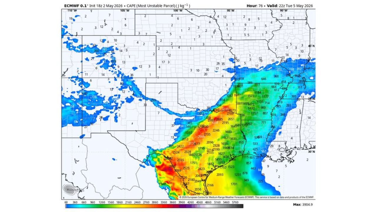
What the Four Atmospheric Maps Show for Tuesday Evening
The four model maps valid 10 PM Tuesday May 5 tell a layered story about why Arkansas sits in the crosshairs for isolated severe weather.
| Map | What It Shows | What It Means for Tuesday |
|---|---|---|
| Lightning flash density | Deep red and magenta returns concentrated over Arkansas and the Tennessee border corridor | Highest storm electrical activity focused directly over Arkansas Tuesday evening, confirming where the most intense storms are expected |
| 500mb height and wind speed | Orange and red upper level jet streak of 60 to 80 knots pushing over Arkansas from the southwest | Strong upper level winds providing wind shear and the divergence needed to support storm development and intensification |
| 850mb height and wind speed | Orange and red low level jet values of 30 to 48 knots pushing northward through Arkansas | The low level jet delivering warm moist air from the Gulf and providing the rotational shear needed for supercell and tornado development |
| CAPE — Most Unstable Parcel | Values of 1,300 to 2,500 joules per kilogram across Arkansas | Extremely high instability fuel available for storm updrafts Tuesday evening |
All four maps point at the same geography and the same time window. That level of agreement across independent atmospheric parameters is what gives the Tuesday Arkansas severe weather signal credibility at this range.
What Each Atmospheric Ingredient Does and Why It Matters Tuesday
| Ingredient | Value Tuesday Over Arkansas | What It Does |
|---|---|---|
| Upper level jet — 500mb | 60 to 80 knots | Provides wind shear between upper and lower atmosphere. Tilts storm updrafts, keeping them organized and persistent. |
| Low level jet — 850mb | 30 to 48 knots | Feeds warm moist Gulf air northward into Arkansas. Creates directional shear between surface and upper winds that spins storm updrafts into rotation. |
| CAPE | 1,300 to 2,500 J/kg | Convective Available Potential Energy — the fuel in the atmosphere available to power thunderstorm updrafts. Values above 1,000 J/kg support strong storms. Values above 2,000 J/kg support explosive storm development. |
| Westerly upper level wind orientation | Flow from the southwest at upper levels | Supports isolated discrete supercell mode rather than a large squall line. Individual storms can develop, persist, and rotate rather than merging into a single weaker line. |
| Modest low level jet | Present but not extreme | Enough rotational shear to support rotating storms. Not strong enough to force a massive squall line that would suppress supercell potential. |
Why Isolated Storm Mode Is Both Good and Bad News
The forecast specifically notes that Tuesday looks like isolated storm mode rather than a large organized line. This distinction matters significantly for how residents should prepare.
| Storm Mode | Coverage | Hazard Profile |
|---|---|---|
| Large squall line | Widespread — everyone in the path gets impacted | Wind is dominant hazard. Tornado risk lower. Hard to dodge. |
| Isolated supercells | Spotty — some areas hit hard, some miss entirely | All hazards active simultaneously. Tornado risk higher per storm. Some people dodge it completely. |
| Tuesday Arkansas setup | Isolated supercell mode | Tornado-capable rotating storms possible. High CAPE values support large hail. Some communities may see nothing while neighbors face a significant storm. |
The honest statement from the forecast is that some people might dodge it altogether. That is the nature of isolated severe weather. But the storms that do develop will be capable of producing significant hail, damaging winds, and tornadoes given the CAPE values and rotational shear present Tuesday evening.
Where the Lightning and Storm Activity Focuses Tuesday Evening
The lightning flash density map shows the highest electrical activity concentrated in two areas on Tuesday evening. The primary cluster sits over Arkansas and the Tennessee border region with deep red values indicating extremely high flash rates. A secondary area of active storms is visible across New Mexico and Arizona on the western side, but those are separate from the Arkansas event entirely.
| Area | Lightning Density Tuesday Evening | Interpretation |
|---|---|---|
| Arkansas and Tennessee border | Deep red and magenta — highest values on the map | Most intense storm activity of the evening concentrated here |
| Oklahoma and north Texas | Scattered blue and cyan | Lighter storm activity on the western edge of the system |
| New Mexico and Arizona | Separate activity | Unrelated western storm system |
| Mississippi and Alabama | Light activity on eastern fringe | Trailing edge of the system, less active than Arkansas |
What Arkansas Residents Must Do Before Tuesday Evening
- Little Rock and central Arkansas sit in the primary zone where isolated supercells are most likely to develop Tuesday evening. The high CAPE values and low level jet support are concentrated over the central Arkansas corridor based on the atmospheric maps.
- Evening timing means preparation must be done during the day. Storms maturing in the evening hours means the severe weather window opens roughly between 5 PM and 10 PM Tuesday. Have shelter plans identified and phone alerts active before leaving work or school Tuesday afternoon.
- Isolated storm mode means checking radar actively matters. Unlike a large squall line where everyone knows it is coming, isolated supercells can develop rapidly in specific areas while nearby communities stay dry. Actively monitoring radar Tuesday evening rather than relying solely on warnings provides extra lead time.
- The low level jet delivering rotational shear means any storm that develops Tuesday evening should be treated as tornado-capable until it proves otherwise. The atmospheric ingredients for rotation are present and modest low level jet values are sufficient to produce rotating updrafts in high CAPE environments.
- High CAPE values of 1,300 to 2,500 J/kg mean storm updrafts will be extremely powerful if storms develop. Large hail is a significant concern alongside tornado and wind hazards given the fuel available in the atmosphere Tuesday evening.
- Some areas will see nothing. Isolated storm mode means the coverage is limited. But being in an area that dodges Tuesday’s storms does not reduce the need for active monitoring — isolated supercells can develop and track into areas that appeared safe earlier in the afternoon.
WaldronNews.com will continue tracking Tuesday’s Arkansas severe weather potential and provide updates as storm initiation timing and specific storm tracks become clearer through the day Monday and into Tuesday.