
Missouri, Illinois, Indiana, and Kansas Face Severe Thunderstorm Line Monday Night Into Tuesday Morning as Storm Corridor Stretches From Kansas City to South Bend
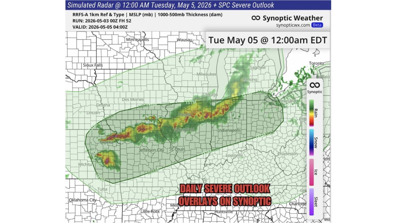
KANSAS CITY, Missouri — Evening model data is holding firm on a healthy line of severe thunderstorms pushing from Kansas City to South Bend during Monday night into Tuesday morning May 5, with the simulated radar valid at midnight Tuesday showing a well-organized and intense storm line stretching across Missouri, Illinois, and Indiana. The storm corridor shown on the outlook map places the most active and intense radar returns over a band running from Topeka and Kansas City eastward through Jefferson City, St. Louis, Peoria, Springfield, and Indianapolis before reaching the South Bend and Chicago corridor by early Tuesday morning.
Cities Inside the Monday Night Into Tuesday Morning Storm Corridor
| City | State | Inside Storm Line | Expected Timing |
|---|---|---|---|
| Topeka | Kansas | Yes — western anchor | Monday evening |
| Wichita | Kansas | Yes — southwestern edge | Monday evening |
| Kansas City | Missouri | Yes — western core | Monday night |
| Jefferson City | Missouri | Yes — core zone | Monday night |
| St. Louis | Missouri | Yes — core zone | Late Monday night |
| Springfield | Illinois | Yes — core zone | Late Monday night |
| Peoria | Illinois | Yes — core zone | Late Monday night to early Tuesday |
| Indianapolis | Indiana | Yes — eastern core | Early Tuesday morning |
| South Bend | Indiana | Yes — northeastern end | Early Tuesday morning |
| Chicago | Illinois | Yes — northern fringe | Early Tuesday morning |
| Milwaukee | Wisconsin | Northern fringe | Early Tuesday morning |
| Louisville | Kentucky | Southern edge | Late Monday night |
| Des Moines | Iowa | Northern edge | Monday night |
What the Simulated Radar Shows at Midnight Tuesday
The radar image valid Tuesday May 5 at 12:00 AM EDT shows a classic bow-shaped severe thunderstorm line with the most intense red and orange returns concentrated in a band running from Kansas eastward through central Missouri and into Illinois. The storm line has the organized linear structure that produces the most widespread damaging wind events, while embedded areas of deeper red indicate locally more intense cells within the line capable of producing larger hail and isolated tornado potential.
| Storm Feature | What It Indicates |
|---|---|
| Organized linear structure | Well-developed squall line with consistent forward motion — widespread severe wind threat along entire corridor |
| Embedded red cores over Missouri and Illinois | Locally more intense cells within the line — elevated hail and tornado potential at those specific locations |
| Bow shape | Classic signature of a rear-inflow jet pushing the line forward — associated with the most intense straight-line wind damage events |
| Extent from Kansas to South Bend | Storm line spans approximately 600 miles — a large and organized system that will not weaken quickly |
Three Threats Along the Monday Night Storm Line
| Threat | Coverage Along the Line | Highest Risk Area |
|---|---|---|
| Damaging straight-line winds | Most widespread threat along the entire storm corridor | Everyone from Kansas City through Indianapolis |
| Large hail | Embedded within the most intense cores | Central Missouri and central Illinois where red returns are deepest |
| Isolated tornadoes | Possible within supercell structures embedded in or ahead of the main line | Missouri and Illinois ahead of the main line passage |
The bow-shaped structure of the line is the key indicator for damaging wind potential. When a squall line develops a pronounced bow, it indicates a rear-inflow jet accelerating storm motion and concentrating wind energy along the leading edge of the system. Communities from Kansas City through St. Louis and across Illinois should expect powerful wind gusts as the bow segment passes Monday night.
What a Midnight Arrival Means for Residents
The timing of this storm line is one of its most dangerous characteristics. A system arriving between 10 PM and 2 AM local time catches most residents asleep, and the midnight window shown on the simulated radar for the Missouri and Illinois core zone is squarely in the most vulnerable overnight hours.
| Timing Factor | Impact on Safety |
|---|---|
| Midnight arrival for Missouri and Illinois | Most residents asleep when the line passes through |
| Early Tuesday morning for Indiana | 1 to 3 AM local time — still overnight, still high sleeping risk |
| Chicago and South Bend by early Tuesday | Pre-dawn hours, low awareness without active alerts |
| No visual warning cues at night | Cannot see approaching storms, wall clouds, or rotation in darkness |
| Phone alerts are the only reliable warning method | Silent or do not disturb modes on phones eliminate the only safety net |
What Missouri, Illinois, and Indiana Residents Must Do Before Monday Night
- Kansas City, Jefferson City, and St. Louis residents face the earliest arrival of the storm line Monday evening. Have shelter plans identified before going to bed Monday night. The most intense part of the line crosses Missouri during the overnight hours.
- Turn phone alerts to full volume before bed Monday night. This is the single most important action for every resident from Topeka to South Bend. A tornado or severe thunderstorm warning issued at midnight is useless on a silenced phone.
- Springfield and Peoria residents sit directly in the path of the most intense red cores visible on the simulated radar. These areas face elevated hail risk in addition to damaging winds as the embedded intense cells within the line pass through central Illinois.
- Indianapolis and South Bend residents should expect the storm line between 1 and 3 AM Tuesday morning. Setting a weather alert before midnight gives sufficient time to receive warnings as the line crosses Indiana.
- Secure outdoor items Monday evening before the storm arrives. A bow echo producing wind gusts in the 60 to 80 mph range will turn unsecured patio furniture, trampolines, and decorations into dangerous projectiles.
- Louisville and southern Iowa residents on the edges of the storm corridor still face meaningful severe weather risk. The fringe of a 600-mile storm line still produces damaging winds and hail even where storm intensity is lower than the core zone.
WaldronNews.com will continue tracking Monday night and Tuesday morning severe weather across Missouri, Illinois, Indiana, and Kansas and provide updates as the storm line develops and warning activity begins across the corridor.