
Significant Tornado Threat Escalates for Central and Northern Arkansas and Southeastern Oklahoma Tuesday Between 4 and 10 PM as Low-Level Shear Increases
LITTLE ROCK, Arkansas — The Tuesday, May 5 tornado threat across central and northern Arkansas and southeastern Oklahoma has escalated with the latest model data showing an uptick in low-level shear that directly increases the potential for significant tornadoes between 4 PM and 10 PM. Supercells are forecast to erupt across northern Arkansas by 4 PM before additional storm development fires southwest along the cold front into southeastern Oklahoma through the evening hours. Any dominant supercell that develops during this window carries the potential for an isolated significant tornado.
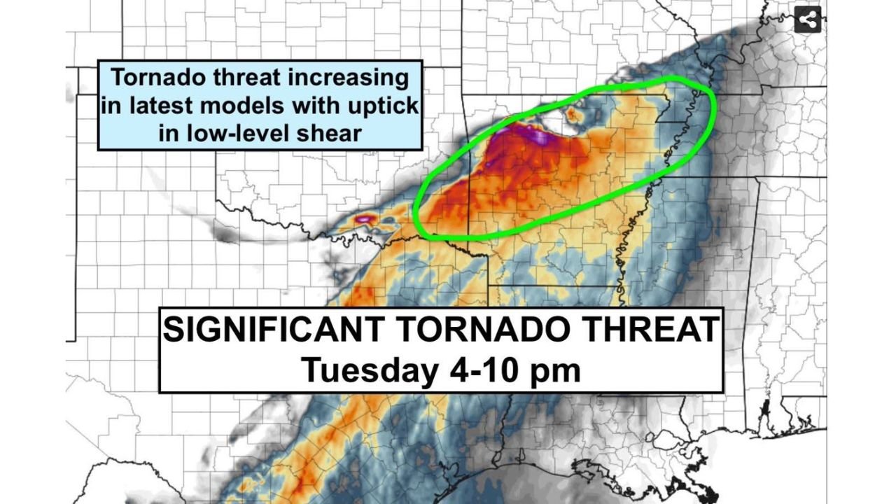
The Six-Hour Window That Matters Most
Tuesday 4 PM to 10 PM is the critical timeframe. This is not an all-day threat. Storms are expected to initiate in northern Arkansas around 4 PM and then expand southwest along the cold front boundary into southeastern Oklahoma as the evening progresses.
The timing means residents across northern and central Arkansas face their highest risk during the late afternoon commute hours, while southeastern Oklahoma communities see their peak threat push later into the evening hours after sunset.
Why the Threat Just Increased
Latest model runs have done something forecasters watch closely: they increased the low-level wind shear in the warm sector ahead of the system. Low-level shear is the primary atmospheric ingredient that determines whether a supercell produces tornadoes and how strong those tornadoes become.
The shear map shown in the image places the highest values, deep red and magenta shading indicating the most intense low-level wind fields, directly over the green-circled zone covering central and northern Arkansas. That concentration of extreme low-level shear in the same location where supercells are forecast to develop is why the significant tornado threat has been upgraded with this latest data.
Who Is Inside the Highest Risk Zone
Based on the green-circled area on the shear map, the core significant tornado threat corridor for Tuesday 4 to 10 PM covers:
- Little Rock and the central Arkansas corridor
- Batesville, Searcy and Conway in northern and central Arkansas
- Fort Smith area along the Oklahoma-Arkansas border
- Southeastern Oklahoma communities including the McAlester and Poteau region as storms develop along the cold front later in the evening
What Significant Tornado Means
A significant tornado is defined as EF2 or stronger on the Enhanced Fujita scale. EF2 tornadoes produce winds of 111 to 135 mph, enough to destroy mobile homes, snap large trees, damage well-constructed homes and overturn vehicles. EF3 and above causes catastrophic structural damage.
The phrase isolated significant tornado means the probability of a major outbreak is low, but a single long-track violent tornado from one dominant supercell is specifically on the table for this event.
Act Now, Not at 4 PM
The storm initiation time of 4 PM leaves very little margin to prepare once the day begins. Residents across Little Rock, Conway, Batesville and southeastern Oklahoma should:
- Identify a sturdy shelter location before leaving home Tuesday morning
- Keep weather alert apps active through the entire afternoon and evening
- Anyone working outdoors or in mobile homes across the risk zone should have an alternate shelter plan in place before 3 PM
- Do not assume that because Tuesday morning is quiet the threat has diminished. This is an afternoon initiation event and conditions will deteriorate rapidly once storms begin firing
WaldronNews.com will continue tracking Tuesday’s significant tornado threat across Arkansas and southeastern Oklahoma and will provide updated coverage as the 4 PM initiation window approaches.