
Missouri, Indiana, Arkansas, Mississippi and Louisiana Face Three Straight Days of Severe Weather With EF2 Tornadoes Possible Near Little Rock and Memphis Tuesday
KANSAS CITY, Missouri — A positively tilted trough combining with a surface cold front drifting across the middle of the country is generating three consecutive days of severe weather across the Central United States, with a Slight Risk in place each day from Monday, May 4 through Wednesday, May 6. Each day carries a distinct geographic footprint and a different primary hazard, shifting from the Midwest on Monday to Arkansas and Texas on Tuesday before dropping south into Mississippi, Louisiana and Houston on Wednesday.
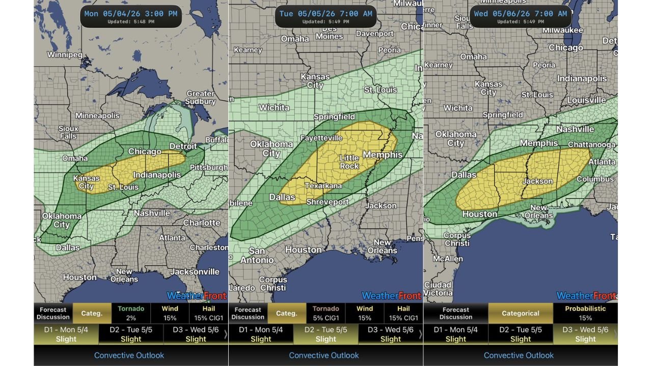
Monday May 4 — Kansas City, Indianapolis and Chicago
The Monday Slight Risk covers a corridor from Kansas City and St. Louis through Indianapolis and into Chicago and Detroit, with the yellow highest-risk zone centered over the Missouri-Illinois-Indiana corridor.
Monday’s hazard profile:
- Tornado: 2% — isolated tornado possible but low probability
- Wind: 15% — damaging gusts are the primary concern
- Hail: 15% CIG1 — significant hail possible with stronger cells, CIG1 flag means hail could reach larger sizes
Storms firing along the cold front Monday afternoon will be the main event for Kansas City, St. Louis and Indianapolis residents.
Tuesday May 5 — Little Rock, Memphis and Shreveport
Tuesday’s risk shifts southwest with the Slight Risk centering over Arkansas, northeastern Texas and western Tennessee, with the yellow zone covering Little Rock, Fayetteville, Texarkana, Shreveport and Memphis.
Tuesday’s hazard profile is significantly more serious than Monday:
- Tornado: 5% CIG1 — the CIG1 flag means any tornadoes that form carry EF2 potential
- Wind: 15% — damaging winds remain a threat
- Hail: 15% CIG1 — significant hail also flagged
The 5% CIG1 tornado probability is the critical number for Tuesday. It is a formal signal that EF2 or stronger tornadoes are specifically anticipated within the highest-risk zone covering central Arkansas through Memphis.
Wednesday May 6 — Jackson, Houston and New Orleans
Wednesday’s risk drops south and east with the Slight Risk shifting to cover Mississippi, Louisiana, Houston and extending toward Atlanta and Chattanooga. The yellow zone centers over Jackson, Mississippi with the green Marginal zone reaching Dallas, Nashville and Columbus, Georgia.
Wednesday’s probabilistic value sits at 15% for the overall severe weather threat, with damaging winds expected to be the dominant hazard as the cold front pushes through in a more linear storm mode.
Three Days at a Glance
| Day | Highest Risk Cities | Primary Hazard | Tornado Prob |
|---|---|---|---|
| Monday May 4 | Kansas City, Indianapolis, Chicago | Damaging wind | 2% |
| Tuesday May 5 | Little Rock, Memphis, Shreveport | EF2 tornado, hail | 5% CIG1 |
| Wednesday May 6 | Jackson, Houston, New Orleans | Damaging wind | 15% overall |
What Residents Should Know
Monday — Kansas City, St. Louis and Indianapolis should monitor storms through Monday afternoon and evening. Wind damage is the most likely hazard.
Tuesday — Little Rock, Conway, Fayetteville and Memphis face the most dangerous day of the three-day stretch. The EF2 tornado potential via CIG1 makes this the highest individual storm threat of the week. Shelter locations should be identified before Tuesday afternoon.
Wednesday — Jackson, Shreveport, Houston and New Orleans should expect a broad and fast-moving severe weather event with damaging winds as the dominant hazard across a wide geographic area.
WaldronNews.com will continue tracking all three days of this active severe weather pattern across the Central United States and will provide updated coverage for each event as it approaches.