
Mississippi, Louisiana and Alabama Face Large Hail and Tornadoes Wednesday as Supercell Composite Hits 20.4 and PDS Tornado Environment Locks In Across the Deep South
JACKSON, Mississippi — Wednesday afternoon and evening is shaping up as a genuinely dangerous severe weather period across Mississippi, Louisiana and Alabama, with supercells expected to develop and take advantage of an environment where the Supercell Composite reaches 20.4, a PDS TOR hazard flag is active and CAPE values at the lowest 0 degrees Celsius level reach 15,777 J/kg. While messy storm mode and weak low-level shear early in the day could limit the most significant tornado threat, any storm that matures and stays discrete through the afternoon and evening hours will be capable of large hail and tornadoes.
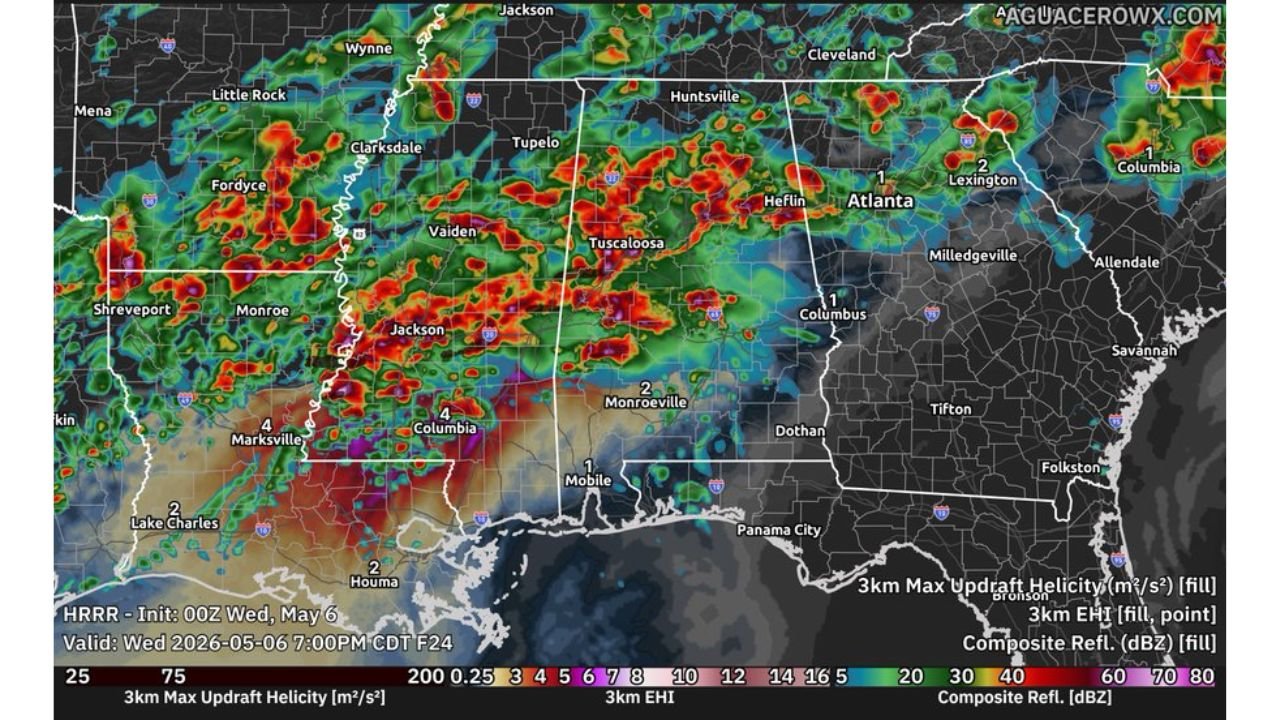
What the Radar Simulation Shows at 7 PM Wednesday
The HRRR simulation valid Wednesday, May 6 at 7:00 PM CDT shows a chaotic and widespread storm field across the entire Deep South corridor. The heaviest and most intense returns, orange and red reflectivity indicating 60 to 80 dBZ, are concentrated across:
- Central and southern Mississippi near Jackson, Columbia and Vaiden
- Western Alabama through Tuscaloosa and Monroeville
- Northern Louisiana near Shreveport and Monroe
- Southern Louisiana near Marksville and Lake Charles, where EHI values of 4 are plotted, indicating a high-energy helicity environment favorable for rotating storms
The storm field is not clean or discrete at this hour. Multiple clusters are firing simultaneously, which reflects the messy storm mode concern forecasters have flagged for this event.
The Sounding Data — A Dangerous Profile
A sounding valid Thursday, May 7 at 00z over 31.31°N, 90.61°W in southern Mississippi reveals one of the most extreme atmospheric profiles seen this week:
- Surface CAPE: 2,836 J/kg with forecast CAPE reaching 2,644 J/kg
- 0°C level CAPE: 15,777 J/kg — an extraordinarily high value representing enormous energy available through the hail growth zone
- Storm-Relative Helicity: 360 m²/s² — sufficient for supercell tornado development
- Supercell Composite: 20.4 — near the upper end of what this parameter produces, confirming an extremely favorable supercell environment
- STP (fix): 4.7 — well above the threshold for significant tornado potential
- SHIP: 1.5 — significant hail parameter confirming large hail is a primary threat
- Critical Angle: 62 degrees — within the favorable range for tornado-producing supercells
- SARS: 73% TOR match — the sounding analog system matches this profile to tornado-producing supercell environments 73 percent of the time
- Hazard flag: PDS TOR — Particularly Dangerous Situation Tornado environment
The PDS TOR designation is not issued casually. It specifically flags an environment where violent tornadoes are possible if storms can organize properly.
The Key Limiting Factor
Despite the extreme sounding values, two factors could limit the worst-case scenario Wednesday:
Weak low-level shear early in the day means storms initiating in the morning and midday hours may struggle to produce significant tornadoes before the environment fully destabilizes in the afternoon.
Messy storm mode — when too many storms fire simultaneously, they compete for instability and interfere with each other, preventing individual supercells from reaching their full potential. The radar simulation already shows this concern playing out across Mississippi and Alabama by 7 PM.
If a single dominant supercell can mature and stay isolated from the broader storm field, the PDS TOR environment and STP of 4.7 create conditions for a significant and potentially violent tornado.
Cities That Need to Be Weather Aware Wednesday
- Jackson, Columbia and Vaiden, Mississippi — directly under the heaviest simulated storm activity and inside the highest-risk sounding environment
- Tuscaloosa and Monroeville, Alabama — intense radar returns and EHI values indicate rotating storm potential
- Marksville and Lake Charles, Louisiana — EHI of 4 plotted directly over these areas on the simulation map
- Shreveport and Monroe, Louisiana — active storm coverage in the northern Louisiana corridor
- Mobile, Alabama — sits near the southern edge of the active storm zone
WaldronNews.com will continue tracking Wednesday’s Deep South severe weather threat across Mississippi, Louisiana and Alabama and will provide updated coverage as storms develop through the afternoon and evening hours.