
Charlotte, Atlanta and Chattanooga Face a Few Strong Thunderstorms Thursday With Beneficial Rain Expected Across the Carolinas and Georgia
CHARLOTTE, North Carolina — Thursday is shaping up as a day worth watching across the Carolinas, Georgia and Tennessee, not as a major severe weather outbreak but as a setup where warm and unstable air could allow a couple of thunderstorms to become strong if they can get organized. The bigger story for many drought-affected communities is simply the rain itself, which will be welcome regardless of storm intensity.
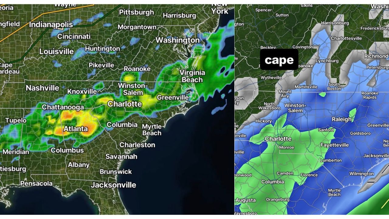
What the Instability Map Shows
The CAPE map for Thursday shows instability building across a focused zone:
Highest CAPE — Green Shading: Covers Charlotte, Monroe, the South Carolina Piedmont and Columbia, where instability values are sufficient to support strong thunderstorm updrafts if storms can initiate and tap into the unstable air
Moderate CAPE — Blue Shading: Spreads across Raleigh, Fayetteville, Winston-Salem, Roanoke and Charlottesville, where instability is present but less concentrated, meaning storm development is less certain and intensity would be lower
Minimal CAPE — Gray: Virginia and West Virginia north of the primary instability zone, where storm development is unlikely Thursday
Where Storms Are Already Active
The current radar image shows an active band of showers and thunderstorms already working through the region, with the heaviest returns concentrated near Atlanta and Chattanooga in orange and yellow, indicating moderate to locally heavy rainfall. The storm corridor stretches northeast through Charlotte and into Winston-Salem and Greenville, North Carolina, with lighter green shading pushing toward Washington D.C. and Virginia Beach.
This activity is the precursor to Thursday’s more organized potential as the system continues lifting northeast through the region.
The Honest Forecast
This is not a day to panic over but it is one to stay aware of. The text makes the situation clear: not a widespread or major event, but if a storm can mature and stay isolated over the Charlotte metro, Columbia or Atlanta area where CAPE values are highest, it could become strong to briefly severe.
The more meaningful impact Thursday for communities like Charlotte, Fayetteville and Columbia is the beneficial rainfall arriving with this system, which has been desperately needed across drought-affected portions of North Carolina and South Carolina.
Keep an eye on radar Thursday afternoon. No major preparations needed but a weather alert app running in the background is worth having given the instability present across the Charlotte and South Carolina Piedmont corridor.
WaldronNews.com will continue tracking Thursday’s storm potential across North Carolina, South Carolina and Georgia and will provide updates as the day approaches.