
Wednesday Tornado Threat Sharpens as Mississippi and Alabama Enter a 50 Percent Probability Core With the Highest Confidence Zone Tightening Over the Deep South for May 6
JACKSON, Mississippi — The Wednesday, May 6 tornado threat has sharpened significantly with a Monday morning forecast update placing Mississippi and Alabama inside a yellow-shaded 50 percent tornado probability core, a notable upgrade from earlier outlooks that showed only a 40 percent maximum. The highest confidence zone has tightened and shifted slightly east compared to previous forecasts, now centering directly over the Mississippi-Alabama border region for the period from Wednesday evening through early Thursday morning.
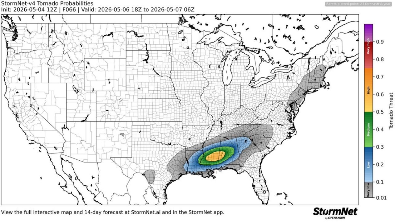
How the Probability Zones Break Down
The tornado probability map valid Wednesday May 6 18z through Thursday May 7 06z shows four distinct concentric zones tightening toward a well-defined core:
Yellow Core — approximately 50% tornado probability The highest confidence zone sits directly over central Mississippi into western Alabama. This is where the forecast has the greatest certainty that tornado development occurs during the Wednesday evening window. Jackson, Mississippi sits at or near the edge of this zone.
Green Ring — 40% probability Expands outward from the yellow core across a broader swath of Mississippi, Alabama and into Tennessee. Cities including Tupelo, Mississippi, Birmingham, Alabama and Memphis, Tennessee fall within this band.
Blue Zone — 20 to 30% probability Covers a wide area from Louisiana and eastern Texas through Alabama and into Georgia, representing a meaningful but lower tornado threat across the broader Deep South region.
Outer Gray Zone — very low probability Extends across much of the southeastern United States including portions of Georgia, Florida and the Carolinas.
A separate small low probability zone appears over southern Texas, disconnected from the main threat area.
What Has Changed Since the Previous Forecast
The earlier tornado probability map issued Sunday showed a green-shaded maximum of 40 to 50 percent centered over Mississippi and Louisiana. This updated Monday morning forecast shows:
- The core has shifted slightly northeast, now centered more over central Mississippi into Alabama rather than the Louisiana-Mississippi border
- The yellow shading reaching 50 percent represents an increase in model confidence compared to the previous outlook
- The geographic footprint of the highest-risk zone has tightened, meaning forecasters are gaining confidence in where exactly the worst threat will occur
That kind of tightening and confidence increase at two days out is significant. It means the models are converging on a solution rather than spreading the risk across a broader uncertain zone.
The Overnight Timing Problem Remains
The valid period of Wednesday 18z through Thursday 06z again places the most dangerous window during Wednesday evening through overnight hours across Mississippi and Alabama. This is the same nocturnal timing concern raised in earlier coverage and it has not changed.
Residents across Jackson, Hattiesburg, Meridian, Tupelo and Birmingham need to be awake and alert Wednesday night, not just Wednesday afternoon. A battery-powered weather radio is not optional for this event given the overnight valid window.
Confidence Is Still Building
This is the second consecutive tornado probability forecast update showing the Mississippi-Alabama corridor as the core target zone. Every additional model run that confirms the same geography increases the reliability of the forecast. Residents across central Mississippi and western Alabama should now treat Wednesday as a confirmed high-threat tornado day and finalize all preparations before Wednesday morning.
WaldronNews.com will continue tracking the Wednesday tornado threat across Mississippi and Alabama and will provide updated coverage as the event window approaches.