
Louisiana, Mississippi and Alabama Face Another Round of Storms Thursday and Friday as a Frontal Line Pushes Along the Upper Gulf Coast With a 15 Percent Tornado Probability
NEW ORLEANS, Louisiana — Another frontal system is pushing into the Southeast by Thursday and Friday, bringing a fresh round of storms along the upper Gulf Coast through Louisiana, Mississippi and Alabama. A formal severe weather probability zone with a 15 percent tornado probability core is already drawn over southern Mississippi and Alabama, and a stalling front could mean prolonged rain and storm chances linger through the end of the week for communities that have already seen active weather earlier in the week.
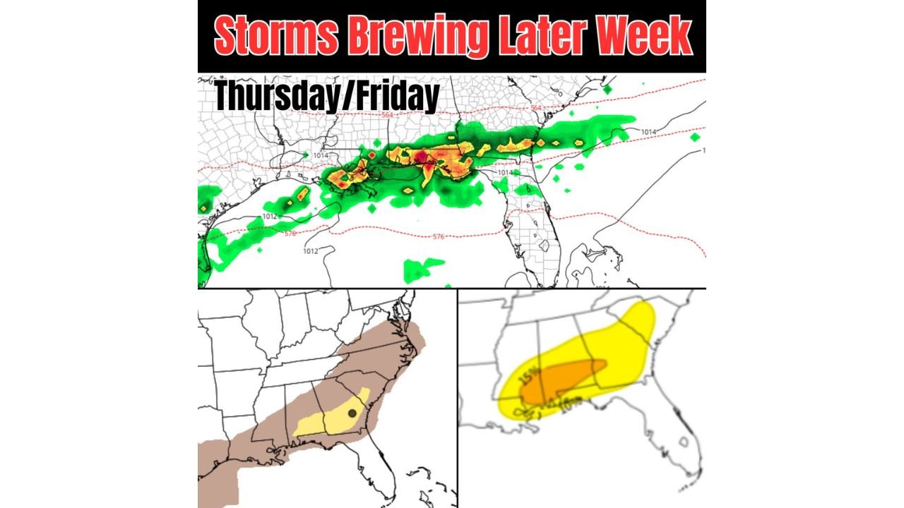
What Thursday and Friday Look Like
The radar simulation for Thursday and Friday shows a solid line of showers and thunderstorms pushing across the Gulf South, with the heaviest and most intense returns concentrated in orange and red across a corridor from Louisiana through southern Mississippi, Alabama and into the Florida Panhandle. The frontal line is well-organized and moving southeast toward the Gulf Coast.
Whether this system pushes far enough south into Florida or stalls out before reaching the peninsula remains the key uncertainty. A stalling front would mean repeated rounds of heavy rain for New Orleans, Mobile and Pensacola over multiple days rather than a single quick passage.
The Severe Weather Probability
Two probability maps are shown for the Thursday-Friday timeframe:
Left map — General severe weather probability: A broad brown zone covers North Carolina, South Carolina, Georgia and northern Florida, indicating a low but non-zero severe weather threat across the broader Southeast. A yellow zone with a black dot, indicating the highest probability within the area, sits over central Georgia and South Carolina, suggesting that is where the best organized storm potential exists Thursday.
Right map — Tornado probability: A 15 percent tornado probability core sits in orange shading directly over southern Mississippi and Alabama, with a broader yellow zone extending across Louisiana, Mississippi, Alabama and the Florida Panhandle. The 15 percent zone represents a meaningful tornado threat, not a marginal one, for communities along the upper Gulf Coast heading into the end of the week.
Cities sitting inside or near the tornado probability zone:
- New Orleans, Louisiana
- Biloxi and Hattiesburg, Mississippi
- Mobile, Alabama
- Pensacola, Florida
The Stalling Front Question
How far south the frontal boundary pushes and where it stalls will determine the full impact of this system. If the front stalls over southern Louisiana and Mississippi, those communities face multiple rounds of heavy rain and repeated storm chances through the weekend. If it pushes all the way into Florida, the storm window moves through more quickly.
Either way, New Orleans, Biloxi, Mobile and Pensacola should expect an active end to the week with storm chances continuing beyond the initial frontal passage.
WaldronNews.com will continue tracking this developing Gulf Coast storm threat for Thursday and Friday and will provide updates as the frontal timing and stall point become clearer.