
Central Arkansas and Southeastern Oklahoma Face EF2 Tornado Risk Tuesday as 5 Percent Tornado Probability Issued With Damaging Winds and Large Hail Also Threatening the Region
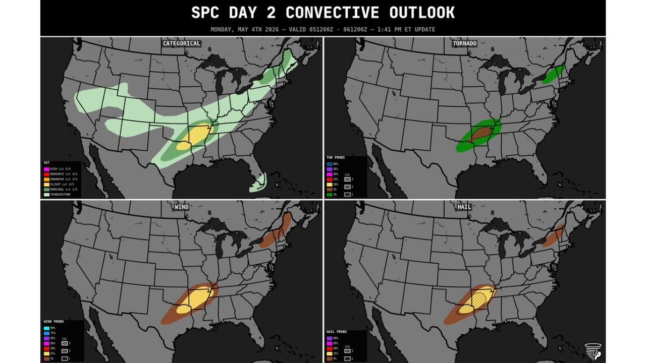
LITTLE ROCK, Arkansas — Tuesday’s severe weather outlook has been formally upgraded with tornado probabilities reaching 5 percent across central Arkansas and far southeastern Oklahoma, and a CIG1 corridor now exists within the risk zone meaning any tornadoes that form carry the potential to reach EF2 strength. The Day 2 outlook issued Monday, May 4 at 1:41 PM ET places central Arkansas inside a Slight Risk with all three severe hazard types, tornadoes, damaging winds and large hail, explicitly on the table for Tuesday.
The Four Hazard Maps
Categorical Risk: A Slight Risk Level 2 sits over central Arkansas and southeastern Oklahoma, surrounded by a broader Marginal Risk zone extending from Texas through Tennessee. The Slight Risk zone is compact but well-defined, centered directly over the area where supercell development is most favored Tuesday afternoon.
Tornado Probability: A 5 percent tornado probability zone with hatching covers central Arkansas, indicating the CIG1 corridor where EF2 or stronger tornadoes are possible. CIG1, or conditional intensity guidance, means the atmospheric profile supports violent tornado potential if discrete supercells develop and stay isolated. A separate small tornado probability area appears over the Great Lakes region, unrelated to the Arkansas threat.
Wind Probability: The wind map shows the broadest threat area of the four panels. A yellow high-probability wind zone covers central Arkansas through northern Louisiana and into Mississippi, with orange shading expanding outward. This is the largest footprint on any of the four maps, reflecting that damaging straight-line winds have the widest geographic reach Tuesday regardless of storm mode.
Hail Probability: A concentrated yellow hatched hail zone sits over central Arkansas, with hatching indicating significant hail of 2 inches or larger is possible with the strongest supercells. Orange hail probability shading extends outward across Oklahoma, Louisiana and Mississippi.
What CIG1 and the Hatching Mean
Two specific signals in this outlook deserve attention from Arkansas residents:
The hatching on the tornado map means forecasters believe EF2 or stronger tornadoes are possible within that zone, not just weak spin-up tornadoes. An EF2 produces winds of 111 to 135 mph, enough to destroy mobile homes completely, snap large trees and cause major structural damage to well-built homes.
The CIG1 corridor indicates the wind profile is favorable for tornadoes to intensify significantly once they form. A storm that produces a brief weak tornado in a CIG1 environment can rapidly intensify to EF2 if it maintains its structure.
Cities in the Risk Zone
Based on the Slight Risk and tornado probability placement:
- Little Rock — inside the Slight Risk and near the tornado probability zone
- Conway and Russellville — central Arkansas corridor at elevated risk
- Fort Smith — near the Oklahoma-Arkansas border zone
- Southeastern Oklahoma communities near McAlester and Poteau
The Bottom Line for Tuesday
This is a focused but genuinely dangerous setup for central Arkansas. The combination of a 5 percent tornado probability, EF2 potential via the CIG1 flag, significant hail hatching and the broadest wind probability zone of the four maps means all three hazard types are real and forecasters have enough confidence to formally upgrade the outlook two days in advance.
Residents across Little Rock, Conway, Russellville and Fort Smith should finalize shelter plans and have weather alert systems active before Tuesday afternoon.
WaldronNews.com will continue tracking Tuesday’s Arkansas severe weather threat and will provide updated coverage as the event approaches.