
Virginia and Maryland Face Two Rounds of Rain Wednesday as Washington D.C., Fairfax and Montgomery County See 0.1 to 1 Inch Totals With Afternoon Storms Possible
WASHINGTON, D.C. — Wednesday brings two distinct rounds of wet weather to Virginia, Maryland and Washington D.C., separated by a midday break before scattered and potentially heavier storms arrive in the afternoon. Outdoor plans across Fairfax, Montgomery County, Prince George’s County and the D.C. metro should account for rain from the morning commute through the evening hours.
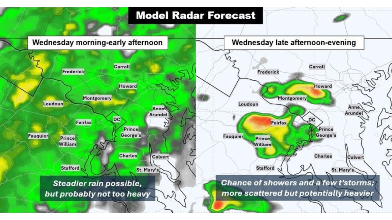
Round One: 7 AM to 1 PM
The morning round is the steadier but lighter of the two. Steady rain is expected across the region with totals mainly in the 0.1 to 0.25 inch range. This is not a heavy rainfall event in the morning but it will be persistent and consistent enough to affect commuters across Loudoun, Fairfax, Prince William, Montgomery and Howard Counties.
The radar simulation for Wednesday morning into early afternoon shows broad green coverage across the entire metro area, confirming widespread light to moderate rain through midday.
Round Two: 4 PM Into the Evening
The afternoon and evening round is where the bigger variability comes in. Scattered showers and thunderstorms are possible from around 4 PM onward, and these storms have the potential to produce:
- 0.5 to 1.0 inch of rain in areas that get hit directly
- Downpours with brief periods of very heavy rainfall
- Gusty winds with any stronger cells
The severe threat appears fairly low for this event but some storms could be sharp and locally impactful. The scattered nature of the afternoon activity means some areas could receive very little while others get close to an inch, making precise totals difficult to nail down ahead of time.
The radar simulation for Wednesday late afternoon and evening shows intense orange and red returns concentrated near Fairfax, Prince William, D.C. and Prince George’s County, confirming where the heaviest storm potential is currently modeled.
Thursday Remains Uncertain
Confidence drops considerably for Thursday. Showers could linger into the day or slip south of the region entirely. Anyone with outdoor plans Thursday should check updated forecasts closer to the day as the Thursday picture will not become clear until Wednesday evening at the earliest.
WaldronNews.com will continue tracking Wednesday’s rain and storm potential across Virginia, Maryland and Washington D.C. and will provide updates as the afternoon storm window approaches.