
Arkansas Tornado Threat Peaks Tuesday Evening as Warm Front and Outflow Boundary Combine Near Little Rock, Conway and Jonesboro to Boost Low-Level Spin
LITTLE ROCK, Arkansas — Tuesday’s tornado threat across Arkansas is entering its most critical window, with a warm front reinforced by an outflow boundary from last night’s storms now combining to enhance low-level spin across a hatched tornado probability zone covering the entire state from Fort Smith and Mena east through Little Rock, Conway, Jonesboro and Memphis, Tennessee. One or two tornadoes are considered the most likely outcome if sufficient instability builds despite stubborn cloud cover that remains the single biggest limiting factor for the event.
The Setup Right Now
Two atmospheric boundaries are overlapping across northern and central Arkansas, and their interaction is what forecasters are watching most closely this evening.
The warm front is lifting northward across the state, pulling Gulf moisture and instability northward into the storm development zone. Layered on top of that is an outflow boundary, the remnant of cold air exhaust from last night’s storm activity, which is reinforcing the warm front and amplifying the low-level wind shear along its axis.
When a warm front and an outflow boundary stack together like this, the result is enhanced low-level spin along a focused corridor. Any supercell that encounters this boundary intersection carries a significantly elevated tornado potential compared to a storm developing in a uniform environment.
The Cloud Cover Problem
The tornado risk will be maximized in northern Arkansas only if sufficient CAPE builds through the afternoon despite persistent cloud cover that has been slowing destabilization. CAPE, or Convective Available Potential Energy, is the thermodynamic fuel that powers storm updrafts. Without adequate CAPE, even a strong wind shear environment cannot produce violent storms.
If cloud cover breaks enough to allow surface heating this afternoon, the instability needed to supercharge the wind shear environment will arrive and tornado potential rises sharply. If clouds remain stubborn through the afternoon, storms will be working with less fuel and the tornado threat stays limited to isolated and less intense events.
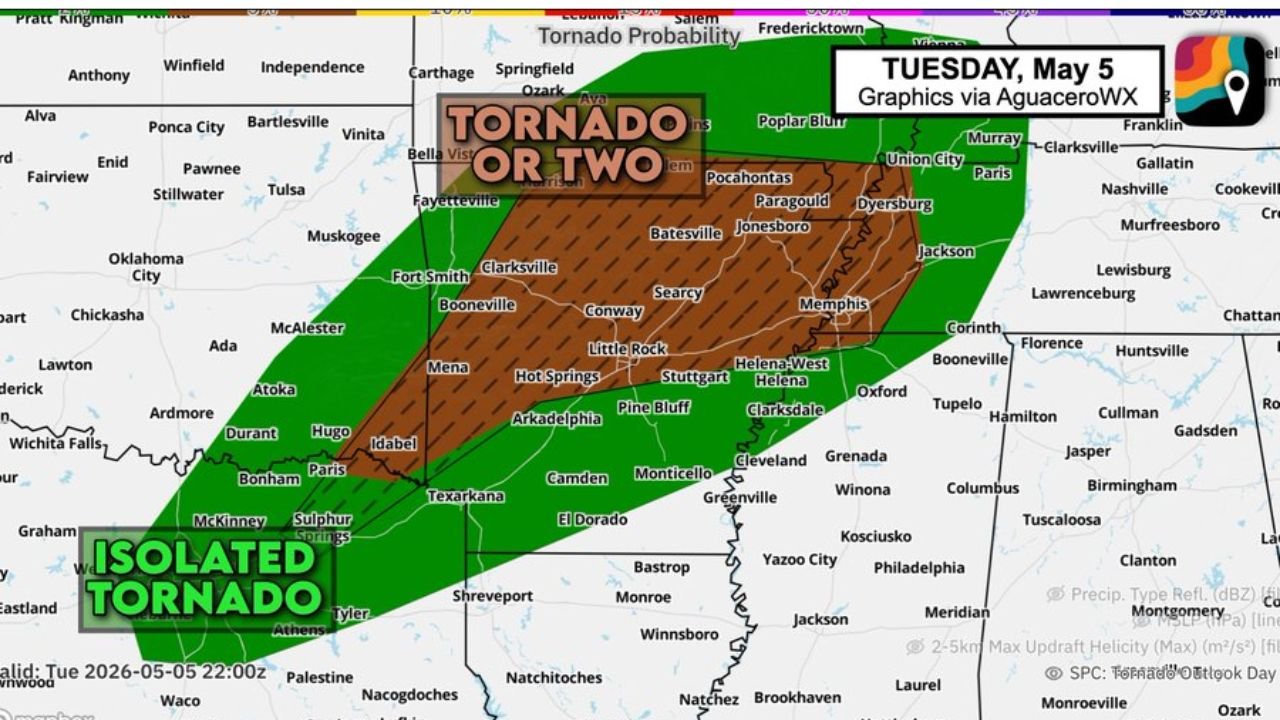
The Risk Zone
The tornado probability map for Tuesday, May 5 shows a large hatched zone indicating EF2 or stronger tornado potential stretching across most of Arkansas into western Tennessee. The hatching covers:
- Fayetteville, Fort Smith, Clarksville and Booneville in northwestern Arkansas
- Conway, Searcy, Little Rock and Hot Springs in central Arkansas
- Batesville, Jonesboro and Paragould in northeastern Arkansas
- Memphis, Tennessee on the eastern edge of the risk zone
An isolated tornado zone extends further southwest into southeastern Oklahoma and northeastern Texas outside the hatched area.
What Residents Across Arkansas Need to Know Right Now
The boundary interaction near Conway, Clarksville and the Arkansas River Valley represents the highest-risk intersection point for tornado development this evening. Any storm that fires along or near the outflow boundary and warm front in this area will have access to the enhanced low-level spin that produces the strongest tornadoes.
- Little Rock, Conway and Searcy residents should be shelter-ready before 5 PM and keep weather alerts active through the evening
- Jonesboro and Batesville in northeastern Arkansas remain in the hatched EF2+ zone through the event window
- Do not assume the quiet afternoon means the threat has passed. The most dangerous storms typically develop in the late afternoon and early evening hours in this type of setup
WaldronNews.com will continue tracking Tuesday’s Arkansas tornado threat through the evening and will provide updates as storm initiation begins across the state.