
Arkansas Faces Greatest Hail and Tornado Threat Tuesday Evening as Little Rock, Batesville and Arkadelphia Enter High-Risk Zone With STP of 4.0 and TGR Hazard Flag Active
LITTLE ROCK, Arkansas — The most dangerous window of Tuesday’s Arkansas severe weather event is arriving this evening, with the greatest hail and tornado threat concentrated in a red-circled zone covering Little Rock, Batesville, Arkadelphia and the Memphis corridor as intense supercells develop in a moderately unstable and highly sheared environment. A formal Slight Risk covers Arkansas and Tennessee on today’s outlook while a broader Marginal Risk extends from Dallas through Nashville, but the core threat is tightly focused on central and northern Arkansas through 10 PM CDT.
The Current Outlook
The Tuesday, May 5 severe weather outlook updated at 7:52 AM CDT shows:
- Slight Risk centered over Little Rock, Memphis and Springfield, covering the corridor where the greatest supercell potential exists
- Marginal Risk extending from Dallas and Oklahoma City northeast through Nashville and Knoxville
- A separate small Marginal Risk zone near Miami and Key West, Florida
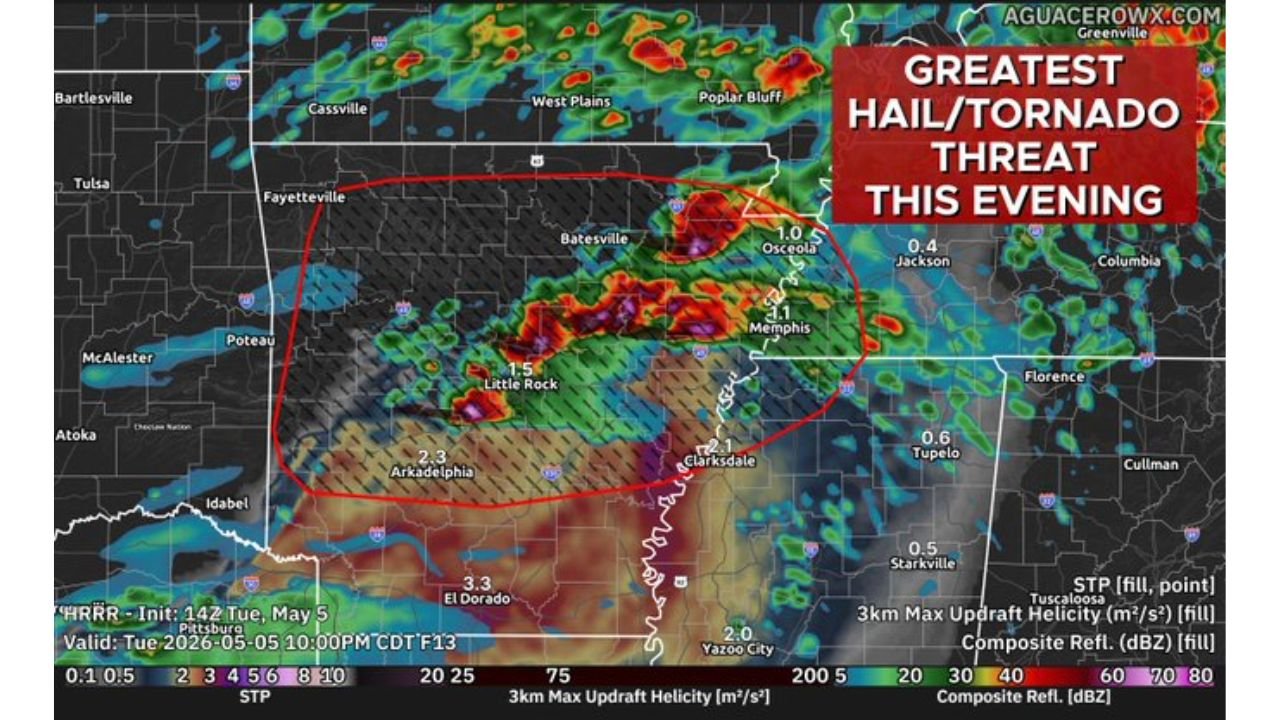
What the Evening Radar Simulation Shows
The HRRR simulation valid Tuesday, May 5 at 10:00 PM CDT places the most intense storm activity in a well-defined red oval covering:
- Little Rock with STP values of 1.5 plotted directly over the city
- Arkadelphia with STP of 2.3 — the highest value on the map
- El Dorado area showing STP of 3.3
- Batesville on the northern edge of the highest updraft helicity zone
- Clarksdale, Mississippi with STP of 2.3 just east of the Arkansas border
STP, or Significant Tornado Parameter, measures the combined atmospheric ingredients for significant tornado production. Values above 1.0 indicate a favorable tornado environment. Values of 2 to 3 represent a high-end environment. The 3.3 reading near El Dorado is particularly notable.
The Sounding Data
A sounding valid Wednesday, May 6 at 01z over 34.5°N, 93.4°W in western Arkansas confirms the dangerous profile:
- Surface CAPE: 1,837 J/kg, mixed-layer CAPE at 2,197 J/kg
- 0°C level CAPE: 13,648 J/kg — massive energy in the hail growth zone
- Storm-Relative Helicity: 387 m²/s² — strong rotational potential
- STP: 4.0 — high-end significant tornado environment
- Critical Angle: 69 degrees — favorable for tornado-producing supercells
- SARS: 66% TOR match with 197 loose analogs — majority of historical matches produced tornadoes
- Hazard flag: TGR — Tornado, Giant Hail, Rotating supercell
- DCAPE: 725 — strong downdraft energy supporting damaging wind gusts
Two Factors That Could Limit the Threat
Despite the dangerous numbers, two atmospheric conditions could suppress the worst-case scenario:
Warm 700 mb temperatures earlier in the evening create a cap that inhibits storm updraft growth, potentially delaying or limiting the most organized supercell development until later tonight.
Surface inversion developing after dark as temperatures cool near the surface could reduce low-level instability during the overnight hours, limiting how violent any tornadoes become after sunset.
If storms can punch through the cap during the late afternoon and early evening hours before the inversion settles in, the STP of 4.0 and TGR flag create conditions for significant tornadoes across central Arkansas.
What Residents Must Do Right Now
- Little Rock, Arkadelphia, Batesville and El Dorado are inside the highest STP values on the evening simulation. These communities are in the primary threat zone tonight
- The threat window runs through 10 PM CDT meaning dangerous storms are possible well after dark across Arkansas
- Weather alert systems must be active and audible overnight — a phone on silent in a bedroom will not wake anyone up for a midnight tornado warning
- Anyone in a mobile home or vehicle across central Arkansas should identify a sturdy shelter before evening arrives
WaldronNews.com will continue tracking Tuesday evening’s Arkansas severe weather and will provide live updates as storms develop through the night.