
Florida and the Southeast United States Face Early Tropical Development Risk Before July 4 as Caribbean Ocean Heat Runs 3 Weeks Ahead of Normal With Dry and Hot Conditions Persisting Through May
MIAMI, Florida — An unusually warm Caribbean Sea running three weeks ahead of the typical ocean heat average for this time of year is raising concern about early-season tropical development near the southeastern United States before the traditional peak of hurricane season even arrives. With dry, hot and sunny weather forecast to continue across the Gulf of Mexico, Bahamas and Caribbean over the next 10 to 14 days, ocean temperatures will continue climbing during what is normally still a relatively quiet period for tropical activity.
How Far Ahead the Caribbean Is Running
The Caribbean Ocean Heat Content chart tells the story clearly. As of May 4, 2026, the red line representing current 2026 ocean heat sits at approximately 48 kJ/cm², running noticeably above both the 2013 to 2025 average shown in blue and most individual years shown in gray.
The current heat content level is where the average typically sits around late May or early June, meaning the Caribbean is roughly three weeks ahead of schedule in terms of accumulated ocean warmth. That heat is the primary fuel source for tropical storm and hurricane development.
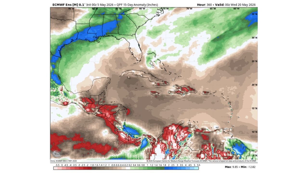
What the Next 15 Days Look Like
Two ensemble forecast maps valid through May 20, 2026 show the environment that will either support or suppress tropical development over the coming weeks.
Precipitation Anomaly (through May 20): The Gulf of Mexico, Cuba, Bahamas and most of the Caribbean are forecast to run significantly below normal on rainfall, shown in brown shading across the entire basin. Below-normal rainfall in the tropics means more sunshine, less cloud cover and continued ocean warming through mid-May. Florida and the Southeast show near to above-normal rainfall, while the deep tropics near Central America show some above-normal precipitation pockets.
Temperature Anomaly (May 10 through May 20): Surface temperatures across the Gulf of Mexico, Bahamas and Caribbean are forecast to run 1 to 7 degrees Celsius above normal through mid-May, shown in the orange and yellow shading dominating the entire basin. The warmest anomalies sit over the western Caribbean and Gulf, precisely the regions most relevant to any system that could affect Florida or the Gulf Coast.
Why Early Season Systems Near the Southeast Are Concerning
A pre-July tropical system affecting the southeastern United States would arrive before most residents have mentally shifted into hurricane preparedness mode. Early-season systems historically catch communities off guard because:
- Hurricane season awareness typically builds gradually through June and peaks in August and September
- Early systems often develop quickly over warm water with less atmospheric shear present before El Nino fully establishes its suppressing effects
- Florida’s Gulf Coast, the Bahamas and the Carolinas are the most statistically likely targets for any early-season system tracking northward from the warm Caribbean
The next 10 to 14 days of continued dry and sunny weather across the basin will be the critical window to watch. If ocean heat continues building unchecked through mid-May, the environment for early tropical development becomes increasingly favorable heading toward June.
WaldronNews.com will continue monitoring Caribbean ocean heat and early tropical development potential and will provide updated coverage as conditions evolve through May and into the start of hurricane season.