
Alabama Tornado Threat Upgraded to Enhanced Risk Wednesday as Birmingham, Tuscaloosa and Huntsville Enter 15 to 29 Percent EF2+ Tornado Zone From 5 PM to 1 AM
BIRMINGHAM, Alabama — Tornado probabilities across north and central Alabama have been formally upgraded for Wednesday, May 6, with the severe weather outlook now showing an Enhanced Risk Level 3 centered over Birmingham, Tuscaloosa, Huntsville and Gadsden and a 15 to 29 percent tornado probability with EF2 or stronger tornadoes specifically possible. The primary severe weather window runs from 5 PM Wednesday through 1 AM Thursday, meaning the most dangerous period extends well into the overnight hours when most residents will be asleep.
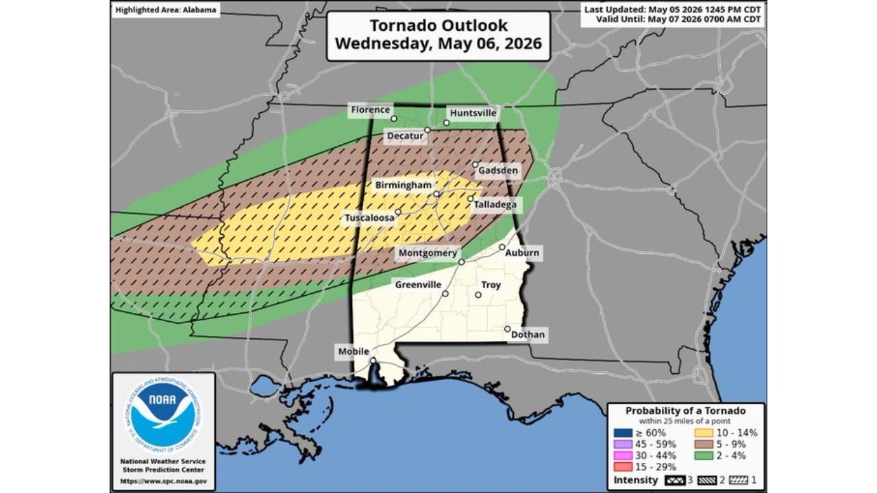
The Risk Zones
Enhanced Risk — Level 3 (Orange): The highest categorical risk covers the core of north and central Alabama, centered over Tuscaloosa and Birmingham and extending toward Decatur and Gadsden. This is a significant upgrade from earlier outlooks that had the area in a lower risk category.
Slight Risk — Level 2 (Yellow): Surrounds the Enhanced zone and covers a broader swath from Florence and Huntsville south through Montgomery, Auburn and Troy.
Marginal Risk — Level 1 (Green): Extends further outward toward Mobile and the state’s southern tier.
The Tornado Probability Breakdown
The tornado outlook map shows three distinct zones across Alabama:
15 to 29% — Hatched (EF2+ possible): Covers Tuscaloosa, Birmingham, Talladega and Montgomery. The hatching explicitly means EF2 or stronger tornadoes are anticipated within this zone. This is the highest tornado probability on the map and the area of greatest life-threatening risk Wednesday night.
10 to 14%: Extends north covering Decatur, Huntsville and Florence, where tornado potential is lower but still meaningful.
5 to 9%: Covers the outer portions of central Alabama including Gadsden and areas east of Birmingham.
The 5 PM to 1 AM Window
The eight-hour severe weather window is the most operationally important detail in this outlook. Storms are expected to begin firing across north Alabama around 5 PM, giving residents daylight hours to prepare and receive initial warnings. But the threat does not end at sunset.
The window extending to 1 AM Thursday means the highest-end tornado threat from mature supercells could arrive during the late evening hours across Birmingham, Tuscaloosa and Montgomery, when most people are home, off guard or asleep.
Anyone in the 15 to 29 percent hatched zone needs a working weather alert system that will wake them up if a tornado warning is issued overnight. A phone sitting on silent or a weather app with notifications disabled is not adequate preparation for a midnight tornado warning.
Cities That Must Prepare Before Wednesday Afternoon
- Tuscaloosa — inside the highest tornado probability zone and hatched for EF2+. This city’s history with violent tornadoes makes early preparation essential
- Birmingham — Enhanced Risk, 15 to 29 percent tornado zone, peak threat arriving during evening hours
- Huntsville and Decatur — 10 to 14 percent tornado probability, Enhanced Risk categorical zone
- Gadsden and Talladega — inside the hatched EF2+ zone
- Montgomery and Auburn — Slight Risk with tornado probability present through the overnight window
WaldronNews.com will continue tracking Wednesday’s Alabama tornado threat and will provide updated coverage as the 5 PM severe weather window opens Wednesday evening.