
2026 Atlantic Hurricane Season Forecast Calls for 9 to 13 Named Storms and 1 to 3 Major Hurricanes as Gulf of Mexico Faces Much Below Normal Activity
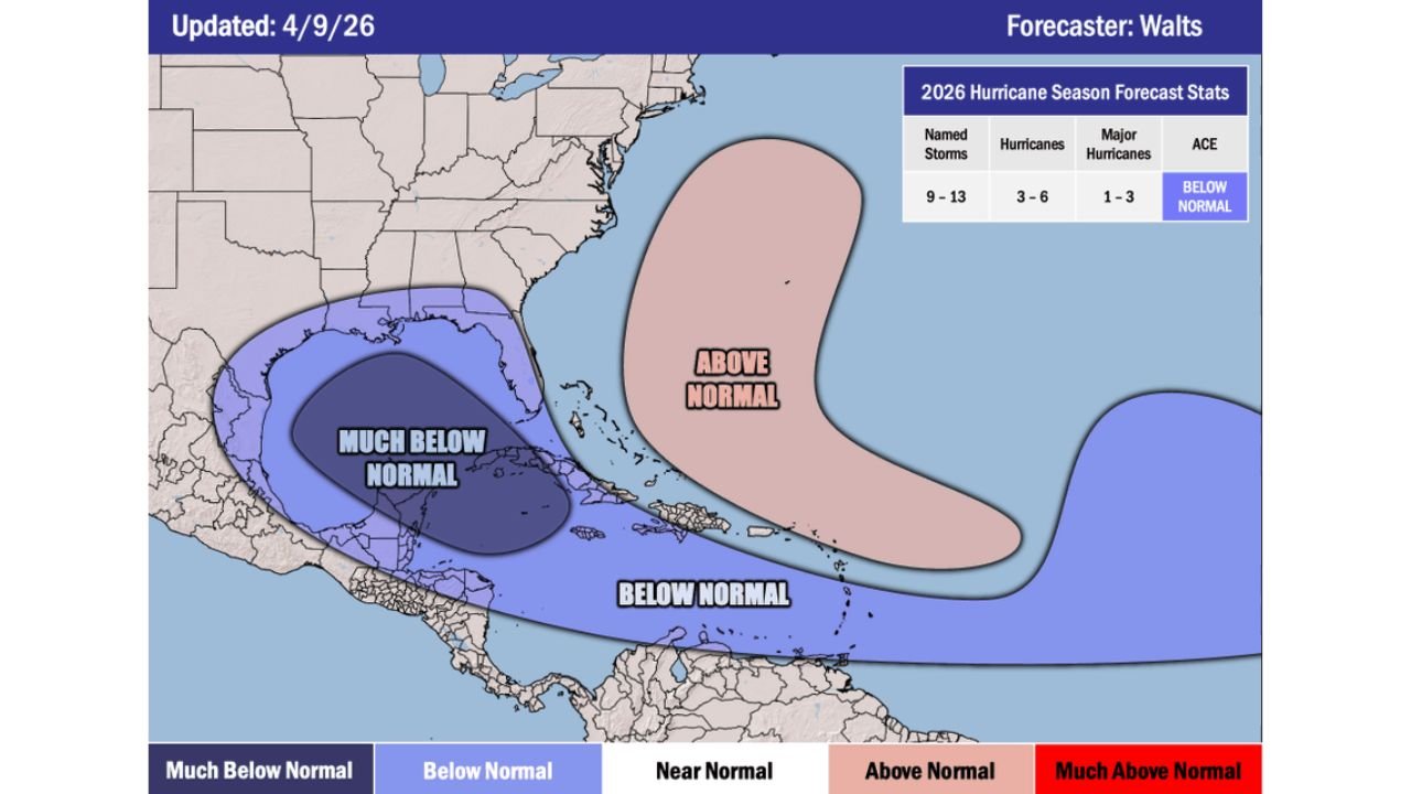
MIAMI, Florida — The 2026 Atlantic hurricane season is forecast to produce 9 to 13 named storms, 3 to 6 hurricanes and 1 to 3 major hurricanes, according to an outlook updated April 9, 2026. Overall seasonal energy is expected to run below normal, with the Gulf of Mexico facing a much below normal activity zone while the open Atlantic carries an above normal storm development corridor. The forecast reflects the growing influence of El Nino, which historically suppresses Gulf and Caribbean activity while allowing the central and eastern Atlantic to remain more active.
The Numbers at a Glance
| Category | Forecast |
|---|---|
| Named Storms | 9 to 13 |
| Hurricanes | 3 to 6 |
| Major Hurricanes (Category 3+) | 1 to 3 |
| Accumulated Cyclone Energy | Below Normal |
A normal Atlantic hurricane season produces approximately 14 named storms, 7 hurricanes and 3 major hurricanes. This outlook sits below those thresholds across all categories.
Where the Activity Will and Won’t Be
The activity map divides the Atlantic basin into three distinct zones:
Much Below Normal — Gulf of Mexico and Caribbean: The deepest suppression sits over the Gulf of Mexico and western Caribbean, shown in dark purple. This is the most directly impactful zone for Texas, Louisiana, Mississippi, Alabama and Florida’s Gulf Coast, as reduced activity here means fewer direct Gulf landfalling threats compared to recent active seasons. El Nino’s wind shear effects are strongest in this region.
Below Normal — Tropical Atlantic and Caribbean: A broader below-normal zone extends across the Caribbean Sea and southern tropical Atlantic, indicating generally suppressed development across the basin’s most historically active corridors.
Above Normal — Central and Open Atlantic: A pink above-normal zone sits over the central open Atlantic, roughly between the Lesser Antilles and the mid-Atlantic ridge. This is where the season’s most active development is expected. Storms forming in this zone can still threaten the East Coast and Florida if they track westward, but the open Atlantic corridor is further from the Gulf Coast than the most dangerous development zones.
What This Means for the United States Coast
The much below normal designation for the Gulf of Mexico is the most practically important detail for millions of residents across Texas, Louisiana, Mississippi, Alabama and the Florida Panhandle. Fewer Gulf storms means fewer direct landfalling threats to those coastlines compared to seasons driven by La Nina or neutral ENSO conditions.
However, 1 to 3 major hurricanes still represents a meaningful threat. A single Category 3, 4 or 5 storm making landfall anywhere along the Gulf or Atlantic Coast would have catastrophic local impacts regardless of overall seasonal totals. Below normal seasons still produce dangerous storms.
Florida’s Atlantic Coast and the Carolinas face more exposure than the Gulf Coast this season given the above-normal activity zone sitting in the open Atlantic where westward-tracking storms could approach the East Coast corridor.
WaldronNews.com will continue tracking 2026 Atlantic hurricane season development and will provide updated coverage as the season approaches its June 1 official start.