
Texas, Oklahoma and Arkansas Face Imminent Severe Weather Watch as 2 to 3.5 Inch Hail, 65 to 80 mph Winds and Tornadoes Up to 125 mph Threaten Northeast Texas and Southwest Arkansas Tuesday Evening
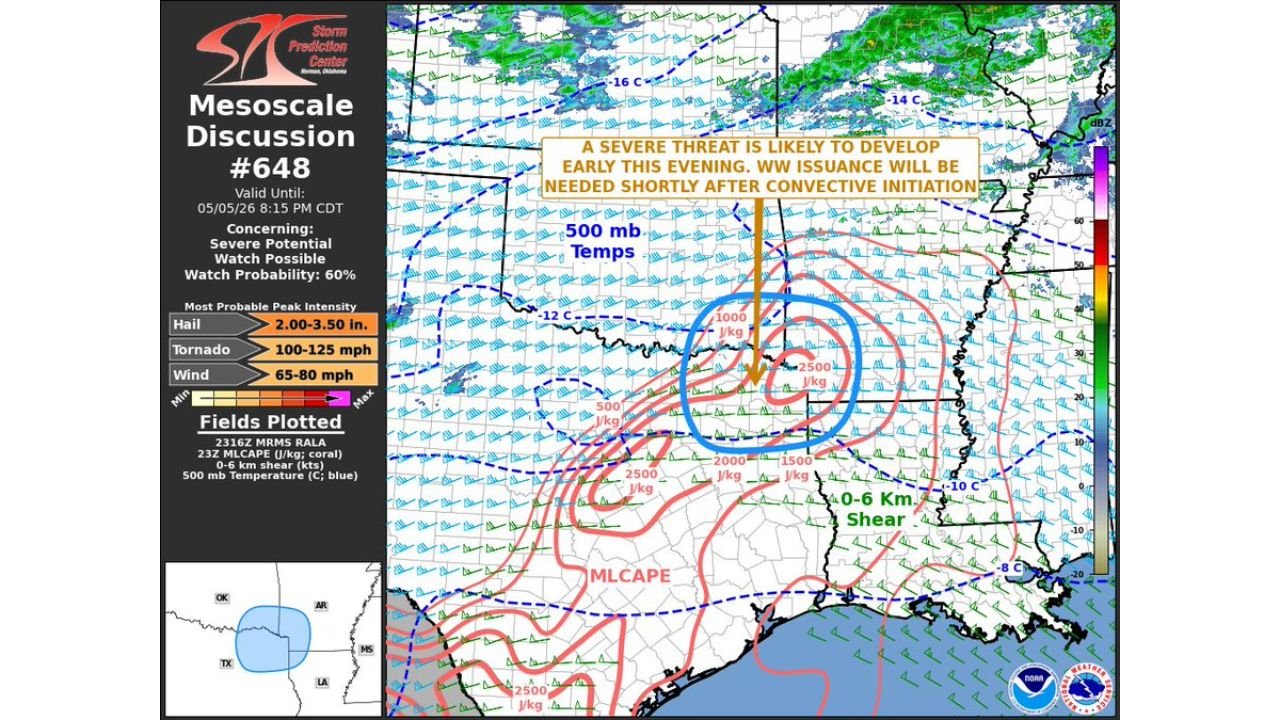
TEXARKANA, Texas — A formal Mesoscale Discussion has been issued with a 60 percent watch probability for northeast Texas, far southeast Oklahoma and southwest Arkansas, signaling that a Severe Thunderstorm or Tornado Watch is likely to be issued shortly after storms initiate early this Tuesday evening, May 5. The discussion, valid until 8:15 PM CDT, identifies peak hazard values that place this squarely in dangerous territory for communities near Texarkana, Tyler and the Arkansas-Texas border.
What the Mesoscale Discussion Says Is Coming
Three specific peak intensity values are formally listed:
- Hail: 2.00 to 3.50 inches — baseball-sized hail capable of destroying vehicles, shattering windows and causing severe roof damage
- Tornado winds: 100 to 125 mph — EF2 range at the low end, pushing toward EF3 at the upper end
- Straight-line wind gusts: 65 to 80 mph — strong enough to snap trees, down power lines and cause structural damage across a wide area
A watch issuance is considered likely shortly after convective initiation, meaning once storms begin firing this evening, a watch covering this area is expected to follow quickly.
What the Atmospheric Data Shows
The mesoscale discussion map plots three critical atmospheric fields simultaneously over the northeast Texas and southwest Arkansas corridor:
MLCAPE reaching 2,000 to 2,500 J/kg across the target zone, with the highest instability values concentrated in the blue-circled area directly over the Texas-Arkansas border region. Mixed-Layer CAPE at these values provides explosive energy for violent thunderstorm updrafts.
0 to 6 km bulk shear is plotted across the region, providing the deep-layer wind shear that organizes supercells and sustains them over long distances. The combination of 2,000+ J/kg CAPE and strong deep-layer shear in the same location is the core reason this discussion was issued.
500 mb temperatures showing the cold air aloft at -12 to -16 degrees Celsius over the warm sector below, increasing the atmospheric lapse rates that allow storm updrafts to accelerate rapidly and produce large hail.
Cities in the Watch Probability Zone
The small map inset shows the watch probability area covering the intersection of Oklahoma, Arkansas, Texas and Louisiana. Communities most directly at risk as storms initiate this evening:
- Texarkana, Texas and Arkansas — directly inside the target zone
- Tyler and Longview, Texas — within the northeast Texas risk corridor
- Idabel and Hugo, Oklahoma — southeast Oklahoma communities in the watch area
- Southwest Arkansas communities near Arkadelphia, Camden and Magnolia
Act Before Storms Initiate
The critical phrase in this discussion is shortly after convective initiation. That means the watch has not been issued yet but will be once storms begin. By the time a watch appears on phones across northeast Texas and southwest Arkansas, storms will already be developing. Residents in this zone should not wait for the watch to begin preparing.
WaldronNews.com will continue tracking this imminent severe weather threat across Texas, Oklahoma and Arkansas and will provide updates as watch issuance and storm development occur Tuesday evening.