
Gulf Coast and Atlantic Face Early Season Tropical Development Possible by June as Long Range Models Show Storm System Forming While Plains Pattern Shifts Dramatically by Late May
NEW ORLEANS, Louisiana — Long-range weather models are hinting at early season tropical development most likely in June 2026, with a potential system showing up in the western Atlantic and Gulf of Mexico corridor in extended model guidance. At the same time, a dramatic pattern shift is forecast across the central United States by late May into early June that would bring a significant cooldown to the Plains while setting the stage for an active severe weather and tropical transition period.
What the Tropical Models Are Showing
The tropical development areas highlighted in pink on the extended tropical outlook show potential areas of interest across:
- Western Caribbean and Gulf of Mexico — the most favored zone for early season development based on current guidance
- Central Atlantic — a secondary area of interest further east
- Western Atlantic near the Bahamas corridor — a third zone being watched
This is explicitly described as early-season model speculation — the MJO atmospheric wave pattern and European model packages have not yet confirmed the signal, meaning these are hints rather than reliable forecasts. June development further west in the Gulf is considered the most likely scenario if early season activity does materialize.
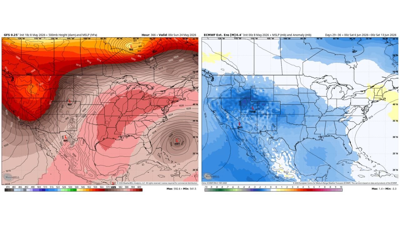
What the GFS Shows for Late May
The GFS model valid Sunday May 24, 2026 shows:
- A deep low pressure system at 996 mb developing over the southern Plains and northern Mexico corridor
- Above normal heights and warmth dominating the western United States with values running well above the 580 dam threshold across the Southwest
- A second low pressure center pulling into the northern Plains near 969 mb
- The eastern United States running warmer than normal at the surface with above-normal heights building in from the west
- A 1001 mb closed low developing off the Southeast coast in the western Atlantic — this is the feature being flagged as a potential early tropical development area
What the Euro Extended Ensemble Shows for June 6 Through June 13
The European extended ensemble mean sea level pressure anomaly valid June 6 through June 13, 2026 shows a dramatic pattern:
- A massive below-normal pressure anomaly of 3 to 8 mb covering the entire western United States from California through the Rockies and into the northern Plains — indicating a deep and persistent trough digging into the West
- The anomaly is centered over Nevada, Utah and Colorado with the deepest values running 6 to 8 mb below normal
- The eastern United States turns near to slightly above normal — a pattern that would shift the severe weather focus westward compared to the current active eastern pattern
- New England shows slightly above normal pressure — drier and more settled conditions for the Northeast in this timeframe
What This Pattern Means Going Forward
The late May and early June pattern evolution suggests:
- The active severe weather pattern currently focused on the Plains and Midwest will interact with the deep western trough developing through late May — potentially producing significant outbreak days as the trough ejects eastward
- Early tropical development in June remains possible but is not yet confirmed by the most reliable long-range guidance — the Gulf and western Caribbean are the areas to watch
- The dramatic pressure pattern shift seen in the Euro extended ensemble for June 6 through June 13 would represent a major restructuring of the entire United States weather pattern away from the current setup
What to Watch Through June
- Gulf Coast residents from Texas through Florida should begin monitoring tropical weather outlooks as June approaches — early season development, while less common, can catch communities off guard
- The western Atlantic low showing up in the GFS for late May is the feature most worth watching for potential tropical organization as it moves into warmer waters
- Late May severe weather across the Plains remains the more immediate and higher-confidence threat — the tropical signal is speculative at this range
- The June 6 through June 13 western trough in the Euro ensemble would set up a classic late spring severe weather pattern if it verifies — watch for model agreement to increase as the timeframe approaches
WaldronNews.com will continue monitoring early season tropical development and the late May pattern shift across the Gulf Coast and Plains and will provide updates as models gain confidence in the June outlook.