
Central and Eastern United States Face Clear Signal for Severe Weather Uptick Starting May 16 Through Late May as Pattern Shifts With Moist Flow and Troughing Returns
KANSAS CITY, Missouri — A clear signal for a significant uptick in severe weather is emerging for mid to late May 2026 across the central and eastern United States. Ensemble model data shows the severe weather environment dropping to its quietest point of the current period around May 13 through May 15 before a sharp pattern shift brings moist flow and troughing back into the eastern United States by mid-month. The signal after May 16 is unmistakable — and multiple model runs are agreeing on the timing.
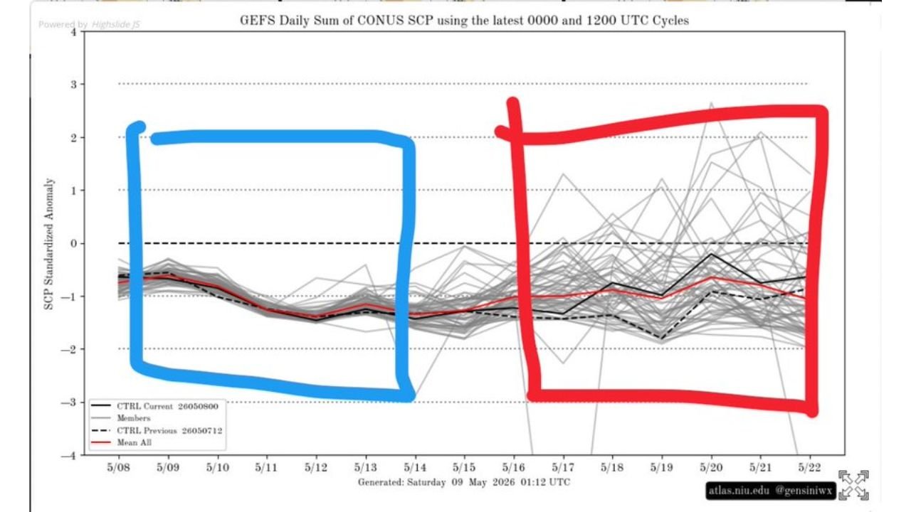
What the Ensemble Data Shows
The GEFS daily sum of severe weather potential across the continental United States generated Saturday May 9, 2026 shows two distinct phases highlighted on the chart:
Blue Box — Current Quiet Period May 8 through May 14:
- The ensemble mean shown in red is running at -1 to -2 standardized anomaly — well below normal severe weather activity
- Nearly all individual ensemble members are clustered below the zero line
- This confirms the current pattern is suppressed for severe weather through approximately May 14
- Texas Sunday May 10 is an exception within this quiet period as a localized Enhanced Risk event
Red Box — Active Period Beginning May 16 through May 22:
- The ensemble mean begins climbing sharply back toward and above zero starting around May 16
- Individual members spread dramatically — some reaching as high as 2.0 to 2.5 standardized anomaly which represents well above normal severe weather activity
- The mean stabilizes near -0.5 to 0 through May 17 to 20 before individual members push significantly higher
- The spread increasing in the red box is a sign that while timing is not pinpointed, the pattern shift toward active severe weather has high confidence
What Is Driving the Pattern Shift
- Moist flow returning to the eastern United States by mid-month — Gulf moisture surging northward provides the instability fuel needed for severe thunderstorm and tornado development
- Troughing developing in the eastern United States — upper-level disturbances digging into the East provide the wind shear and lift that organizes storms into supercells and squall lines
- The combination of increased moisture plus upper-level support arriving simultaneously after May 16 is the classic severe weather recipe that has driven the most active outbreak days of the 2026 spring season so far
Who Should Be Watching After May 16
Based on the pattern description of moist flow and eastern troughing:
- Missouri, Illinois, Indiana and Ohio sit in the primary zone where eastern troughing and Gulf moisture typically clash — these states face the highest probability of organized severe weather after May 16
- Tennessee, Kentucky and the mid-South fall within the moist flow corridor and face elevated risk through the late May window
- Kansas and Oklahoma remain in play as the moisture source region — watch for the southern Plains to stay active as the pattern shift progresses
- The entire corridor from the Plains through the Ohio Valley should treat the May 16 through May 22 window as an elevated severe weather period
What to Watch This Week
- May 10 through May 14 stays relatively quiet for most of the country outside of Sunday’s Texas event — use this window to prepare
- May 15 to 16 is the transition date — watch for the pattern shift to begin showing up in shorter-range model guidance as that window approaches
- Exact outbreak days and target areas will come into focus within 3 to 5 days of each event — daily forecast monitoring starting May 13 is recommended
- The spread in ensemble members means some solutions produce near-normal activity while others produce major outbreak days — the uncertainty argues for staying alert rather than assuming the quiet pattern continues
WaldronNews.com will continue tracking the mid to late May severe weather signal and will provide updates as the pattern shift comes into focus and specific threat days become clearer through the coming week.