
Washington DC Faces 80s and Possible 90 Degree Highs Saturday May 16 Through Wednesday May 21 With Record Highs of 92 and 96 Degrees Within Reach
WASHINGTON, DC — A solid stretch of spring heat is on track for the Washington DC region beginning Saturday, May 16, 2026, with highs each day from Saturday through Wednesday, May 20 expected to reach at least the 80s and possibly climbing to 90 degrees or higher starting Sunday, May 17.
Washington’s record highs of 92 degrees for Sunday and 96 degrees for Monday through Wednesday could come close to being challenged on a couple of days during this heat stretch.
Day by Day Heat Outlook
The warming trend builds quickly starting Saturday and holds through mid-week before cooling returns:
- Saturday, May 16 kicks off the heat stretch with highs reaching at least the 80s across the Washington DC region, marking a dramatic warm-up from the cool and showery conditions earlier this week.
- Sunday, May 17 begins the window where temperatures could reach 90 degrees or higher across Washington DC, and the record high of 92 degrees for this date could potentially be challenged depending on how quickly the heat builds.
- Monday, May 18 through Wednesday, May 20 represent the peak of the heat stretch, with highs staying in the 80s at minimum and 90 degree readings possible on one or more days. The record high of 96 degrees for this multi-day period is unlikely to be reached but forecasters note the region could come close on a couple of the days.
- Late next week, temperatures should cool off closer to average, which for this time of year means highs in the upper 70s across the Washington DC area.
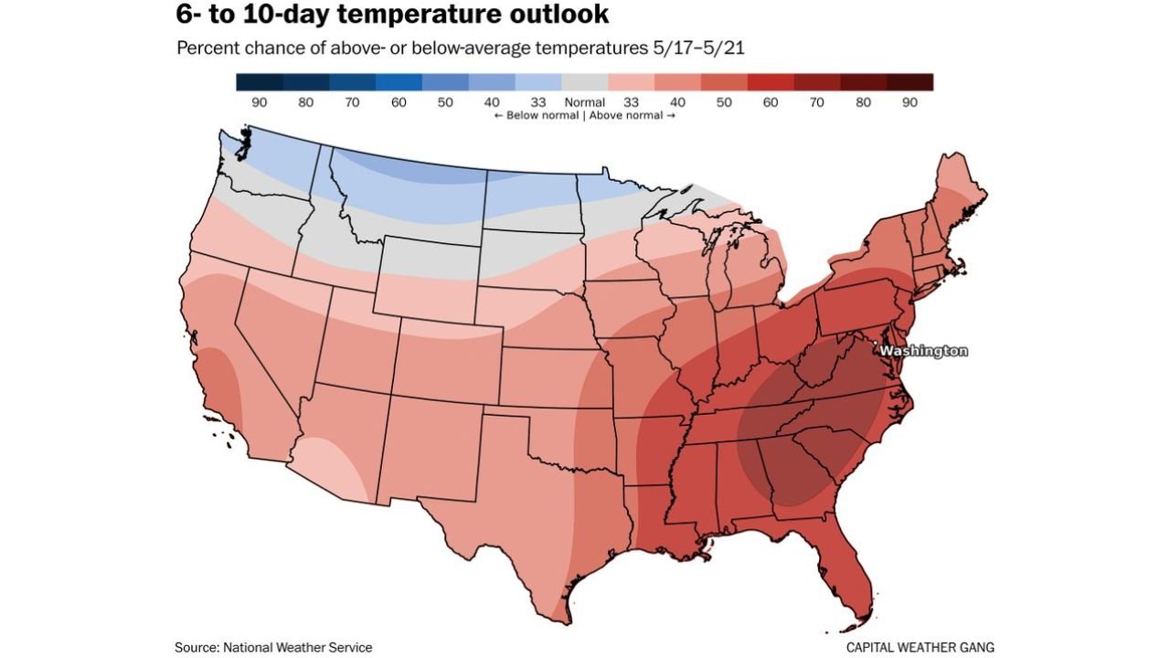
What the 6 to 10 Day Temperature Outlook Shows
The 6 to 10 day temperature outlook valid Sunday, May 17 through Thursday, May 21 confirms the above-normal heat pattern across a large portion of the country:
- Washington DC and the broader East Coast fall within the deepest red zone on the outlook map, indicating a 70 to 90 percent chance of above-normal temperatures during the May 17 through May 21 period.
- The above-normal temperature signal extends across a massive swath of the East Coast and Southeast, with Washington DC sitting near the core of the highest-confidence warm zone on the entire map.
- The Northwest is the only region showing below-normal temperature chances during this same period, as a ridge of high pressure builds across the East and pushes cooler air into the far Northwest.
How Close Could DC Get to Records
Washington’s record highs for this period are notable benchmarks that forecasters are watching:
- The record high for Sunday, May 17 in Washington DC stands at 92 degrees, a temperature that would be possible if the heat builds more aggressively than currently expected during the opening days of this warm stretch.
- The record high for Monday, May 18 through Wednesday, May 20 in Washington DC stands at 96 degrees, an extreme reading that is unlikely to be reached but could be approached on one or more days if the hottest scenarios verify.
- Even without breaking records, multiple days in the upper 80s to low 90s across Washington DC during the May 16 through May 20 period will feel significantly warmer than typical mid-May conditions, especially coming directly after a cool and wet stretch.
Heat Safety for Next Week
Residents across the Washington DC region should prepare now for this extended above-normal heat stretch:
- Stay hydrated consistently throughout each day from Saturday, May 16 through Wednesday, May 20, particularly if you plan to be outdoors during peak afternoon heating hours between noon and 6:00 PM.
- Check on elderly neighbors, young children and pets daily throughout this heat stretch as these groups face the highest risk of heat-related illness during multi-day above-normal temperature events.
- Temperatures should return closer to the upper 70s by late next week, providing relief after what could be a 5 to 6 day run of 80s and 90s across the Washington DC region.
WaldronNews.com will continue tracking this spring heat stretch across Washington DC and will provide updates as daily high temperatures, record high potential and the cooling timeline through Wednesday, May 20 develop.