
Oklahoma, Kansas, Iowa, Illinois and Missouri Face Scattered Supercells With 2 Inch Plus Hail, 60 mph Gusts and Tornadoes From Oklahoma City Through Kansas City and Des Moines Saturday May 16 Through Sunday May 17
KANSAS CITY, Kansas — Saturday, May 16 and Sunday, May 17, 2026 will feature a significant severe weather threat across the Plains, Corn Belt and parts of the Midwest, marking the beginning of a severe weather uptick after a quiet start to what is typically peak tornado season.
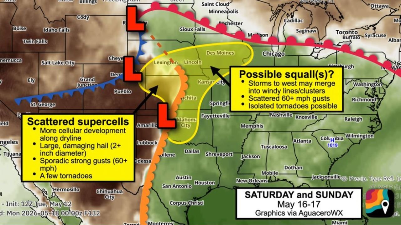
Scattered supercells capable of 2 inch plus diameter hail, sporadic 60 mph wind gusts and a few tornadoes are expected Saturday, with storms potentially merging into squall lines producing scattered 60 mph gusts and isolated tornadoes across eastern portions of the risk area Sunday.
What Is Driving This Weekend Setup
A low pressure system ejecting eastward out of the Rockies is the primary engine behind this weekend’s severe weather threat:
- The low pressure system will sharpen a dryline, which is a boundary where dry air from the west collides with moisture-rich air flowing northward from the Gulf of Mexico to the east. This collision zone is one of the most potent ingredients for severe thunderstorm development anywhere in the world.
- Dry air meeting Gulf moisture along this dryline will help brew initial scattered supercell storms across the Plains on Saturday, May 16, with storm development most likely along the dryline boundary from Oklahoma City northward through Wichita and Kansas City.
- The system then pushes eastward into the Corn Belt and Midwest by Sunday, May 17, increasing the squall line and damaging wind threat for communities from Kansas City eastward through Des Moines and Chicago.
Saturday Scattered Supercell Threat
The primary Saturday severe weather threat comes from scattered supercells developing along the dryline:
- Large, damaging hail reaching 2 inch plus diameter is one of the most significant threats with Saturday’s supercells. Hail this size is roughly the diameter of a baseball and can destroy vehicle roofs, break windows and cause catastrophic damage to crops and outdoor property within minutes.
- Sporadic strong gusts of 60 mph or more are possible with any supercell that develops along the dryline from Oklahoma City through Wichita and Kansas City on Saturday.
- A few tornadoes are anticipated with the scattered supercell threat Saturday, as rotating storms developing along a sharp dryline in mid-May across the Plains are capable of producing significant tornadoes under the right conditions.
- Amarillo, Texas, Lubbock, Texas, Oklahoma City, Oklahoma, Wichita, Kansas and Kansas City all sit within or near the primary supercell development zone for Saturday, May 16.
Sunday Squall Line and Wind Threat
As storms merge and push eastward Sunday, the threat character shifts:
- Storms developing along the dryline Saturday are expected to eventually grow into one or more windy lines or clusters, particularly across eastern portions of the risk area on Sunday, May 17.
- Any squall lines that develop will pose a primary concern for straight-line wind gusts of 60 mph or more across a broad area from Kansas City through Des Moines, Chicago and surrounding Midwest communities.
- Isolated tornadoes remain possible even with squall line activity on Sunday, as embedded rotation within fast-moving line segments can produce brief but dangerous spin-up tornadoes with little warning.
- Des Moines, Iowa, Chicago, Illinois and Springfield, Missouri all fall within the potential squall line impact zone on Sunday, May 17.
What 2 Inch Plus Hail Means
Hail larger than 2 inches in diameter is classified as very large to giant hail and causes a significantly different level of damage compared to smaller hail:
- At 2 inch diameter, hail falls fast enough to shatter vehicle windows, punch through windshields and leave deep dents in metal roofing and siding across affected communities from Oklahoma City through Wichita and Kansas City.
- Crops across the Plains and Corn Belt are highly vulnerable to 2 inch plus hail during May, when many fields are in early growth stages and a single hail event can wipe out an entire season’s planting across a large area.
- Move all vehicles into covered shelter before storm development begins Saturday afternoon if you are in or near Oklahoma City, Wichita, Amarillo or Lubbock.
Preparation Steps Before Saturday
Residents across the Plains, Corn Belt and Midwest have time to prepare before this weekend system arrives:
- Enable severe thunderstorm and tornado alert notifications on your phone now so any watches or warnings issued Saturday, May 16 or Sunday, May 17 reach you immediately.
- Have a shelter plan ready at home, at work and for any outdoor activities planned for this weekend across Oklahoma City, Wichita, Kansas City, Des Moines and Chicago.
- Monitor daily forecast updates through Friday, May 15 as storm timing, the dryline position and exact threat details will sharpen considerably in the final 24 to 48 hours before the event.
WaldronNews.com will continue tracking this weekend severe weather threat across the Plains, Corn Belt and Midwest including Oklahoma City, Wichita, Kansas City, Des Moines and Chicago and will provide updates as supercell, hail, wind and tornado details develop ahead of Saturday, May 16 through Sunday, May 17.