
Wisconsin, Minnesota, Iowa, Illinois, Indiana and Missouri Face 150 to 235 Percent of Normal Rainfall May 16 Through May 23 With Madison, Green Bay, Minneapolis and Des Moines Seeing Heaviest Totals
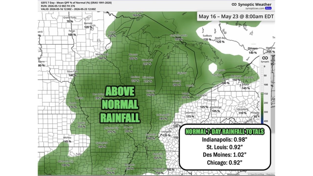
DES MOINES, Iowa — An active pattern returning late this weekend will deliver well above normal rainfall across a large portion of the Midwest from Saturday, May 16 through Saturday, May 23, 2026, with multiple cities forecast to receive 150 to 235 percent of their normal 7-day rainfall totals during this period.
Typical rainfall for this May 16 through May 23 period runs 0.9 to 1.0 inches across the region, meaning many cities could see nearly double or more than double their normal amounts before the active pattern ends.
City by City Rainfall Percentage Forecast
The percent of normal rainfall forecast valid May 16 through May 23 shows dramatically above normal totals across the Midwest:
- Madison, Wisconsin is forecast at 235 percent of normal rainfall, the highest reading visible on the map, meaning the city could receive more than double its typical 7-day total during this period.
- Green Bay, Wisconsin is forecast at 215 percent of normal, placing it among the wettest cities in the entire outlook zone for May 16 through May 23.
- Milwaukee, Wisconsin is also forecast at 215 percent of normal, matching Green Bay for one of the highest above-normal rainfall signals in the region.
- Wausau, Wisconsin comes in at 205 percent of normal, continuing the pattern of extreme above-normal rainfall signals concentrated across Wisconsin during this period.
- Minneapolis, Minnesota is forecast at 160 percent of normal, with Duluth, Minnesota tracking at 155 percent of normal through May 23.
- Des Moines, Iowa is forecast at 195 percent of normal against a typical 7-day total of 1.02 inches, meaning Des Moines could pick up roughly 2 inches of rainfall during this active stretch.
- Chicago, Illinois is forecast at 195 percent of normal against a typical 7-day total of 0.92 inches, putting the city on track for nearly double its normal rainfall through May 23.
- Indianapolis, Indiana is forecast at 185 percent of normal against a typical 7-day total of 0.98 inches, meaning Indianapolis could see close to 1.8 inches during the May 16 through May 23 period.
- St. Louis, Missouri is forecast at 195 percent of normal against a typical 7-day total of 0.92 inches, tracking toward nearly double normal rainfall through May 23.
- Jefferson City, Missouri is forecast at 175 percent of normal with Springfield, Missouri also at 195 percent through May 23.
- Lansing, Michigan comes in at 200 percent of normal with Detroit, Michigan at 185 percent and Saginaw, Michigan at 200 percent of normal through May 23.
- Omaha, Nebraska is forecast at 170 percent of normal and Sioux Falls, South Dakota at 140 percent through May 23.
- Topeka, Kansas is forecast at 155 percent and Wichita, Kansas at 145 percent of normal through May 23.
- Oklahoma City, Oklahoma is tracking at 180 percent of normal through May 23, one of the higher readings in the southern portion of the above-normal zone.
- Little Rock, Arkansas and Memphis, Tennessee are both forecast at 175 percent and 195 percent of normal respectively through May 23.
What Above Normal Rainfall Means for the Region
Rainfall totals running 150 to 235 percent of normal over a 7-day period represent a significant water input across the Midwest:
- Cities like Madison and Green Bay at 215 to 235 percent of normal could see localized flooding in low-lying areas, poor drainage zones and near streams and rivers that are already running at or above normal levels heading into this active stretch.
- The combination of multiple rounds of heavy rainfall over 7 days increases the risk of flash flooding across Wisconsin, Minnesota, Iowa, Illinois, Indiana and Missouri, particularly in urban areas where pavement prevents water from soaking into the ground quickly.
- Farmers across Iowa, Illinois and Indiana with fields in early planting stages should monitor soil saturation levels closely as 185 to 195 percent of normal rainfall can create waterlogged conditions that delay fieldwork and stress young crops.
Timing and What Comes Next
The active pattern begins Saturday, May 16 and runs through Saturday, May 23, delivering multiple rounds of rainfall across the Midwest rather than one single heavy rain event:
- Multiple storm systems are expected to track through the region during this 7-day window, with each system adding to the cumulative above-normal rainfall totals shown on the forecast map.
- Residents across Madison, Green Bay, Milwaukee, Minneapolis, Des Moines, Chicago, Indianapolis and St. Louis should be prepared for repeated rounds of rain and potentially thunderstorms through May 23.
- Areas currently dry across the Midwest will see significant relief from this active pattern, though the heaviest totals concentrated across Wisconsin will need to be monitored carefully for flooding potential.
WaldronNews.com will continue tracking above normal rainfall totals across Wisconsin, Minnesota, Iowa, Illinois, Indiana and Missouri including Madison, Green Bay, Des Moines, Chicago, Indianapolis and St. Louis and will provide updates as storm timing and rainfall accumulations develop through Saturday, May 23.