
Montana, Idaho, Wyoming and Nevada Face Critical Fire Weather and Severe Wind Gusts Wednesday May 13 While Rain and Thunderstorms Spread Across the Northeast and Southeast
BILLINGS, Montana — Scattered severe thunderstorms are possible across portions of the northern High Plains this Wednesday, May 13, 2026 afternoon and evening, with severe wind gusts as the primary hazard. Critical fire weather conditions are developing simultaneously across parts of the northern Great Plains and Great Basin as gusty winds and low relative humidity combine across Montana, Idaho, Wyoming and Nevada.
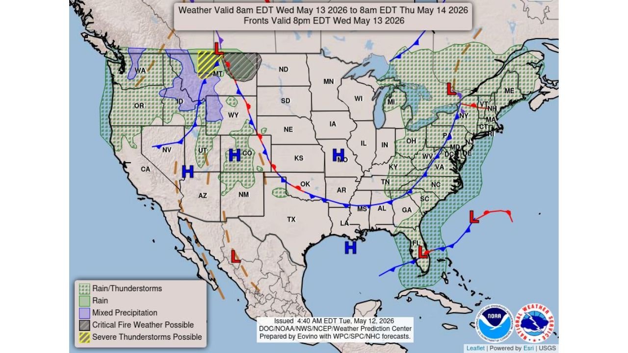
The weather outlook is valid from 8:00 AM EDT Wednesday, May 13 through 8:00 AM EDT Thursday, May 14, issued at 4:40 AM EDT Tuesday, May 12.
Severe Thunderstorm and Fire Weather Zone
Two separate but simultaneous hazards are in place across the northern High Plains and Great Basin on Wednesday, May 13:
- Severe thunderstorms are possible across portions of Montana and Wyoming, shown in the yellow hatched zone on the map, where severe wind gusts are the primary concern during Wednesday afternoon and evening hours.
- Critical fire weather conditions are possible across parts of Montana, Idaho, Wyoming and Nevada, shown in the gray hatched zone, where gusty winds combined with low relative humidity create dangerous conditions for rapid fire spread.
- The combination of severe thunderstorm wind gusts and critical fire weather in overlapping zones across Montana and Wyoming makes Wednesday a particularly dangerous day across the northern High Plains for both storm damage and wildfire risk.
Critical Fire Weather Explained
Critical fire weather conditions develop when two key ingredients come together at the same time:
- Gusty winds increase the rate at which any fire spreads across the landscape and make it extremely difficult for firefighters to control or contain active blazes across Montana, Idaho, Wyoming and Nevada.
- Low relative humidity dries out vegetation rapidly, turning grasses, shrubs and trees into highly combustible fuel that can ignite from a single spark and spread within minutes under windy conditions.
- Any outdoor burning, equipment use that produces sparks or open flames near vegetation should be avoided entirely across Montana, Idaho, Wyoming and Nevada on Wednesday, May 13 given the critical fire weather outlook.
Mixed Precipitation Across Montana and Idaho
In addition to severe thunderstorms and fire weather, a mixed precipitation zone is shown across portions of Montana and Idaho in the purple shaded area on the Wednesday weather map:
- Mixed precipitation including rain, snow or sleet is possible across higher elevations of Montana and Idaho on Wednesday, May 13 as cold air associated with the low pressure system dropping southward interacts with moisture moving into the region.
- Residents in mountainous areas of Montana and Idaho should be prepared for slippery road conditions and reduced visibility in addition to the fire weather and severe storm threats affecting lower elevations.
Rain and Thunderstorms Across the Northeast and Southeast
A broad rain and thunderstorm zone covers large portions of the Northeast and Southeast on Wednesday, May 13:
- Rain and thunderstorms are shown across a large swath of the Northeast including New York, Pennsylvania, Vermont, New Hampshire, Massachusetts, Connecticut and Rhode Island during the Wednesday valid period.
- The Southeast and Gulf Coast states including Florida, Georgia, Alabama, Mississippi and Louisiana also fall within the rain and thunderstorm zone valid through 8:00 AM EDT Thursday, May 14.
- A cold front shown on the map tracking from the Great Lakes southwestward through Oklahoma and into New Mexico will be the primary focus for rain and storm activity across the central and eastern United States through Wednesday and into Thursday.
Safety Reminders for Wednesday
Residents across all affected states should take region-specific precautions for Wednesday, May 13:
- If you are in Montana, Idaho, Wyoming or Nevada under the critical fire weather zone, do not start any outdoor fires under any circumstances and report any smoke you see immediately to local fire authorities.
- If you are in Montana or Wyoming under the severe thunderstorm possible zone, keep weather alerts active through Wednesday afternoon and evening and be prepared to take shelter quickly if a severe thunderstorm warning is issued for your area.
- If you are in the Northeast or Southeast rain and thunderstorm zone, carry an umbrella and allow extra travel time Wednesday as wet roads and reduced visibility will affect commutes throughout the day.
WaldronNews.com will continue tracking critical fire weather, severe thunderstorm wind gusts and the rain and thunderstorm zones across Montana, Idaho, Wyoming, Nevada and the Northeast and Southeast and will provide updates as conditions develop through Thursday, May 14.