
Florida Faces Multiple Rotating Storms Moving Toward Orlando and Space Coast With Hail, Wind and Brief Tornado Possible as Severe Risk Higher Near Orlando Than Tampa Tuesday May 12 at 3:00 PM
ORLANDO, Florida — Multiple strong storms showing broad rotation were tracked across western central Florida as of 3:00 PM Tuesday, May 12, 2026, all moving east toward Orlando and the Space Coast in the coming hours. If any of these storms turn severe they could produce hail, wind and a brief tornado, with the severe risk considered higher near Orlando than in the Tampa area where the storms are currently located.
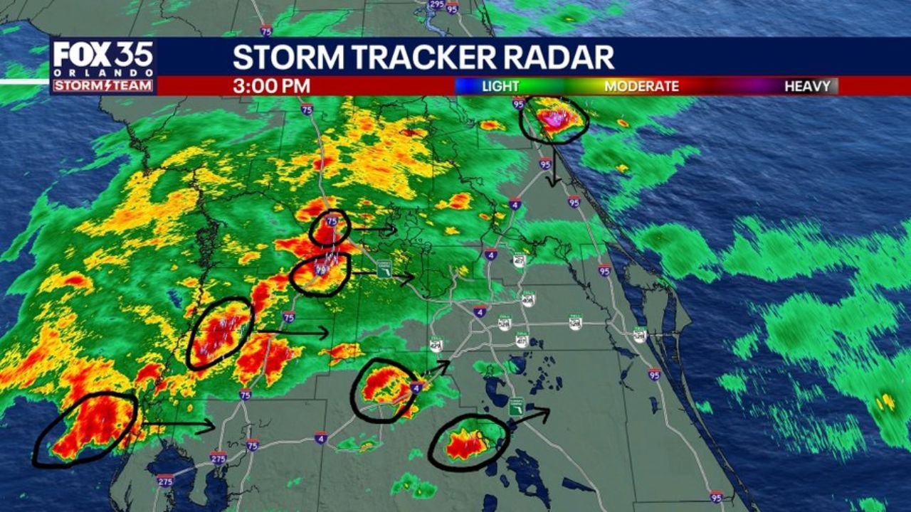
An unusual storm near Palm Coast is additionally moving south toward Daytona rather than the typical eastward direction, adding an extra layer of complexity to this afternoon’s threat.
What Radar Is Showing at 3:00 PM
Storm Tracker Radar at 3:00 PM shows several circled storm cells across western central Florida with multiple areas of concerning rotation:
- Multiple storm cells are circled on the 3:00 PM radar between the Tampa area and Orlando, all tracking eastward along the Interstate 4 corridor toward Orlando and the Space Coast.
- The storm wind radar at 3:00 PM shows several circled areas of broad rotation within these cells, meaning winds inside the storms are beginning to rotate in a pattern that can eventually produce a tornado if the rotation tightens.
- A separate storm cell is visible near Palm Coast on the 3:00 PM radar moving southward toward Daytona rather than east, which forecasters are describing as an unusual and odd ball storm track worth monitoring closely this afternoon.
- The broader radar view at 3:00 PM shows the entire storm complex stretching across western central Florida with the heaviest cells shown in red and yellow pushing steadily eastward toward Orlando.
Why Orlando Faces Higher Severe Risk Than Tampa
The severe weather risk is expected to increase as these storms move east toward Orlando and away from Tampa:
- Wind shear, which is a change in wind speed or direction at different heights in the atmosphere that can cause storms to rotate more intensely, is expected to increase as the storms move eastward from the Tampa area toward Orlando.
- When wind shear increases around an already rotating storm, that storm becomes significantly more capable of producing a tornado, larger hail and stronger damaging winds than it was able to produce further west near Tampa.
- This means residents near Orlando and along the Space Coast face a higher and increasing severe weather risk over the next several hours compared to what the Tampa area is currently experiencing at 3:00 PM.
The Palm Coast to Daytona Threat
A separate storm near Palm Coast is behaving unusually and deserves specific attention:
- This storm is moving south toward Daytona rather than the typical eastward direction seen with the other storm cells across central Florida this afternoon.
- Forecasters are specifically flagging this as an unusual track and are watching it closely. Storms moving in an unexpected direction can be harder for residents to anticipate and can arrive from a direction people are not watching.
- Residents between Palm Coast and Daytona should keep weather alerts active and be prepared to take shelter immediately if a severe thunderstorm or tornado warning is issued for their location this afternoon.
Threats With Any Severe Storm This Afternoon
Any storm that reaches severe levels across central Florida between the Tampa area and Orlando this afternoon could produce three threats:
- Hail is possible with the stronger rotating cells tracked on 3:00 PM radar, particularly as wind shear increases and storms intensify moving toward Orlando and the Space Coast.
- Wind damage is possible with any severe storm that develops from these rotating cells as they push east along the Interstate 4 corridor through the afternoon.
- A brief tornado cannot be ruled out with any of the circled rotating cells shown on the 3:00 PM storm wind radar, with the risk increasing as storms approach Orlando and encounter higher wind shear values.
What to Do Right Now
Residents across Orlando, the Space Coast, Palm Coast and Daytona must stay weather-ready through the afternoon:
- Keep your weather alert app notifications active and volume turned on throughout the remainder of the afternoon as severe thunderstorm and tornado warnings can be issued with very short lead times when rotating storms are already in progress.
- If you are along the Interstate 4 corridor between Tampa and Orlando, be aware that multiple storm cells are heading your direction and could arrive within the next 1 to 2 hours from the 3:00 PM position shown on radar.
- Residents between Palm Coast and Daytona should shelter now if a warning is issued given the unusual southward storm track that makes this particular cell harder to anticipate.
WaldronNews.com will continue tracking these multiple rotating storms across Florida near Orlando, Tampa, Palm Coast and Daytona and will provide updates as rotation, severe warnings and tornado potential develop through Tuesday, May 12 afternoon.