
Kansas, Oklahoma, Missouri, Illinois and Indiana Face Destructive Hail, Damaging Winds and Tornadoes Monday May 18 From Wichita and Topeka Through Chicago and Fort Wayne
KANSAS CITY, Missouri — Monday, May 18, 2026 is shaping up to be a potentially big severe weather day across the Plains, Corn Belt and Upper Midwest, with scattered to numerous storms expected to bring damaging winds, destructive hail and some tornadoes across a large corridor from Kansas and Oklahoma northeastward through Missouri, Illinois, Indiana and Michigan.
The atmosphere will be loaded with moderate to extreme thunderstorm fuel as a cold front, dryline and upper-level disturbance all combine to create a juiced-up and primed severe weather environment across the region Monday.
What Is Driving This Setup
Three major atmospheric features are coming together simultaneously on Monday, May 18 to create this potentially significant severe weather day:
- An elongated strip of low pressure pushing east along with a cold front will collide with moisture-rich air across the Plains and Corn Belt, providing the lifting mechanism needed to fire widespread severe thunderstorms from Kansas and Oklahoma northeastward into Illinois, Indiana and Michigan.
- A dryline, which is the boundary where dry western air meets humid Gulf moisture to the east, will add an additional storm initiation zone across Kansas and Oklahoma on Monday, increasing the coverage of supercell development across the southern portion of the risk area near Wichita, Topeka and Fayetteville.
- An approaching upper-level disturbance will kink the jet stream overhead on Monday, adding a large amount of wind energy high in the atmosphere. Storms will tap into this momentum and have a greater chance of mixing damaging gusts to the surface, while changing winds with height will cause storms to rotate and become supercells with hail and tornado potential.
Scattered Supercells and Primary Threats
The storm mode forecast for Monday, May 18 includes scattered supercells across the southern and central portions of the risk area:
- Large and damaging hail is expected with supercells developing from Kansas and Oklahoma northeastward through Missouri and into Illinois on Monday. Destructive hail capable of serious vehicle and roof damage is one of the primary concerns for communities from Wichita and Topeka through Sedalia, St. Louis and Springfield, Illinois.
- Strong and damaging winds are anticipated as storms tap into the significant wind energy aloft from the upper-level disturbance. Storms mixing this momentum to the surface could produce widespread wind gusts capable of downing trees and power lines across Missouri, Illinois and Indiana.
- A few tornadoes are considered likely across the risk area on Monday, May 18, particularly across the Kansas, Oklahoma, Missouri and southern Illinois portions of the outlined supercell zone where rotating storms will have the most favorable conditions for tornado development.
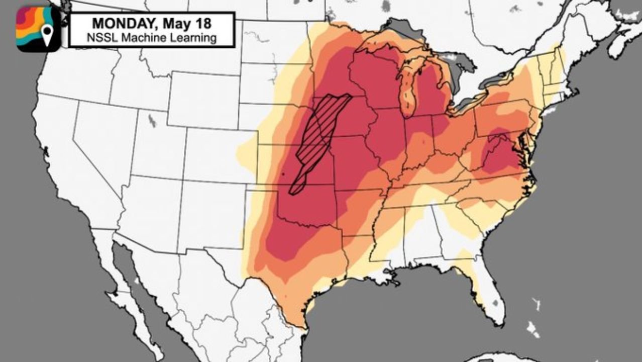
Where the Highest Risk Is Focused
The machine learning severe weather model for Monday, May 18 shows the highest risk concentrated in a hatched zone centered over Illinois, Missouri and parts of Indiana:
- The deepest red and hatched zone on the Monday, May 18 outlook map is centered over Illinois and extending into Indiana and Missouri, indicating the highest probability of significant severe weather including destructive hail and strong tornadoes for communities including Chicago, Galesburg, Springfield, Sedalia and Davenport.
- Fort Wayne, Indiana and Detroit, Michigan fall within the broader severe weather risk zone on the northeastern edge of the outlook, where storms pushing northeastward through Illinois and Indiana could still carry destructive hail and damaging wind potential as they approach the Great Lakes.
- Fayetteville, Arkansas and Fort Smith, Arkansas are included near the southern end of the supercell zone, where the dryline interaction with Gulf moisture will be most pronounced on Monday afternoon.
- Wichita, Kansas and Topeka, Kansas sit within the supercell initiation zone on the western edge of the outlined severe risk area for Monday, May 18.
The Instability Picture
A broad zone of moderate to extreme thunderstorm instability, labeled as storm fuel on the Monday, May 18 atmospheric setup map, covers the entire risk corridor from Texas and Oklahoma northeastward through Missouri, Illinois and Indiana:
- Moderate to extreme instability means the atmosphere is loaded with the heat, humidity and energy that thunderstorms need to grow tall, intense and long-lived. When this level of instability combines with the strong wind shear from the upper-level disturbance on Monday, the result is an environment highly favorable for supercells capable of all severe weather hazards.
- The instability zone extends from Texas and Oklahoma northward through Kansas, Missouri, Illinois and Indiana, meaning the fuel for severe storm development will be available across a very large area on Monday, May 18.
- Machine learning models are described as rather bullish with this severe weather episode, meaning computer guidance is strongly signaling a significant event rather than a marginal or borderline day.
What Monday Could Look Like in Practice
Based on the current setup, Monday, May 18 has the ingredients for an active and potentially memorable severe weather day across the Plains, Corn Belt and Upper Midwest:
- Storms are expected to fire during the afternoon hours of Monday, May 18 as daytime heating combines with the approaching cold front and dryline to trigger convection across Kansas, Oklahoma and Missouri.
- Initial discrete supercells developing during the afternoon will pose the greatest tornado and destructive hail risk before storms potentially consolidate into a damaging wind-producing line or cluster during the evening hours.
- The event will likely affect communities from the Kansas and Oklahoma dryline all the way northeast through Chicago, Fort Wayne and Detroit before the system pushes off to the east overnight.
What to Do Before Monday
Residents across Kansas, Oklahoma, Missouri, Illinois, Indiana and Michigan have several days to prepare before this potentially significant event arrives:
- Enable severe thunderstorm and tornado alert notifications on your phone now and verify your household shelter plan before Monday, May 18 arrives.
- Monitor daily forecast updates through Sunday, May 17 as storm timing, the specific highest-risk zones and exact threat details will come into much sharper focus in the 24 to 48 hours before the event.
- Have a shelter plan ready at home, at work and for any outdoor activities planned for Monday across Wichita, Topeka, Kansas City, St. Louis, Chicago, Fort Wayne and Detroit.
WaldronNews.com will continue tracking this potentially big severe weather day across Kansas, Oklahoma, Missouri, Illinois, Indiana and Michigan including Wichita, Topeka, St. Louis, Chicago, Fort Wayne and Detroit and will provide updates as destructive hail, damaging winds and tornado details develop ahead of Monday, May 18.