
Indiana, Illinois, Ohio and Michigan Face Rain and Storm System Friday May 22 Through Saturday May 23 With Indy 500 Race Day Morning Looking Dry But Afternoon Chances Possible
INDIANAPOLIS, Indiana — High confidence exists for a rain and storm system pushing through Indiana, Illinois, Ohio and Michigan from Friday, May 22 through at least Saturday morning, May 23, 2026. The critical question for Indy 500 fans is simple: how fast does it clear before Race Day Sunday, May 24?
Race Day morning currently appears dry. But Sunday afternoon storm chances cannot yet be ruled out.
The Three-Phase Weekend Breakdown
Friday May 22 into Saturday May 23 is the wet window. A high-confidence rain and storm system pushes through the region affecting Indianapolis, Chicago, Columbus, Detroit, Cincinnati, Louisville and St. Louis. Plan for a rainy start to the holiday weekend across all these cities.
Saturday May 23 afternoon is the pivot point. How quickly this system exits will determine everything about Sunday. A fast-moving system means a larger dry gap. A slow system means lingering clouds and storm chances push into Race Day afternoon.
Sunday May 24 morning currently looks dry for Indianapolis and the surrounding region. Race morning activities appear clear based on current data, though this will need daily monitoring through Friday.
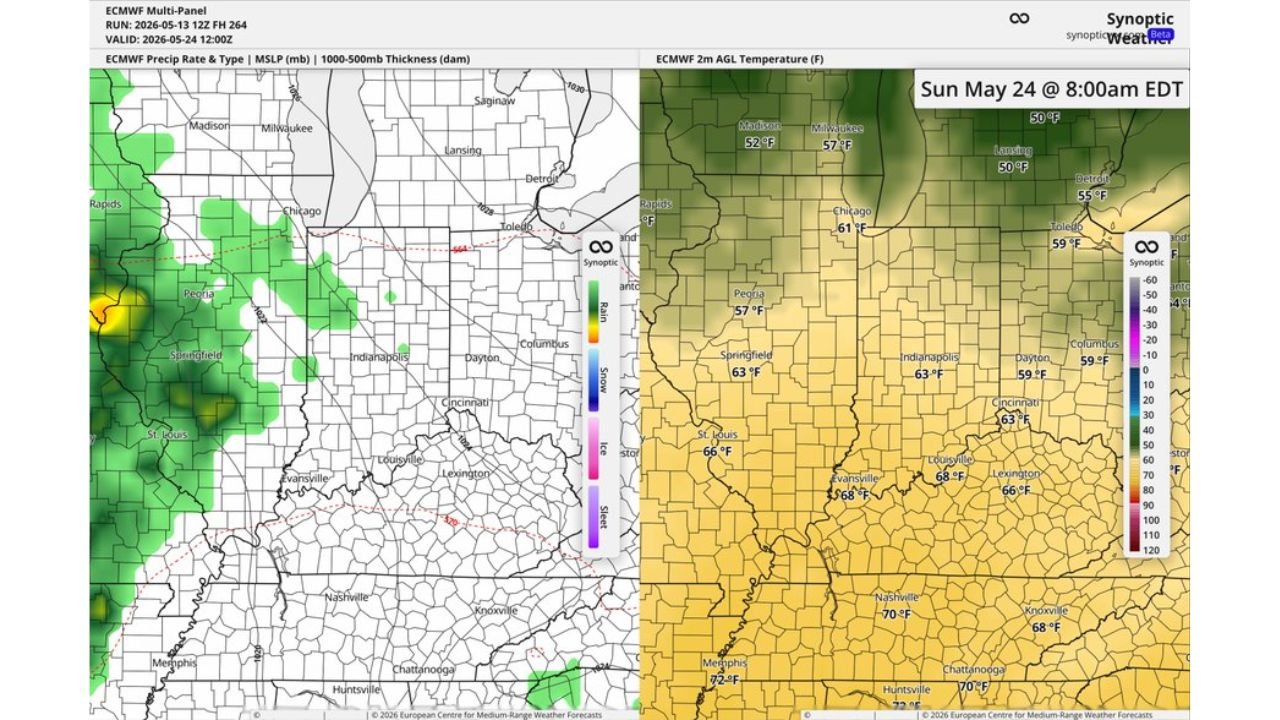
Sunday May 24 Morning Temperatures at 8:00 AM EDT
| City | Temperature |
|---|---|
| Madison, Wisconsin | 52 F |
| Milwaukee, Wisconsin | 57 F |
| Lansing, Michigan | 50 F |
| Detroit, Michigan | 55 F |
| Chicago, Illinois | 61 F |
| Toledo, Ohio | 59 F |
| Peoria, Illinois | 57 F |
| Springfield, Illinois | 63 F |
| Indianapolis, Indiana | 63 F |
| Dayton, Ohio | 59 F |
| Columbus, Ohio | 59 F |
| Cincinnati, Ohio | 63 F |
| Louisville, Kentucky | 68 F |
| Lexington, Kentucky | 66 F |
| Evansville, Indiana | 68 F |
| St. Louis, Missouri | 66 F |
| Nashville, Tennessee | 70 F |
| Memphis, Tennessee | 72 F |
| Knoxville, Tennessee | 68 F |
| Chattanooga, Tennessee | 68 F |
| Huntsville, Alabama | 72 F |
The Indy 500 Afternoon Question
Morning looks manageable at 63 F in Indianapolis. The real watch period is Sunday afternoon, May 24 once temperatures warm and the atmosphere has had time to destabilize following the departing system.
Forecasters note the European model data may be too aggressive with precipitation for this period. That means the dry gap on Sunday could be larger than currently shown. However, some afternoon storm chances remain on the table and cannot yet be dismissed for Race Day.
What to Do Before the Weekend
Check forecast updates daily starting Thursday, May 21 as confidence in the Sunday afternoon picture will sharpen considerably in the 24 to 48 hours before Race Day. Pack layers for the cool 63 F morning in Indianapolis and be prepared for the afternoon picture to change as the system timing becomes clearer.
WaldronNews.com will continue tracking the Friday May 22 through Saturday May 23 storm system and Indy 500 Race Day weather across Indiana, Illinois, Ohio and Michigan and will provide updates as Sunday, May 24 afternoon storm chances and dry gap timing develop.