
Kansas, Nebraska, South Dakota, Colorado and Montana Face Red Flag Fire Warnings While Kansas Faces Severe Thunderstorms With Large Hail and Damaging Winds Thursday May 14 Into Friday May 15
WICHITA, Kansas — A dangerous dual threat is unfolding across the Great Plains and central Rockies from Thursday, May 14 into Friday, May 15, 2026. Red Flag Warnings are in effect across large portions of Kansas, Nebraska, South Dakota, Colorado and Montana as gusty winds and low relative humidity create critical fire weather, while severe thunderstorms with large hail and damaging wind gusts are possible over the central Plains through this weekend.
The weather map valid 8:00 AM EDT Thursday, May 14 through 8:00 AM EDT Friday, May 15 shows the severe thunderstorm zone centered directly over Kansas, outlined in yellow hatching on the national forecast map.
Where Red Flag Warnings Are Active Right Now
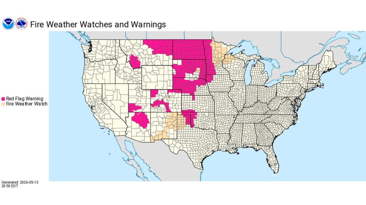
The Fire Weather Watches and Warnings map generated at 8:50 PM EDT Wednesday, May 13 shows an expansive Red Flag Warning zone across the Great Plains and Rockies:
The deepest Red Flag Warning coverage shown in pink covers a massive continuous zone stretching from Montana and South Dakota southward through Nebraska and into Kansas and Oklahoma, with additional Red Flag Warning areas across portions of Colorado and Utah. Fire Weather Watch zones shown in tan surround portions of Colorado, Kansas and Oklahoma where conditions are expected to reach critical levels in the coming days.
A Red Flag Warning means that critical fire weather conditions are either occurring now or will occur shortly. Any fire that starts under Red Flag conditions can spread rapidly and become extremely difficult or impossible to control.
What Is Creating the Fire Danger
Two ingredients are driving the critical fire weather across the Great Plains and Great Basin Thursday into Friday. Gusty winds are the first problem, providing the oxygen fires need to spread rapidly across dry terrain. Low relative humidity is the second, pulling moisture out of vegetation and turning grasses and shrubs into highly combustible fuel that can ignite from a single spark.
Together these conditions create some of the most dangerous fire weather of the year across Kansas, Nebraska, South Dakota, Colorado and Montana. Anyone in these states should avoid all outdoor burning, equipment use that produces sparks, and any open flames near vegetation on Thursday, May 14 and Friday, May 15.
Severe Thunderstorms Possible Over Kansas Thursday
While fire weather dominates the western and northern Plains, a separate severe thunderstorm threat is developing directly over Kansas on Thursday, May 14:
The yellow hatched severe thunderstorm zone on the national weather map is centered squarely over Kansas, where large hail and damaging wind gusts are possible during the afternoon and evening hours. This threat extends into the central Plains and continues through the weekend as additional storm systems move through the region.
Large hail can destroy vehicles and damage roofs within minutes. Damaging wind gusts can snap trees, down power lines and cause widespread property damage across affected Kansas communities. Residents across Kansas should have weather alerts active throughout Thursday afternoon and evening and be prepared to take shelter immediately if a severe thunderstorm warning is issued.
Rain and Thunderstorms Across the Midwest and Northeast
Beyond the fire weather and severe storm zones, a broad rain and thunderstorm shield is moving through the Midwest and Northeast during the Thursday, May 14 through Friday, May 15 valid period. Minnesota, Wisconsin, Michigan, Iowa, Illinois, Indiana, Ohio, Pennsylvania, New York, Vermont, New Hampshire, Massachusetts, Connecticut, Rhode Island and Maine all fall within the rain and thunderstorm zone on the national map.
Mixed precipitation is also shown across portions of Washington state and the Pacific Northwest as a separate system moves through the region Thursday.
Do Not Start Any Outdoor Fires Thursday
For residents across the Red Flag Warning zones the message is direct. Do not start any outdoor fire on Thursday, May 14 or Friday, May 15 under any circumstances. Report any smoke you see immediately to local fire authorities. If you see a fire spreading, leave the area immediately and call 911.
WaldronNews.com will continue tracking Red Flag Warnings across Kansas, Nebraska, South Dakota, Colorado and Montana and severe thunderstorm chances across the central Plains and will provide updates as fire weather conditions and storm details develop through Friday, May 15.