
Super El Nino on the Way and What It Means for Washington DC, the Southeast and North America With Cool and Wet Conditions Possible While the North Runs Warm and Dry
WASHINGTON, DC — Chatter about an incoming Super El Nino has been growing, and while comparisons to the devastating 1877 event sound alarming, the likely impacts on North America and the Washington DC region are very different from what that historic event did globally in terms of droughts and famine. Here is what a typical El Nino pattern actually means for local American communities.
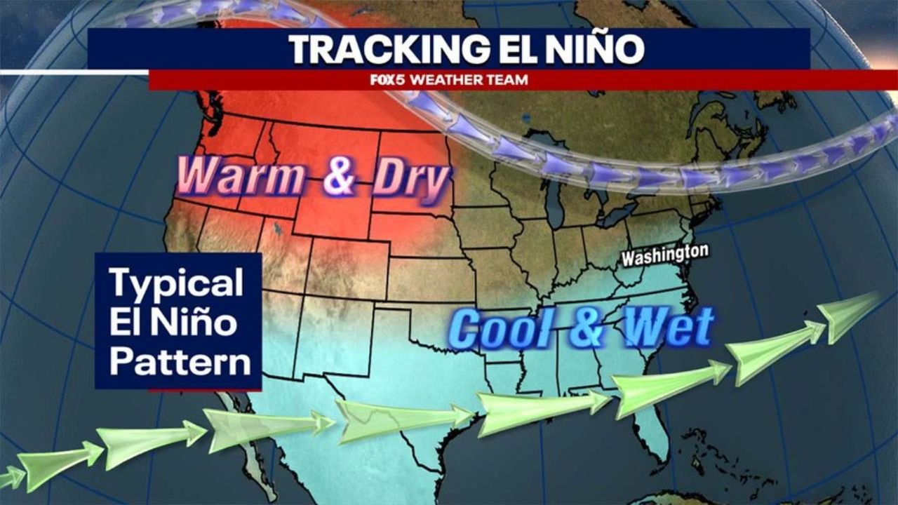
The pattern is not one-size-fits-all. El Nino splits North America into two very distinct weather zones, and which side of that line you live on determines whether the coming months bring warmth and drought or cool and wet conditions.
The Two Americas Under El Nino
The typical El Nino pattern shown on the tracking map divides North America cleanly along a diagonal boundary running roughly from the Pacific Northwest southeastward toward Washington DC:
The Warm and Dry Zone covers the northern half of the country including the Pacific Northwest, the northern Plains, the Great Lakes region and Canada. Under a typical El Nino pattern these areas see warmer than normal temperatures and below normal precipitation. For communities already dealing with drought across the northern Plains and Great Lakes, a Super El Nino would likely intensify and extend those dry conditions rather than provide relief.
The Cool and Wet Zone covers the southern half of the country from the Southwest through Texas, the Gulf Coast, the Southeast and up the East Coast toward Washington DC. Under a typical El Nino this zone sees cooler than normal temperatures and above normal precipitation. Moisture flowing in from the Pacific and Gulf of Mexico on strengthened jet stream winds fuels wetter conditions across this entire southern corridor.
What This Means for Washington DC
Washington DC sits near the boundary between the warm-dry north and the cool-wet south, which puts the region in an interesting position under a Super El Nino:
The cool and wet arrows on the tracking map point directly toward Washington, suggesting the DC region leans toward the cooler and wetter side of the El Nino pattern rather than the warm and dry side. For a city that has been running nearly 4 inches below normal rainfall in 2026 and dealing with expanding drought conditions across Maryland and Virginia, a shift toward above-normal precipitation under El Nino influence would be genuinely significant for drought recovery.
Cooler than normal temperatures across the DC region under a Super El Nino pattern would also moderate the intense heat spikes that have affected the Mid-Atlantic in recent summers, though periods of above-normal warmth would still be possible given the overall warming background of the climate.
Super El Nino vs Regular El Nino
The word Super attached to El Nino refers to an unusually strong warming of Pacific Ocean surface temperatures beyond what a typical El Nino produces. The stronger the Pacific warming the more forcefully the typical El Nino pattern is expressed across North America:
A regular El Nino nudges the jet stream and moisture patterns in the directions shown on the map. A Super El Nino does the same thing but with significantly more force, meaning the warm-dry signal in the north becomes more extreme and the cool-wet signal in the south becomes more pronounced and persistent through the affected season.
For the Southeast, Gulf Coast and East Coast including Washington DC, a Super El Nino historically means more frequent storm systems, higher rainfall totals and a greater likelihood of a cooler than normal winter and spring compared to neutral or La Nina years.
What Communities in Each Zone Should Expect
The practical takeaways differ significantly depending on where you live:
If you are in the Pacific Northwest, northern Plains or Great Lakes region sitting in the warm and dry zone, a Super El Nino is not good news for water supplies, agriculture or wildfire risk. Drought conditions that have already developed across parts of the northern Plains could worsen significantly if the Super El Nino pattern verifies as forecast.
If you are in Washington DC, Maryland, Virginia, the Southeast, Texas or the Gulf Coast sitting in the cool and wet zone, a Super El Nino historically brings more rain, more storm systems and cooler temperatures. For the DC region currently running nearly 4 inches below normal for 2026, this shift could not come at a better time for drought recovery if the pattern verifies.
WaldronNews.com will continue tracking the developing Super El Nino pattern and its potential impacts across Washington DC, the Southeast and North America and will provide updates as ocean temperature trends and seasonal forecast signals develop.