
Florida Confirms Two EF-0 Tornadoes in Pasco County With 85 mph Winds as Hudson Tornado Tracks 1.19 Miles and Shady Hills Tornado Tracks 0.69 Miles on May 12
HUDSON, Florida — Two tornadoes have been confirmed by the National Weather Service in Pasco County, Florida on Tuesday, May 12, 2026, both rated EF-0 with peak winds of 85 mph and zero fatalities or injuries reported. The Hudson tornado and the Shady Hills tornado struck within 30 minutes of each other along the Pasco County coast, confirming what storm chasers reported in real time during Tuesday’s active weather event.
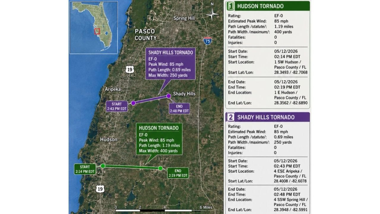
The Two Tornadoes Side by Side
| Hudson Tornado | Shady Hills Tornado | |
|---|---|---|
| Rating | EF-0 | EF-0 |
| Peak Wind | 85 mph | 85 mph |
| Path Length | 1.19 miles | 0.69 miles |
| Max Width | 400 yards | 250 yards |
| Start Time | 2:14 PM EDT | 2:43 PM EDT |
| End Time | 2:19 PM EDT | 2:48 PM EDT |
| Duration | 5 minutes | 5 minutes |
| Fatalities | 0 | 0 |
| Injuries | 0 | 0 |
Tornado 1: Hudson
The Hudson tornado touched down at 2:14 PM EDT on Tuesday, May 12 at a location 1 SW Hudson in Pasco County, Florida at coordinates 28.3493 / -82.7068. It tracked 1.19 miles at a maximum width of 400 yards before lifting at 2:19 PM EDT near 1 E Hudson at coordinates 28.3562 / -82.6890.
Five minutes. 1.19 miles of ground track. 400 yards wide at its maximum. An EF-0 tornado with 85 mph peak winds is strong enough to break tree branches, damage fences, destroy signage and cause minor damage to poorly constructed structures within its path. The Hudson tornado was the longer-tracked and wider of the two confirmed Pasco County tornadoes from Tuesday.
Tornado 2: Shady Hills
The Shady Hills tornado touched down at 2:43 PM EDT, just 24 minutes after the Hudson tornado lifted, starting near 4 ESE Aripeka in Pasco County at coordinates 28.4008 / -82.6078. It tracked 0.69 miles at a maximum width of 250 yards before ending at 2:48 PM EDT near 4 SSW Spring Hill at coordinates 28.3948 / -82.5991.
The Shady Hills tornado was narrower and shorter-tracked than Hudson but equally intense at 85 mph peak winds. Both tornadoes share the same 5-minute duration and identical wind speed ratings, suggesting they were produced by the same storm system moving through Pasco County during Tuesday afternoon’s severe weather event.
What EF-0 Means
An EF-0 tornado sits at the bottom of the Enhanced Fujita scale used to rate tornado intensity in the United States. The scale runs from EF-0 at the weakest to EF-5 at the most violent. At 85 mph, an EF-0 tornado is capable of causing light damage including broken tree branches, damaged gutters, shallow-rooted trees pushed over and minor damage to roof shingles and siding on structures in the direct path.
While EF-0 is the lowest rating, an 85 mph tornado is still a genuine and dangerous natural event. The fact that both Pasco County tornadoes produced zero fatalities and zero injuries on Tuesday, May 12 is a positive outcome given that both storms tracked through areas with residential development.
Storm Chaser Confirmation
The Shady Hills tornado was intercepted in real time by a storm chaser who was inside the tornado during the event. The National Weather Service confirmation of both tornadoes on Wednesday, May 13 validates what the storm chaser reported during Tuesday’s chase, concluding a notable severe weather day for Pasco County, Florida.
WaldronNews.com will continue tracking tornado confirmation reports and damage surveys across Pasco County, Florida including Hudson, Shady Hills, Aripeka and Spring Hill and will provide updates as additional survey results from Tuesday, May 12 develop.