
Colorado Faces Snow and Rain Sunday Night May 17 Into Monday May 18 With Tuesday Morning Lows Dropping to the 20s and 30s Across the Mountains and Plains
DENVER, Colorado — A significant pattern change is coming to Colorado this weekend, with rain and snow possible Sunday night, May 17 into Monday morning, May 18, 2026, followed by a hard temperature crash that could send Tuesday morning, May 19 lows into the 20s across the mountains and higher terrain and the 30s across much of the Colorado plains and foothills.
This is enough of a cold snap to threaten late-season crops, gardens and sensitive plants across Colorado and residents need to prepare now while time remains.
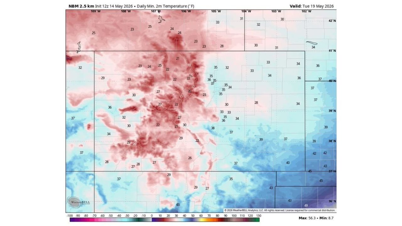
Tuesday Morning Low Temperature Map
The minimum temperature forecast valid Tuesday, May 19 tells the story clearly. The coldest readings are concentrated across the Colorado high country in the deep pink zone with readings dropping as low as 17 to 22 degrees F across the highest terrain:
| Zone | Tuesday Morning Low |
|---|---|
| Colorado high mountain terrain | 17 to 22 F |
| Central Colorado mountains and foothills | 22 to 27 F |
| Western Colorado slopes | 23 to 30 F |
| Colorado plains and eastern sections | 28 to 37 F |
| Far southeastern Colorado | 37 to 39 F |
| Lowest elevation eastern plains | 34 to 38 F |
The minimum across the entire map reaches 8.7 degrees F in the coldest mountain locations, while the warmest readings on the map stay around 56 F in the lowest desert elevations far from Colorado.
Snow and Rain Sunday Night Into Monday Morning
Before the cold arrives, a storm system will bring rain and snow to Colorado starting Sunday night, May 17 and continuing into Monday morning, May 18. The combination of precipitation followed immediately by a hard temperature drop means:
Roads that are wet from Sunday night rain could refreeze Monday morning as temperatures crash. Snow accumulation at higher elevations and mountain passes is likely with this system. The wet ground combined with 20s and 30s on Tuesday morning creates ideal conditions for a killing frost across any gardens or crops that survived the winter and early spring across Colorado.
Frost and Freeze Warning for Gardeners
Mid-May frosts in Colorado are not unheard of but a drop to the 20s at this point in the season can cause serious damage to plants that have already leafed out and are actively growing. At 20 to 27 degrees F, even established perennials, fruit trees in bloom and vegetable garden starts can suffer significant or total foliage loss in a single overnight freeze event.
Colorado gardeners and farmers should take action before Sunday night, May 17 to protect vulnerable plants. Cover all sensitive vegetation with frost cloth or plastic sheeting before sunset Sunday. Move all potted plants indoors before Sunday night temperatures begin to fall. Delay any new planting until temperatures recover above freezing consistently after this system passes.
What Comes After Tuesday
After the cold snap bottoms out Tuesday morning, May 19, temperatures should gradually recover as the storm system exits Colorado and the pattern moderates heading into later next week. But the 17 to 37 degree Tuesday morning low range across the state makes this one of the more significant late-season cold intrusions Colorado has seen in mid-May 2026.
WaldronNews.com will continue tracking snow chances, rain timing and the Tuesday, May 19 hard freeze threat across Colorado and will provide updates as storm timing, snow totals and minimum temperature details develop through Tuesday morning, May 19.