
Iowa, Kansas, Missouri and Illinois Face Slight Risk Severe Storms With Large Hail and Tornadoes Friday May 15 While North Dakota, South Dakota and New Mexico Face Critical Fire Weather
DES MOINES, Iowa — Friday, May 15, 2026 brings a double threat across a large portion of the central United States, with a Slight Risk severe weather outbreak possible across Iowa, Kansas, Missouri and Illinois while critical to elevated fire weather conditions develop simultaneously across North Dakota, South Dakota, Nebraska, New Mexico and surrounding areas.
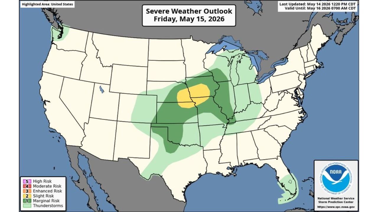
Both outlooks were last updated at 12:20 PM CDT and 2:56 PM CDT Wednesday, May 14 and are valid through 7:00 AM CDT Saturday, May 16.
The Severe Weather Picture Friday
The Severe Weather Outlook valid Friday, May 15 shows three nested risk zones centered over the central Plains and Midwest:
The Slight Risk zone shown in yellow on the map is centered over Iowa and extending into portions of Kansas, Missouri and Illinois, where large to very large hail, wind damage and tornadoes are all possible Friday and into Saturday. Slight Risk means scattered severe storms are expected rather than isolated or widespread, representing a meaningful threat for the outlined area.
Surrounding the Slight Risk core is a broader Marginal Risk zone covering a much larger area from Oklahoma and Texas northward through Missouri, Illinois, Indiana and into Michigan. A thunderstorm zone extends even further outward across the Great Lakes and Mid-South regions.
The three-level nesting of risk zones from Marginal outward to Slight in the core tells forecasters that the worst storms will be concentrated over Iowa and central Kansas through Missouri while a broader but lower-level threat exists across a much wider region.
Fire Weather: Two Different Levels of Danger
The Fire Weather Outlook valid Friday, May 15 shows a sharp contrast between two fire weather zones:
Critical fire weather shown in pink covers a zone across New Mexico and extending into southern Colorado and the surrounding southern High Plains. Critical conditions mean gusty winds and very low humidity are combining to create dangerous rapid fire spread potential across New Mexico on Friday. Any fire that starts in this zone can become life-threatening and uncontrollable very quickly.
Elevated fire weather shown in tan covers a much broader zone across North Dakota, South Dakota, portions of Nebraska and a separate zone across Wyoming and Colorado. Elevated conditions are one level below critical but still represent meaningful fire danger across the Northern Plains and Upper Midwest on Friday due to gusty winds and low humidity.
The contrast between the severe storm threat over Iowa to the east and the fire weather threat over New Mexico and the Northern Plains to the west illustrates how a single weather system can simultaneously create completely opposite hazards across different parts of the country on the same day.
What Friday Looks Like State by State
Iowa is the epicenter of the severe weather threat on Friday, May 15, sitting inside the Slight Risk yellow zone with the highest probability of experiencing large hail, damaging winds and tornadoes during the afternoon and evening.
Kansas and Missouri fall within the Slight to Marginal Risk overlap zone, where severe storms capable of large hail and wind damage are possible but the tornado threat is somewhat lower than over the Iowa core.
Illinois and Indiana sit within the broader Marginal Risk area and face isolated severe storm chances as the system pushes eastward through Friday evening.
North Dakota and South Dakota face elevated fire weather across the Northern Plains, where gusty winds and low humidity will make any fire extremely difficult to control through Friday afternoon.
New Mexico carries the highest fire weather risk of any state on Friday, with critical conditions in place across the southern portion of the state through 7:00 AM CDT Saturday.
Nebraska and Wyoming share elevated fire weather conditions across portions of their western and central regions while also sitting on the western fringe of the broader severe storm threat zone.
Do Not Burn Friday Across the Fire Weather States
The message for North Dakota, South Dakota, Nebraska, Wyoming and New Mexico on Friday, May 15 is identical regardless of whether your area is under critical or elevated conditions. Do not start any outdoor fire. Do not operate equipment that produces sparks near dry vegetation. Report any smoke immediately. Leave the area and call 911 if you see a fire spreading.
Shelter Plan Needed for Iowa, Kansas, Missouri and Illinois
Friday afternoon and evening is the window when severe storms are most likely across the Iowa Slight Risk core. Have a shelter plan ready before Friday afternoon arrives. Enable all weather alert notifications. Know your interior shelter location at home and at work before the first storms fire.
WaldronNews.com will continue tracking the Friday, May 15 Slight Risk severe weather outbreak across Iowa, Kansas, Missouri and Illinois and critical fire weather across North Dakota, South Dakota and New Mexico and will provide updates as storm and fire weather details develop through Saturday, May 16.