
Central Plains and Upper Midwest Face Multi-Day Tornado Outbreak Possible Saturday May 16 Through Tuesday May 19 Peaking Sunday and Monday Across Kansas, Nebraska, Iowa and Missouri
KANSAS CITY, Kansas — A potential multi-day tornado outbreak is taking shape across the central United States with six consecutive days of severe weather and tornado potential running from Thursday, May 14 through Tuesday, May 19, 2026. The outbreak is expected to peak Sunday, May 17 and Monday, May 18 across the central and southern Plains into the Upper Midwest.
This is not a routine severe weather week. Forecasters are using the phrase full-blown tornado outbreak for the Saturday evening through Tuesday morning window across Kansas, Nebraska, Iowa and Missouri.
Six Days of Severe Weather: Day by Day Risk Zones
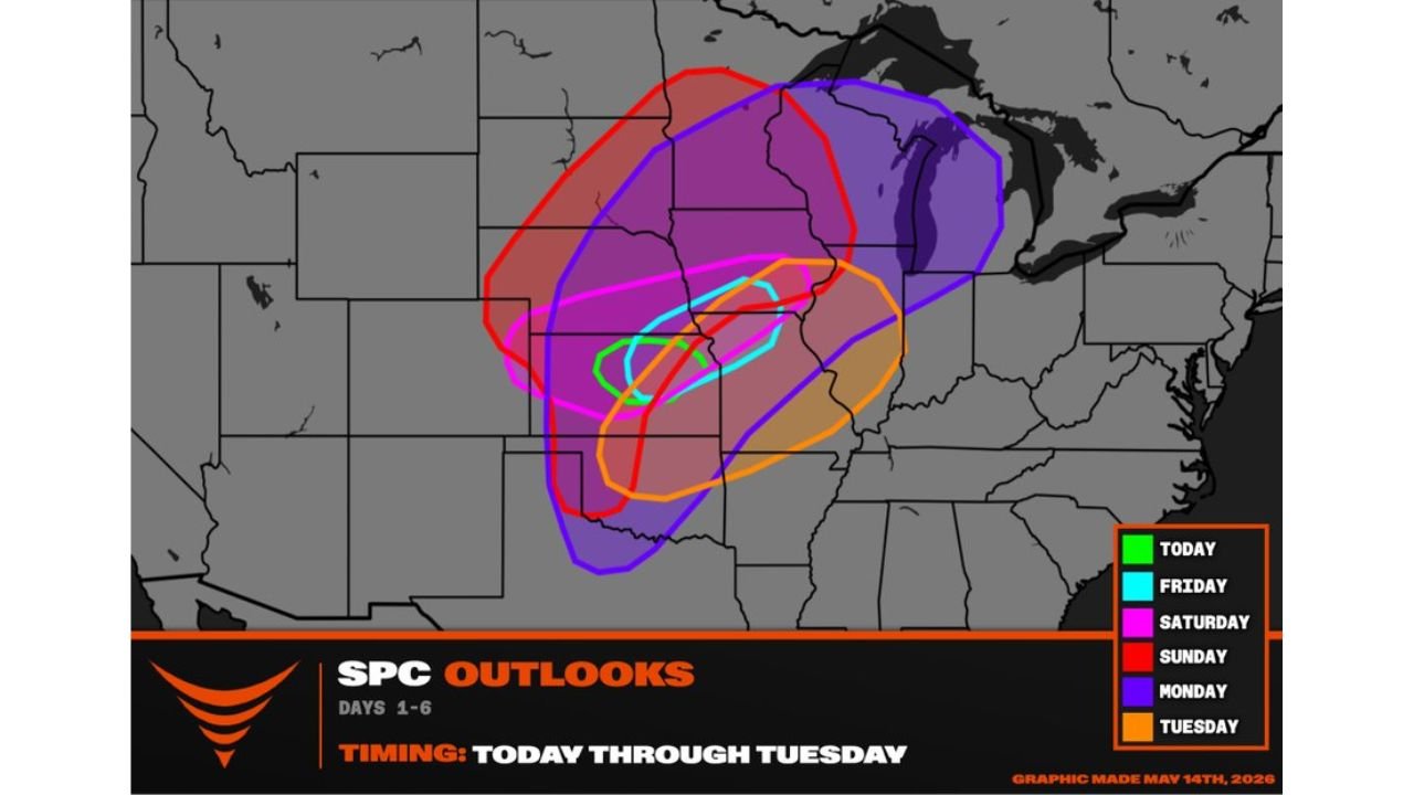
The color-coded outbreak map shows how the severe weather threat shifts northward and eastward each day from Thursday through Tuesday:
| Day | Color | Primary Risk Zone |
|---|---|---|
| Thursday May 14 (Today) | Green | Central Kansas, gorilla hail threat |
| Friday May 15 | Cyan | Central Kansas and Nebraska corridor |
| Saturday May 16 | Magenta | Kansas, Nebraska, Iowa, Missouri |
| Sunday May 17 | Red | Broadest zone, central Plains to Upper Midwest |
| Monday May 18 | Red/Purple | Upper Midwest, Great Lakes |
| Tuesday May 19 | Orange | Missouri, Oklahoma, Arkansas corridor |
The overlapping zones make one thing immediately clear. The same general area from central Kansas northeastward through Iowa and Missouri faces repeated rounds of severe weather across multiple consecutive days rather than one isolated event. Communities in this corridor may face tornado threats on Saturday, Sunday and Monday with little recovery time between events.
What Makes This Setup Different
The phrase gorilla hail appearing in today’s Thursday forecast for central Kansas refers to baseball-size or larger hail, the kind that does not just dent vehicles but punches through windshields, strips bark off trees and causes catastrophic roof damage in minutes. That is the opening act of a six-day sequence.
As the pattern evolves through the weekend, the dominant threat shifts from large hail to tornadoes. The Saturday evening through Tuesday morning window has forecasters specifically flagging a full-blown tornado outbreak, meaning the atmosphere will be configured to support multiple significant tornadoes across the central and southern Plains and into the Upper Midwest over an extended multi-day period.
A multi-day outbreak is more dangerous than a single outbreak day for one critical reason. Emergency resources, shelters and communities get tested repeatedly. Damage from Saturday tornadoes may leave people in compromised structures when Sunday tornadoes arrive. Power outages from Saturday storms reduce warning reception for Sunday and Monday events. This compounding effect is why forecasters treat multi-day outbreaks with particular urgency.
The Peak: Sunday May 17 and Monday May 18
The red zone on the outbreak map covering Sunday is the largest single-day risk area in the entire six-day sequence, stretching from the southern Plains northward and eastward into the Upper Midwest and toward the Great Lakes. Monday’s purple zone shifts slightly northward and eastward but remains enormous in geographic scope.
Communities across Kansas, Nebraska, Iowa, Missouri and into Illinois, Indiana and Michigan all fall within the peak outbreak risk zone for Sunday and Monday. This is the core of what forecasters are watching most closely as the week progresses.
Tuesday’s Trailing Threat
Even after the Sunday and Monday peak, Tuesday, May 19 brings an orange risk zone covering Missouri, Oklahoma and the Arkansas corridor. The outbreak does not end cleanly. It trails southeastward as the storm system exits the region, keeping severe weather potential alive into the early portion of next week across communities that may already be dealing with damage from the preceding days.
What Every Resident From Kansas to Michigan Should Do Right Now
The window to prepare comfortably is Thursday and Friday before the outbreak ramps up Saturday evening. Here is the priority list:
Charge all devices and battery packs fully before Saturday. Power outages during a multi-day outbreak can leave people without warning capability for subsequent storm days. Identify your shelter location at home and have a plan for work and school on Monday. If you live in a mobile or manufactured home anywhere from Kansas through Iowa or Missouri, make arrangements now to shelter in a permanent structure during Saturday, Sunday and Monday storm windows. Do not wait until a tornado watch is issued to find alternate shelter because by then storm development may already be underway.
Know the difference between a Watch and a Warning. A Tornado Watch means conditions are favorable for tornadoes across a large area and you should be prepared to take shelter quickly. A Tornado Warning means a tornado has been confirmed or is indicated on radar for a specific location and you must take shelter immediately.
WaldronNews.com will continue tracking this multi-day tornado outbreak potential across Kansas, Nebraska, Iowa, Missouri and the Upper Midwest and will provide daily updates as tornado risk zones, storm timing and outbreak intensity develop through Tuesday, May 19.