
Kansas, Nebraska, Iowa, Missouri, Oklahoma, Texas, Illinois, Wisconsin and Michigan Face Likely Severe Weather Outbreak With Tornadoes and Very Large Hail Monday May 18 From Wichita to Chicago
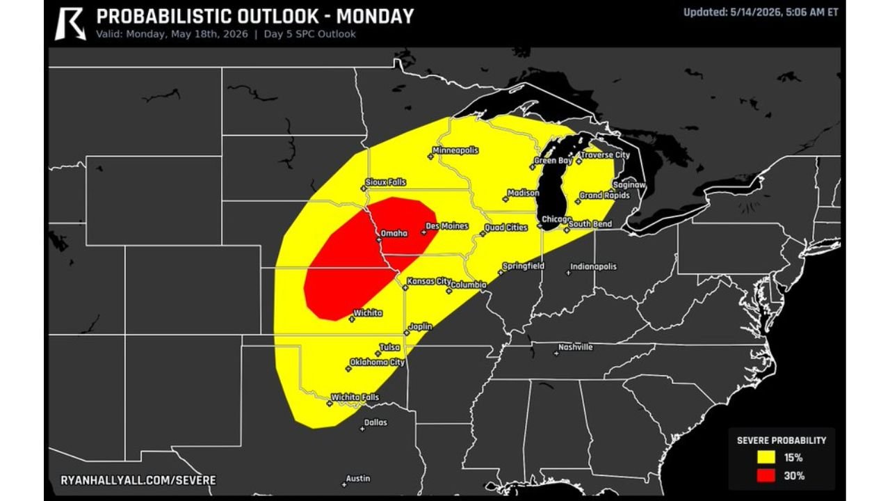
WICHITA, Kansas – A likely severe weather outbreak is shaping up for Monday, May 18, with forecasters expressing unusually high confidence this far in advance. Tornadoes and very large hail are the primary threats from Kansas through Wisconsin, with a 30% severe weather probability zone centered on Omaha, Wichita and Kansas City.
Why Monday Looks So Dangerous
It is rare to see this level of forecast confidence five days out, but the atmospheric setup for Monday, May 18 is strongly leaning toward a significant severe weather event. The threat stretches from Oklahoma and Texas in the south all the way north through Wisconsin and east into Michigan. The core of the highest risk sits across a broad area from Wichita north through Omaha and into Sioux Falls, where a 30% probability of severe weather is already being highlighted.
The Two Risk Zones You Need to Know
The outlook map shows two distinct probability zones for Monday, May 18:
- The 30% severe weather zone shown in red covers the highest-risk corridor and includes Wichita, Kansas City, Omaha, Des Moines and Columbia. This is where tornadoes and very large hail pose the greatest threat.
- The 15% severe weather zone shown in yellow extends the threat significantly wider, reaching Sioux Falls, Minneapolis, Madison, Green Bay, Traverse City, Saginaw, Grand Rapids, South Bend, Indianapolis, Springfield, Joplin, Tulsa, Oklahoma City, Wichita Falls and Dallas.
Cities Facing the Highest Tornado and Hail Risk
Communities inside or near the 30% red zone face the most serious conditions on Monday, May 18:
- Omaha, Nebraska sits near the center of the highest-risk zone and faces a real tornado and very large hail threat Monday.
- Wichita, Kansas is squarely inside the 30% corridor and should prepare for a dangerous afternoon and evening.
- Kansas City and Columbia, Missouri both fall within the core risk area and could see supercell thunderstorms capable of producing tornadoes.
- Des Moines, Iowa and Quad Cities are also within or near the highest-risk zone and should monitor conditions closely through Monday.
Wider Threat Reaching the Great Lakes
The 15% severe weather zone covers an enormous area stretching into the Great Lakes region:
- Chicago, Illinois falls within the threat area and metro residents should have weather alerts enabled heading into Monday.
- Green Bay, Traverse City, Saginaw and Grand Rapids, Michigan are all highlighted, meaning the outbreak could push deep into the upper Midwest.
- Madison and Milwaukee area residents in Wisconsin are also inside the 15% zone and should not dismiss this threat.
- South Bend and Indianapolis, Indiana round out the eastern edge of the risk area.
What You Should Do Before Monday
Anyone from Dallas and Oklahoma City north through Omaha and Sioux Falls and east to Chicago and Grand Rapids needs to have a severe weather plan ready before Monday, May 18. Know your shelter location now. Keep weather alert notifications turned on all day Monday. This outbreak has the potential to be significant and the window to prepare is shrinking.
WaldronNews.com will continue tracking this severe weather outbreak across Kansas, Nebraska, Iowa, Missouri, Oklahoma, Texas, Illinois, Wisconsin and Michigan and will provide updates as tornado and hail threat details develop for Monday, May 18.