
Minnesota and Wisconsin Face 80% Chance of 2 Inch Plus Rainfall Sunday May 17 Through Tuesday May 19 Including Minneapolis, Lakeville, Rochester and Winona With Some Areas Seeing Near 4 Inches
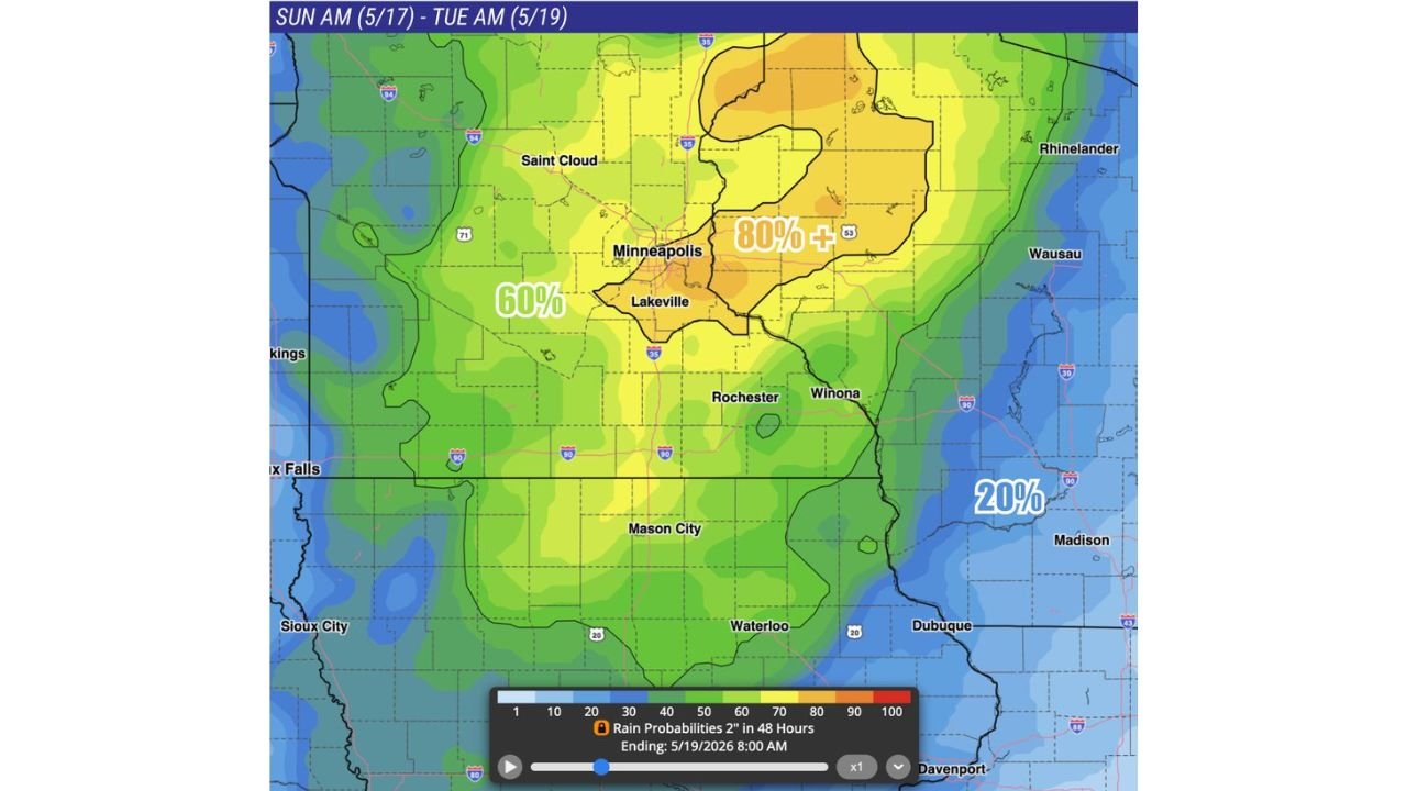
MINNEAPOLIS, Minnesota – An 80% or greater probability of 2 inches or more of rainfall is bearing down on a large portion of Minnesota between Sunday morning, May 17 and Tuesday morning, May 19. Some localized streaks could approach 4 inches, closing out an already above-normal precipitation period for the region.
Who Faces the Highest Rainfall Risk
The 80% or greater probability zone is the core of the heaviest rainfall threat and covers a significant portion of central and eastern Minnesota:
- Minneapolis and Lakeville, Minnesota sit squarely inside the 80% plus zone and face the highest likelihood of seeing 2 inches or more of rain between Sunday, May 17 and Tuesday, May 19.
- Rochester and Winona, Minnesota are also within the 80% plus corridor and should prepare for potentially significant rainfall totals through Tuesday morning, May 19.
- Saint Cloud, Minnesota falls within the broader threat area and faces a 60% probability of seeing 2 inches or more of rainfall during this same window.
The Wider 60% Zone
A large surrounding area carries a 60% probability of 2 inches or more of rain through Tuesday morning, May 19:
- Saint Cloud and communities across western and southern Minnesota fall within this 60% probability zone and should expect meaningful rainfall accumulations through the weekend and into early next week.
- Mason City and Waterloo sit near the southern edge of the rainfall threat zone through Tuesday, May 19.
- Sioux City and Dubuque are within the outer edges of the rainfall probability area during this period.
- Wausau, Rhinelander and Madison, Wisconsin sit within the eastern portions of the threat zone with a 20% probability of 2 inches or more through Tuesday morning, May 19.
What Nearly 4 Inches of Rain Means Locally
Localized streaks of approximately 4 inches of rainfall within a 48-hour window can overwhelm drainage systems, flood low-lying roads and fields, and cause rapid rises in streams and rivers. This rainfall event is closing out what has already been an above-normal precipitation period for the region, meaning the ground in many areas may have limited capacity to absorb additional rainfall quickly. Ponding on roads and flooded underpasses are realistic concerns for the Minneapolis and Lakeville areas through Tuesday morning, May 19.
Timing to Know
The entire rainfall event runs from Sunday morning, May 17 through Tuesday morning, May 19, giving this system a full 48-hour window to deliver heavy totals across Minnesota and into portions of Wisconsin. After this system moves through, the number of storm systems is expected to decrease significantly through June, making this a critical rainfall event for the region.
What You Should Do Before Sunday
Residents across Minneapolis, Lakeville, Rochester, Winona and Saint Cloud should clear storm drains near their property before Sunday morning, May 17. Avoid parking vehicles in low-lying areas or near drainage corridors through Tuesday, May 19. If roads are flooded, turn around and do not attempt to drive through standing water.
WaldronNews.com will continue tracking this 2 inch plus rainfall event across Minnesota and Wisconsin and will provide updates as rainfall totals and flood impacts develop through Tuesday morning, May 19.