
Iowa and Nebraska Face Baseball Size Gorilla Hail From Multiple Supercells This Evening Including Sioux City, Holstein, Mapleton, Estherville and Nebraska City With Low Tornado Threat
SIOUX CITY, Iowa – Multiple supercell thunderstorms producing baseball size gorilla hail have fired across western and northern Iowa this evening, Saturday, May 16. One monster supercell east of Sioux City is actively dropping baseball size hail right now, with a low but real tornado threat accompanying these storms.
What Is Gorilla Hail and Why It Matters
Gorilla hail is a term used by meteorologists to describe extremely large, destructive hail produced by exceptionally powerful supercell thunderstorms. Baseball size gorilla hail measures approximately 2.75 inches in diameter and is large enough to shatter vehicle windshields instantly, punch holes through roofs, destroy crops and seriously injure anyone caught outdoors. If you are in or near any of the highlighted storm areas this evening, get indoors and away from windows immediately.
Where the Supercells Are Firing Right Now
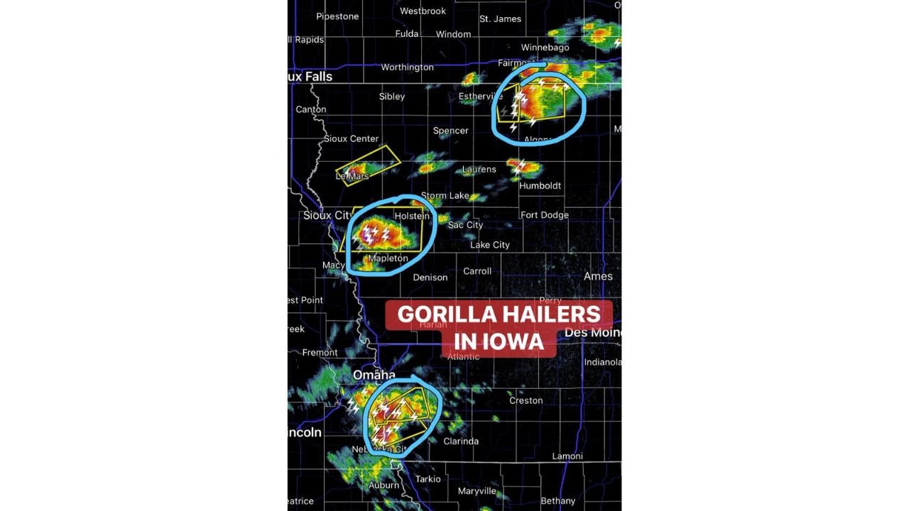
Three distinct supercell clusters are active across Iowa and Nebraska this Saturday evening, May 16:
- The monster supercell east of Sioux City, Iowa near Holstein and Mapleton is the most intense storm currently active and is confirmed dropping baseball size hail this evening. Sioux Center and Le Mars are also near this active storm cluster.
- A second supercell cluster is firing across northern Iowa near Estherville, Spencer, Algona, Sibley and Humboldt, producing large destructive hail with a low but non-zero tornado threat this evening.
- A third supercell is active near Nebraska City and Omaha, Nebraska, with Auburn and Tarkio also near this southern storm cluster producing gorilla hail this Saturday evening.
Cities That Need to Shelter Right Now
The following communities are in immediate danger from active gorilla hail producing supercells this Saturday evening, May 16:
- Holstein, Mapleton, Storm Lake, Sac City and Le Mars, Iowa are directly in the path of the monster supercell east of Sioux City and face baseball size hail impact right now.
- Estherville, Spencer, Algona, Sibley, Laurens, Humboldt and Fort Dodge, Iowa are threatened by the northern Iowa supercell cluster this evening.
- Nebraska City, Omaha and Lincoln, Nebraska face the southern supercell cluster with large destructive hail and a low tornado threat this Saturday evening.
- Harlan, Atlantic, Denison, Carroll and Clarinda, Iowa sit in the broader storm environment and should monitor conditions closely through this evening.
The Tornado Threat This Evening
While the primary hazard from these storms is baseball size gorilla hail, forecasters note there is a low but non-zero tornado threat with these supercells this Saturday evening, May 16. As winds increase in the lower atmosphere tonight, these supercells are expected to congeal into a larger complex of storms. Do not let the word low convince you to ignore the tornado risk. Have a shelter plan ready before storms reach your location.
What You Must Do Right Now
Anyone near Sioux City, Holstein, Mapleton, Estherville, Nebraska City or Omaha needs to be indoors in a sturdy structure right now. Move all vehicles into a garage or under solid cover immediately. Baseball size hail will total a vehicle in seconds. Stay away from windows and monitor weather alerts on your phone until all storm warnings expire for your area this evening.
WaldronNews.com will continue tracking these gorilla hail producing supercells across Iowa and Nebraska and will provide updates as hail reports, tornado warnings and storm movement develop throughout Saturday evening, May 16.