
Nebraska and Iowa Face Intense Tornado Potential Sunday May 17 Into Monday May 18 as Significant Severe Weather Outbreak Looks Like a Rather High End Event Across the Great Plains
LINCOLN, Nebraska – An intense tornado potential is building across eastern Nebraska into Iowa for Sunday, May 17 and peaking across the central and southern Great Plains on Monday, May 18. Forecasters are now describing this as a rather high-end event, with high instability and strong wind shear expected to be firmly in place for both days.
Sunday Tornado Threat Centers on Eastern Nebraska Into Iowa
Sunday, May 17 is expected to go big across eastern Nebraska into Iowa, driven by a surge of fast-moving winds in the lower atmosphere. This atmospheric setup favors rotating thunderstorms that can produce tornadoes, and the combination of moisture, instability and wind shear already in place makes this a serious threat well before Sunday afternoon arrives. Residents across eastern Nebraska and Iowa need a shelter plan finalized before Sunday morning.
Monday Looks Like a Classic Great Plains Tornado Outbreak
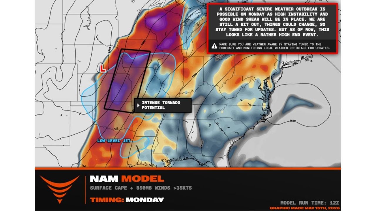
The tornado threat does not end with Sunday. Monday, May 18 is being described as having the look of a classic Great Plains tornado outbreak, with a volatile warm sector and intense tornado potential highlighted on forecast maps. A significant severe weather outbreak is considered possible on Monday as high instability and strong wind shear work together across the central and southern Great Plains. This is shaping up as a rather high-end, multi-day tornado event.
What Intense Tornado Potential Means for Locals
The term intense tornado potential means forecasters see the atmospheric ingredients in place not just for tornadoes, but for strong and potentially violent tornadoes capable of significant destruction. A classic Great Plains tornado outbreak setup typically means multiple tornadoes, some of which can be long-tracked and violent. This is not a situation to take lightly across eastern Nebraska and Iowa heading into Sunday and Monday.
Things Could Still Change But the Risk Is Real
Forecasters are noting that details could still shift as Sunday, May 17 and Monday, May 18 draw closer. However, the overall signal for a significant, high-end severe weather outbreak across eastern Nebraska, Iowa and the broader Great Plains is strong enough that preparation should begin right now. Do not wait for official warnings before identifying your shelter location.
What You Must Do Before Sunday
Anyone across eastern Nebraska and Iowa needs to act before Sunday morning, May 17. Identify the lowest interior room of a sturdy building as your tornado shelter now. Keep weather alert notifications active on your phone through both Sunday and Monday. Have a plan for your family, pets and vehicles before the first storms develop. A tornado outbreak can produce multiple tornadoes in a short period, leaving very little time to react once warnings are issued.
WaldronNews.com will continue tracking this intense tornado potential across eastern Nebraska and Iowa and will provide updates as the severe weather outbreak threat develops through Sunday, May 17 and Monday, May 18.