
Plains and Upper Midwest Brace for Major Tornado Outbreak Monday May 18 With 67% Severe Weather Probability and 30% Risk Zone Targeting Eastern Oklahoma and Kansas as Strong to Intense Tornadoes Likely
OKLAHOMA CITY, Oklahoma – A major severe weather outbreak is locked in for Monday, May 18 across the Plains and Upper Midwest, with forecast models showing a maximum severe weather probability of 67% and an official 30% severe weather risk zone now in place. Forecasters are specifically calling out eastern Oklahoma and Kansas for an increasing risk of strong to intense tornadoes, with Monday expected to be the worst day of a multi-day severe weather stretch.
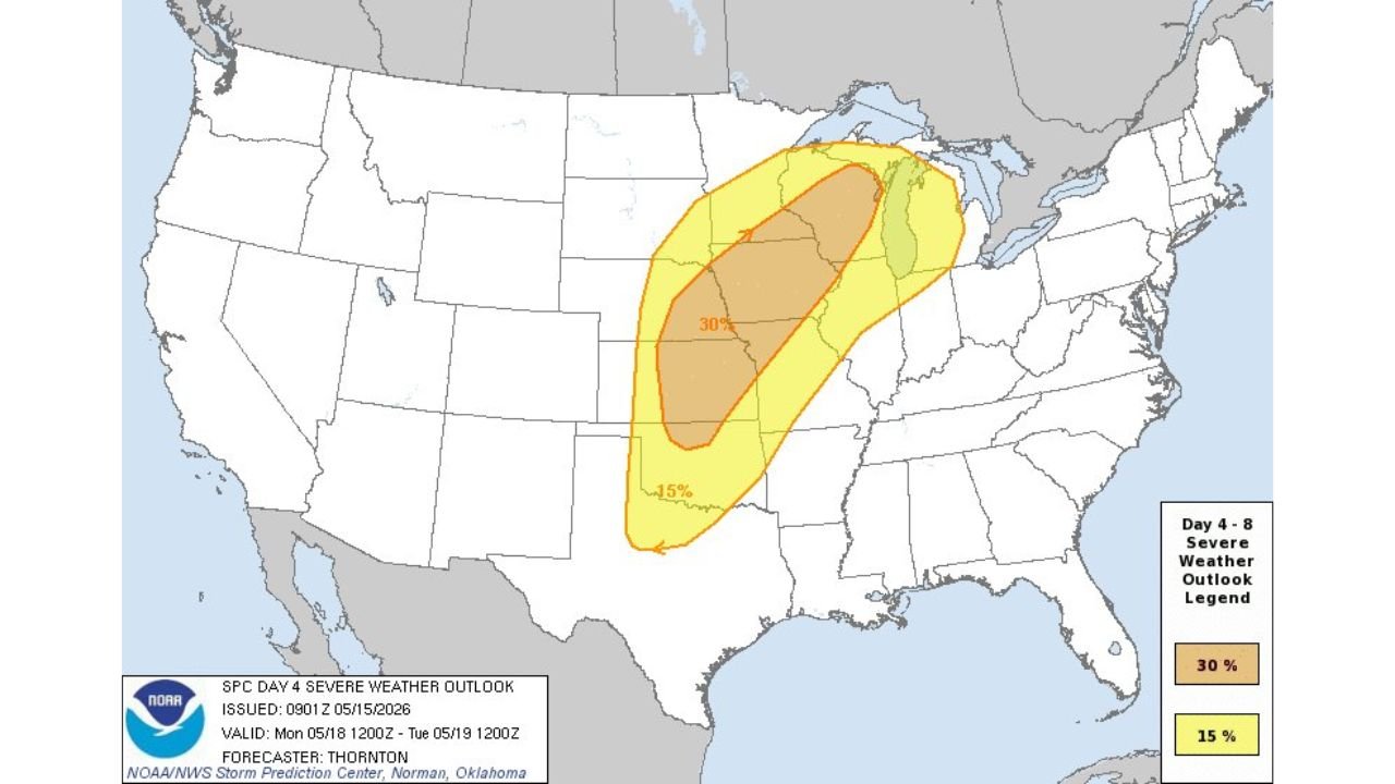
What the 67% and 30% Probability Numbers Mean
Two separate forecasting tools are both screaming the same message about Monday, May 18:
- A 67.3% maximum severe weather probability is the highest confidence signal showing in forecast data for the 24 hour period ending Tuesday morning, May 19. This level of probability for severe weather this far in advance is exceptionally rare and underscores how serious Monday’s threat has become.
- A 30% official severe weather probability is in place across the core risk zone covering Kansas, Oklahoma, Nebraska, Iowa and Missouri for Monday, May 18. A 30% severe weather probability means widespread severe weather is expected across the highlighted zone.
- The broader 15% severe weather probability zone extends the threat into Illinois, Wisconsin and surrounding states across the Upper Midwest for Monday, May 18.
Eastern Oklahoma and Kansas Face the Greatest Tornado Danger
Forecasters are specifically singling out eastern Oklahoma and Kansas for an increasing risk of strong to intense tornadoes on Monday, May 18. This language is significant because it goes beyond simply saying tornadoes are possible. Strong to intense tornadoes means forecasters see the potential for violent, long-tracked tornadoes capable of serious destruction across eastern Oklahoma and Kansas Monday afternoon and evening.
Monday Is the Worst Day of a Multi-Day Outbreak
The severe weather threat across the central and northern Plains has been building through the weekend, but Monday, May 18 is expected to be the peak and worst day of the entire outbreak. All severe weather hazards are on the table across the Plains and Upper Midwest on Monday, including:
- Strong to intense tornadoes with the greatest risk focused on eastern Oklahoma and Kansas.
- Large destructive hail capable of significant vehicle and property damage across the 30% risk zone.
- Damaging winds extending the threat well beyond the tornado corridor into the broader 15% zone across Illinois, Wisconsin and the Upper Midwest.
Washington DC Area Also Watching Wednesday
Beyond the immediate Plains and Upper Midwest outbreak, forecasters are already flagging next Wednesday, May 20 as a severe weather day to watch for the Washington DC area. This is an early heads-up for residents in that region to begin monitoring forecast updates as the week progresses.
What the 30% Zone Means Compared to a Normal Severe Weather Day
To put the 30% severe weather probability in context, a typical afternoon thunderstorm threat might carry a 5% to 15% probability. A 30% probability means forecasters have high confidence that widespread severe weather will occur across a broad area on Monday, May 18. Combined with the 67.3% maximum probability signal in forecast modeling, this is one of the more alarming severe weather setups seen this far in advance across the Plains.
What You Must Do Before Monday Morning
Anyone across eastern Oklahoma, Kansas, Nebraska, Iowa and Missouri needs a complete severe weather plan in place before Monday morning, May 18. Know your tornado shelter location now. Charge all devices this weekend. Keep weather alerts active on your phone all day Monday. Do not be caught outside or on the road during peak storm hours Monday afternoon and evening.
WaldronNews.com will continue tracking this major tornado outbreak threat across eastern Oklahoma, Kansas, Nebraska, Iowa and Missouri and will provide updates as the 30% severe weather risk and strong to intense tornado potential develop through Monday, May 18.