
Indiana Skies Fill With Horizontal Convective Roll Clouds Friday Evening May 15 Near Indianapolis, Greenwood and Bloomington Signaling No Thunderstorm Development Tonight
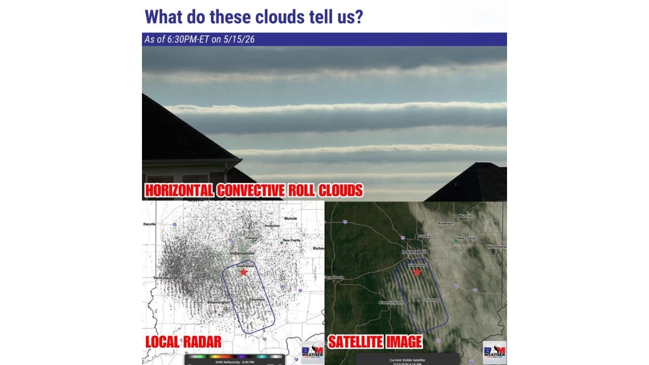
INDIANAPOLIS, Indiana – Striking horizontal convective roll clouds are visible across Indiana this Friday evening, May 15 as of 6:30 PM ET, and while they make for a dramatic sky photo, they are actually delivering good news for tonight. These unique clouds are a clear signal that a cap of warm air is suppressing thunderstorm development, meaning Indianapolis, Greenwood and Bloomington will see no storm activity this evening.
What Are Horizontal Convective Roll Clouds
Horizontal convective roll clouds are long, parallel bands of cloud that stretch across the sky in neat horizontal rows. They form when warm air near the surface tries to rise but gets pushed back down by a layer of warmer air sitting above it, called a cap. Think of the cap like a lid on a pot, physically preventing storm clouds from growing tall enough to produce thunderstorms. When you see these roll clouds, it is a reliable short-term signal that the atmosphere is capped and thunderstorms cannot develop.
Where the Roll Clouds Are Visible Tonight
Radar and satellite imagery captured at 6:30 PM ET on Friday, May 15 shows the horizontal convective roll cloud pattern centered across central Indiana:
- Indianapolis and Greenwood, Indiana sit at the heart of the roll cloud zone visible on both radar and satellite imagery as of 6:30 PM ET Friday, May 15.
- Bloomington, Indiana falls within the southern edge of the roll cloud pattern, with the cap clearly suppressing any storm development across this area tonight.
- Fishers, New Castle, Anderson and Muncie, Indiana are visible within the broader roll cloud zone on tonight’s satellite image.
- Terre Haute, Danville and Columbus, Indiana round out communities sitting beneath this capped atmosphere this Friday evening, May 15.
Why This Matters for Your Friday Night Plans
The presence of these horizontal convective roll clouds means the cap of warm air overhead is doing its job tonight, keeping storm energy locked in and preventing thunderstorm development across central Indiana. If you had outdoor plans for Friday evening near Indianapolis, Greenwood or Bloomington, the convective roll clouds are telling you the storms are not coming tonight. Enjoy the unusual sky view while it lasts.
A Weather Education Moment Worth Sharing
Not every interesting cloud formation means danger is coming. Horizontal convective roll clouds are one of the atmosphere’s natural signals that actually points toward calmer conditions in the short term. The cap suppressing storms tonight across Indiana is the same type of atmospheric feature that, when it breaks down on days like the upcoming Sunday, May 17 and Monday, May 18, can release enormous amounts of stored energy and fuel severe weather outbreaks. Tonight is calm. The days ahead are not.
WaldronNews.com will continue tracking storm development and atmospheric conditions across Indiana and will provide updates as the severe weather pattern for Sunday, May 17 and Monday, May 18 develops.